Patrick Marsh Wildlife Area
Introduction
Text-to-speech Audio
About a mile and half northeast of the City of Sun Prairie is the Patrick Marsh Wildlife Area. Currently it consists of 340 acres including a 160-acre lake. There are about 2.5 miles of trails. The Wildlife Area was restored to a wetland and dedicated in 1994 as a joint effort between the DNR and DOT. It was the first wetland mitigation bank site in Wisconsin. This allow the restored wetland at Patrick March to be used as credit for wetland the DOT had to destroy in road construction projects. Prior to the creation of the Wildlife Area the lake would periodically dry up and then refill. This characteristic played a role in the relationship between the lake and Sun Prairie’s social history. At different times, it was used for full immersion baptisms, production of cane back chairs, a carp farm, duck hunting, school picnics, and a summer swimming hole. It was also the subject of two lawsuits over riparian rights. Currently, it has used as an environmental education resource for Sun Prairie Schools and place where Sun Prairie residents can connect to nature.
Images
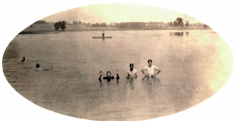
Swimming in the Old Lake
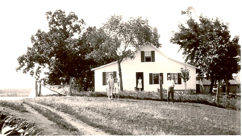
Dushask Summer House
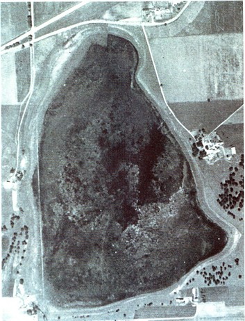
View from 1937
Backstory and Context
Text-to-speech Audio
Brazee Lake, Duscheck Lake, Patrick Lake, Ghost Lake, the Old Lake; the water at Patrick Marsh Wildlife Area has had many monikers over the years. Currently, the United States Geological Service labels it Brazee Lake on official maps, but historically the Sun Prairie community referred to it as the Old Lake, at least when there was water. The lake has a history of periodically disappearing creating a grassy marsh and then, with a change in climate, refilling recreating a lake. This dynamic feature was a defining characteristic of the “Old Lake” up until the creation of Wildlife Area in the early 1990s.
The basic topography of the Patrick Marsh Wildlife Area was shaped by the Wisconsin Glaciation, roughly 12,000 years ago. As part of the glaciation, a mile high ice sheet had progressed southwest across Dane County and stalled just west of the City of Madison. As the slowly glacier receded, a large chunk of ice fell off and a debris field formed around the chunk and eventually covered it. When the chunk of ice melted, the earth covering the top collapsed, leaving a very large shallow kettle pond. It is what’s called a raised basin, with no stream entering or leaving. Thus, the water level is determined by the balance between rainfall and evaporation.
Native Americans probably visited Patrick Marsh soon after the ice sheet retreated and would do so occasionally until the Europeans arrived in the mid-nineteenth century. Several small burial mounds have been identified at Carriage Hills that overlook the lake and date from before 1200 AD when mound construction flourished in Dane County. In recent years, the Ho Chunk Tribe prescribed a name to the Wildlife Area that translates to “where the Ho Chunk resides (or lays). Assumedly, this refers to the burial mounds. When Europeans arrived they described a network of Native American trails that crossed at the southern tip of the lake at Patrick Marsh. These were undoubtedly used to travel between their villages along Lake Koshkonong and the Rock, Wisconsin, and Fox Rivers.
The first Europeans to arrive at Patrick Marsh were the surveyors John Mullet and John Brink who had the task of defining the boundaries of Bristol Township. On Oct 12, 1833 they placed a post at the end of present day Town Hall Road, the southern tip of the Lake. A year later, the surveyor Orson Lyon and his team returned to divide Bristol Township into sections. At that time they also surveyed the outlines of a “pond”. Lyons calculated the size to be 157 acres, essentially the same size it is today. Six years later settlers arrived. The first was David Breeze’s family who settled on the east side of the lake in 1840. A year later, William Patrick and his family settled on the west side. It was for this family that the Wildlife Area is named. Interestingly, David and William had both emigrated with their families from Leeds County, Canada. They were brothers-in-law, having married two Davison sisters, Emily and Caroline.
The social history of Patrick Marsh is closely linked to the fluctuating water level of the lake. In the 1840’s, the lake was used for full immersion baptisms by the Sun Prairie Baptists. This practice was curtailed in the 1850s when the lake dried up, but reinstituted in the 1860s when it refilled. Indeed, in the 1860s the Methodists held “camp meetings” on its shore and performed immersion baptisms as well. However, by the early 1870s the lake had dried up again. It was so dry that William Sunnuchs, who did not own land bordering the lake, planted crops and filed a claim for a Federal Land Patent giving him ownership of the lakebed. The surrounding farmers, of course, disagreed with Sunnuchs and the dispute end up in Dane County Circuit Court. The Circuit Court ruled in favor of the farmers, but Sunnuch appealed all the way to the State Supreme Court. The Supreme Court returned the suit to the lower Circuit Court seeking more information. But then, nature gave its testimony. The lake refilled making the lawsuit mute. The lake dried up again in the years around the turn of the nineteenth century. Enough so, that Fred Fehrman of Bristol staring producing cane chairs from the materials at Patrick Marsh.
Beginning in 1910, abundant rainfall refilled the lake, and it reached a maximum depth of seven feet. It remained so until the mid-1930s. During this time, ice was harvested from the lake for Sun Prairie Creameries. In the late 1920s, there was an ill-fated attempt to convert the lake into a carp farm. Also, for a decade in the 1920s and 1930s the Duscheck farm on the west bank was the site of an annual Deansville Reunion, which attracted hundreds of participants. In the 1940s and 1950s, the water level receded again. Sometimes dry, sometimes 3-4 feet deep. In 1950, Robert McCabe of the UW Dept. Wildlife Ecology performed the first research at Patrick Marsh documenting the flora and birdlife. In 1965, it was dry enough that the farmers bordering the lake installed drain tile and pumps so crops could be raised. The Public Service Commission sought to block the farmers, but the Dane County Circuit Court ruled against the State. Thus, for nearly thirty years the lakebed would be farmed.
In 1989, plans were being made to convert Highway 151 between Sun Prairie and Columbus to a four lane and bring it up to full freeway standards. This set the stage for a wetland mitigation agreement between the DNR and the DOT. State law required that wetland lost due to widening of Hwy 151 had to be replaced. While the DOT only needed to replace 15 acres for the project, the Patrick Marsh site was 160 acres (with surrounding land the DOT would purchase 292 acres). A solution was found by creating the first wetland mitigation bank site. “Banking” would give the DOT credit for wetlands lost on other projects in Southern Wisconsin.
In June of 1990, work on the Hwy 151 rebuild began. In the fall of 1991, the last corn crop was harvested from the old lakebed and during that winter the DOT removed the pump but left the drain tile. By April 1992, the marsh began to refill and by the spring of 1993 was back to its “normal level” of 160 acres with maximum depth of seven feet. On September 30, 1994, there was a formal dedication of Patrick Marsh Wildlife Area including the unveiling of a sign.
The Hwy 151 rebuild included having the runoff from Hwy 151 flow into the lake. In addition, retention ponds at the business park on north side of the highway were installed in 2000. When these overflow they also bring water into the lake. Thus, the water level of lake as remained more or less constant from this time.
Currently, the non-profit Groundswell Conservancy manages the Wildlife Area in partnership with the DNR and local governments. Since 1994, additional land south of the original site has been added and planted with prairie flowers. It now comprising 340 acres with two and half miles of trails. The wildlife area has a reputation as a special spot for viewing birds, especially waterfowl. About ten years ago, white pelicans started visiting the lake which have added to the Wildlife Area’s allure. A unique feature that is worth the visit is a large metal sculpture installed by Groundswell that overlooks the southern tip of the lake. The sculpture is in the shape of a 30 ft high Phoenix surrounded by flames.
Sources
Hayden, Estelle, and Nora Noyes Philpot, et.al. Early History of Sun Prairie, scrapbook by the (Sun Prairie) Twentieth Century Club, 1935.