Register Cliff Historic Site
Introduction
Text-to-speech Audio
Images
To protect the cliff and grave sites, certain areas are restricted.

A member of the Willard family from Boston passed this way in 1855.

The state has erected various historic and informational markers.

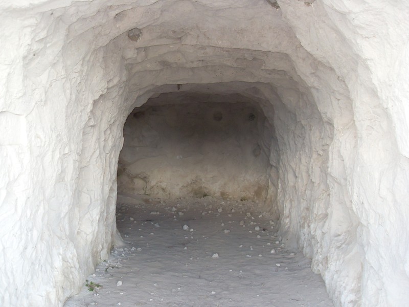
A cave was excavated into the cliff by farmers to store potatoes and other crops during the winter months.
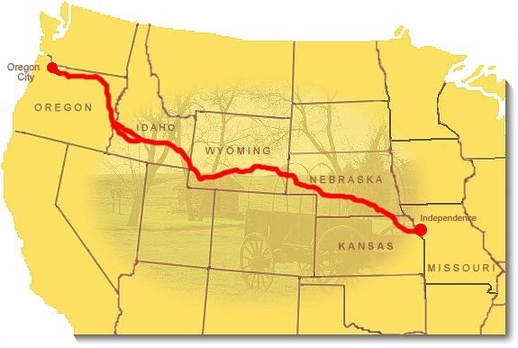
A map of the Oregon Trail. Register Cliff is located in eastern Wyoming.
Backstory and Context
Text-to-speech Audio
The Oregon Trail was a 2,100-mile overland route that brought travelers west from points along the Missouri and Mississippi Rivers primarily during the mid-19th century. It traversed present day Kansas, Nebraska, Wyoming, and Idaho prior to reaching Oregon. The beginnings of the Oregon Trail were cut by fur trappers and traders in the early 1800s, especially by members of John Jacob Astor’s Pacific Fur Company and those employed by the Hudson’s Bay Company.
Initially a foot and horse path, sections were widened over the decades to allow for the passage of wagons and annual improvements were made such as fords, bridges and ferries. One of the first migrant wagon trains was organized in 1836 in Independence, Missouri and others soon followed. Many migrants used the eastern half of the Oregon Trail prior to branching off to the California and Mormon Trails after crossing the Continental Divide. Eventually, over 400,000 people used the trail to head west, most during its peak years of use from 1846 to 1869 when completion of the Transcontinental Railroad made the trail obsolete.
The vast majority of those westward travelers stopped at Fort Laramie, Wyoming which was a private trading post prior to being purchased by the U.S. Army in 1849. They stopped to rest and stock up on supplies prior to ascending the Continental Divide at South Pass. Just to the northwest of Fort Laramie and prior to reaching South Pass, the migrants came across a large grassy area next to a 100-foot limestone cliff which had been eroded by the North Platt River. It proved to be a great location to stop, water and feed their teams and carve their names and date of arrival into the cliffside for all who came behind, to include friends and family, to see. The spot became a geographical landmark of sorts and was soon listed in trail guidebooks.
Over the years, wind and weather have erased some names from the cliff with the earliest legible name dating back to July of 1829. It is possible to trace the history of some of the names carved in the cliffside. For example, “A.A. Withrow” was Abel Alderson Withrow, a saddler from Indiana who passed Register Cliff on his way to California. He later became a member of the “Fighting Californians” assigned to the 2nd Massachusetts Cavalry during the Civil War and died in 1911. Three extended members of the Unthank family “signed” the cliff with the first being Alvah Hunt Unthank on June 23, 1850. Unfortunately, he died of cholera a week later and his gravesite remains near Glenrock, Wyoming. Roughly ten percent of travelers perished during the journey, most, like Alvah Unthank, from disease.
Eventually, two enterprising individuals named Ward and Gurrier opened a small trading post near the cliff that later became a pony express stop and then a stage station. All that remains is the chimney base. Beginning in 1880, Charles Guernsey, the nearby town’s namesake, owned and operated a ranch in the area which was sold to Henry Frederick. Frederick donated the land, which is now the Register Cliff Historic Site to the state in 1932. Unfortunately, since that time, people have recently added their names to the cliff, sometimes marring the names of those who travelled the Oregon Trail almost 200 years ago. The state has added a walking trail along the cliff face, have cordoned off unmarked graves, and added informational markers at the site. Register Cliff is open daily from sunrise to sunset.
Sources
Barnhart, Bill. "National Register of Historic Places Nomination Form: Register Cliff." United States Department of the Interior/National Park Service. December 19, 1969. Accessed May 19, 2020. https://npgallery.nps.gov/NRHP/GetAsset/NRHP/70000674_text
"Register Cliff." WYOHistory. November 8, 2014. Accessed May 19, 2020.https://www.wyohistory.org/encyclopedia/register-cliff
Weiser, Kathy. "Register Cliff, Wyoming - Historic Guestbook on the Plains." Legends of America. November, 2019. Accessed May 19, 2020.https://www.legendsofamerica.com/wy-registercliff/
Brooke, Bob. "Oregon Trail - Facts, information and articles abut the Westward Expansion." Historynet. April, 2000. Accessed May 19, 2020. https://www.historynet.com/oregon-trail