Bronx River Parkway Reservation
Introduction
Text-to-speech Audio
In 1907 the Bronx River Parkway Commission was formed. The Bronx River Parkway was a pioneering effort in regional planning involving city, county, and state governments in the construction of a 15-mile parkway from the Bronx Botanical Gardens to the Kensico Dam. The plan included river cleanup and reclamation, public health measures, a landscaped parkway, residential displacement and renewal, and the reconstruction of the public memory of the Bronx River Valley. It was the first restricted access automobile “parkway” in America, thereby enhancing the suburban experience for Westchester residents and visitors.
Images
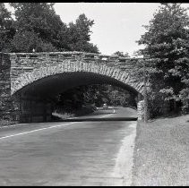
Popham Road Bridge
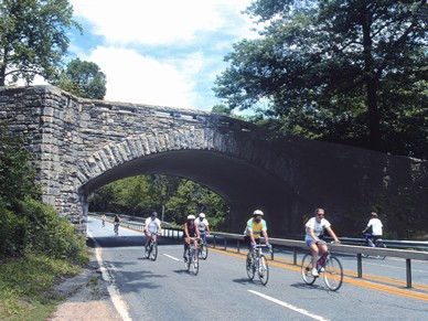
Bicycle Sundays
Backstory and Context
Text-to-speech Audio
The Bronx River Park Reservation was a pollution control project to relieve the severe contamination of the Bronx River in the late nineteenth century. As with many waterways of the era, the Bronx River was used as a sewer and dumping ground. Having unanimously deciding that a reservation should be created to preserve the Bronx river, a commission was formed to plan and acquire the land necessary to create the preserve. Between 1906 and 1907 funding and planning for the parkway began. Six years after it was formed, the commission began acquiring land and started clean up. The purchase of the first parcels of land were in 1913. The Bronx Parkway Commission, as it was called, hired forester, Albert N. Robson, who was noted for his tree care expertise. The reservation was a success long before the actual parkway was completed, because the project strongly influenced public sentiment in favor of additional parkways, recreational facilities, and improved transportation routes. By 1916 construction on the roadway and park had begun. However, construction of the parkway was delayed during the war years, as well as from financial and political wrangling between Westchester County and New York City.
Officials and real estate interests along the right-of-way of the parkway had every reason to anticipate the land values would increase, based on the experience of other cities such as Boston. The Real Estate Record of Westchester touted the roadway as an excellent opportunity to stimulate the county’s economy and boost real estate values which proved to be correct. In 1910, the land in the parkway area was valued at $22 million. By 1932, it had risen to $281 million, an increase of 1,278 percent. The Bronx River Parkway officially opened on November 5, 1925. The parkway stimulated residential development all along its route through Scarsdale, Bronxville, Yonkers, Hartsdale etc.
Today, The parkway has become a major arterial highway, carrying car at speeds as high as its narrow lanes and daunting curves will allow. The only time the parkway serves anything like its original purpose is on Bicycle Sundays, when cars are banned and the road is taken over by bicyclists, runners, and skaters, all moving slowly enough to enjoy the scenery.
Sources
The Bronx River Parkway Reservation Conservancy, “America’s First Park: Westchester’s First Park” https://www.bronx-river.com/history
“Chapter 669 of the Laws of 1906,” Report of the Bronx Parkway Commission (Albany: J.B. Lyon Company, State Printers, 1907)
The Historic American Engineering Record (HAER), Bronx River Parkway Reservation, http://westchesterarchives.com/BRPR/BRPRHome.html
Williams, Grey. Jackson, Kenneth T. Picturing Our Post: National Register Sites in Westchester County. New York. 2003
Roger Panetta (editor), Westchester: The American Suburb (New York: Fordham University Press and the Hudson River Museum, 2006, 258.
https://westchester.pastperfectonline.com/photo/F156BB51-6981-42F1-B1DC-723638480630
Williams, Grey. Jackson, Kenneth T. Picturing Our Post: National Register Sites in Westchester County. New York. 2003