Grassy Island Range Lights
Introduction
Text-to-speech Audio
The Grassy Island Rights Lights are a pair of mid-nineteenth century lighthouses that are currently located on the east bank of the Fox River on the grounds of the Green Bay Yacht Club (please note that the address under location is the club's address and the GPS coordinates are for the lighthouses). They are no longer in use however they are fully restored and equipped with lights. They were originally located on Grassy Island, which is now smaller than it used to be due to significant dredging, to help ships navigate the lower part of Green Bay and the mouth of the Fox River. The taller house is 35 feet tall and the other one is 25 feet tall and were equipped with eight-sided lanterns and lenses made in France. The lights could be seen 12 miles out on clear days. The lighthouses were added to the Wisconsin Register of Historic Places in 2004 and the National Register of Historic Places in 2005.
Images
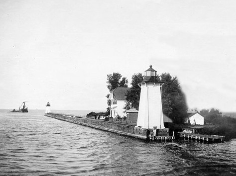
The lighthouses in 1914. Credit: U.S. Coast Guard
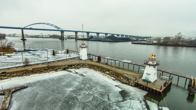
The lighthouses on the breakwall
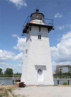
The taller lighthouse
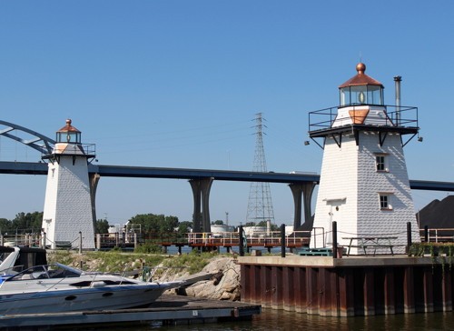
View of the lighthouses looking southwards
Backstory and Context
Text-to-speech Audio
As early as the 1830s, the need for lighthouses on the southern end of the Green Bay became apparent. In 1837, the Board of Navy Commissioners appointed Lieutenant G.T. Pendergrast to assess the feasibility of proposed lighthouses in the Great Lakes. After he surveyed Green Bay, he recognized that a lighthouse was needed where the mouth of the Fox River met the bay. Entering the river from bay was treacherous due to several sand bars, including Grassy Island, that prevented ships from passing through safely. Pendergrast recommended that a lighthouse be built on Grassy Island. The island was located approximately a mile and a half from the mouth of the river and it blocked the primary route of entry into Green Bay harbor.
However, it wasn't until 1864 that the process for constructing a lighthouse was set in motion. The committee of the lighthouse board officially determined that the southern end of the bay needed a lighthouse. Dredging began in the fall of 1866 and a channel—200 ft. wide, 9 ft. deep, and about 2 miles long—was cut right through Grassy Island. Sheet pilings were installed along the banks of the channel to prevent the sand from falling back in.
Finally, in 1872, two lighthouses were built on the east side of the channel. Both were painted white but in 1934 were painted green in order to help sailors distinguish them from Green Bay's lights. They were place 700 feet apart and several other structures, including the keeper's house, a woodshed, and a boathouse were also built. One lighthouse was designed to be 35 ft. tall and the other 25 ft. tall in order to help sailors determine the direction, either north or south, they were headed. The shorter lighthouse was closest to the mouth of the river.
The lighthouses had several keepers. Louis Hutzler served as keeper for thirty-three years from 1903-1933, the longest term held by any keeper. Gas lights were installed in 1934 and as result keepers were no longer needed. The lighthouses continued to assist sailors navigate the entry into the Fox River until 1966, when the need for more dredging became apparent. It was suggested that the lighthouses be burned but members of the Green Bay Yacht Club mobilized an effort to save them and they were moved to the club's parking lot that same year. They remained there until 1999 when they were moved to the breakwall along the east bank of the river that protects the docks. After a restoration effort that lasted several years at the cost of around $400,000, the lighthouses were dedicated in a public ceremony in November 2005.
Sources
http://www.lighthousefriends.com/light.asp?ID=556
Wardius, Ken; Wardius, Barb (2013). Wisconsin Lighthouses: A Photographic and Historical Guide. Wisconsin Historical Society Press. pp. 87–90.
"100 Bay Beach Road". Wisconsin Historical Society. http://www.wisconsinhistory.org/Content.aspx?dsNav=N:4294963828-4294963813&dsNavOnly=N:1160&dsRecordDetails=R:NR2074