Sandy River Bridge
Introduction
Text-to-speech Audio
Images
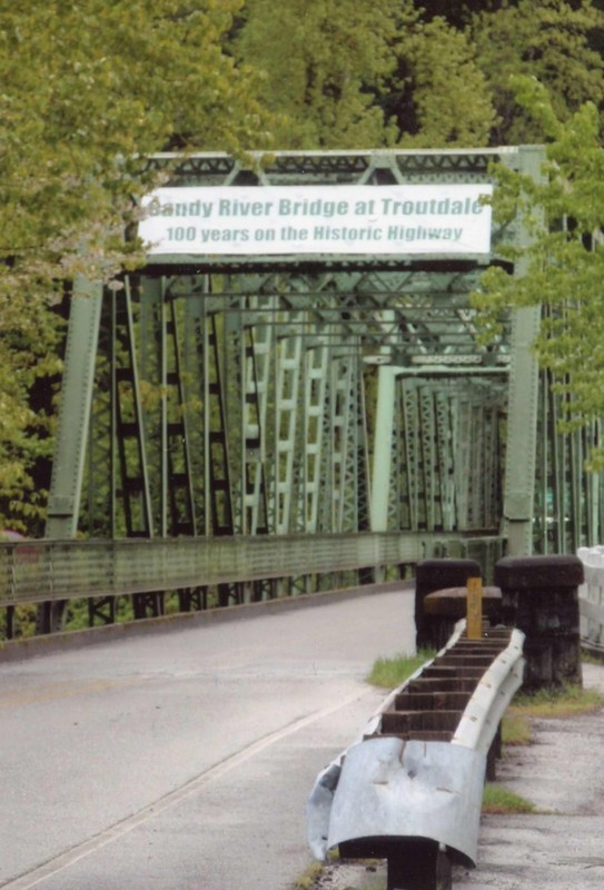
Celebrating the 100th anniversary of the Sandy River Bridge, 2013.
Sandy River Bridge, 2021. A new wider walkway was installed in 2020.
_cropped.jpg)
Backstory and Context
Text-to-speech Audio
Sandy River Bridge
Year Built 1912/1913
Common Name: Troutdale Bridge
Location: In Troutdale, Oregon at the western entrance to the Historic Columbia River Highway.
Description: Two 162-ft riveted steel Pratt through truss main spans with a plate girder approach span.
Designer: Waddell & Harrington, Consulting Engineers, Kansas City.
Builder: Oregon Bridge & Construction Company, Portland; Northwest Steel Company, Portland (Fabricator).
Significance: Shortly after Multnomah County built the bridge on a county road, it became one of the two entry points to the new Columbia River Highway. In the early 1920s, OSHD took over the bridge as a part of US 30. It features a lacing rail on the inside of the truss and a sidewalk along the outside of the truss on the upstream side. Just west of the truss on the same road is the Beaver Creek Bridge, built at the same time by the county. It is a 40-ft concrete deck girder span with arched girders and a heavy concrete rail that has been recently restored (2013).
Character Defining Features: Structure type, Nameplates, Decorative railings, Location relative to the Columbia River Highway.
Alterations: The only major alterations to this bridge have been the replacement of the deck and sidewalks, and the loss of the masonry rail on one corner. [2020 southside walkway improvement]
Sandy River
The Sandy River (called Quick Sand River by Lewis and Clark (1805) due to accumulation of volcanic ash at the rivers delta as it met the Columbia River) runs through the town of Troutdale. In its early days, Troutdale residents on the east side of the Sandy River would take the ferry and later a wood bridge to cross over the river to come to town to work at the meat packing plant, bring their produce for shipment via the railroad, purchase goods at the stores, or visit friends and family.
In 1912 the construction of a new steel bridge began. This bridge became the beginning of the Columbia River Highway that stretched 74 miles to The Dalles, Oregon. It was the major thoroughfare for those traveling east. In 1984 a group placed the Columbia Highway (Hwy 30) on the National Registry of Historic Places and designated it as the Historic Columbia River Highway.
Smelt Runs
"... in the chill spring, simply spot just one small silver fish. Just see twin shimmers in the water. And the cry goes up: "Smelt run. Smelt run. The smelt are here. Get the nets. Smelt in the Sandy!" (Sharon Nesbit, It Could Have Been Carpdale).
The small silver fish swim up the Sandy River to spawn in early spring. The event of the spring run of smelt did not occur every year. No one could or can predict when the smelt will return. But when they did the fish could be so thick in the water you felt you could walk across the water on their backs. Men, women and children would come to the Sandy River with nets and buckets to get their fill of smelt. Many locals relied on the smelt runs for their commercial fishing business. Restaurants would pop up offering fried smelt dinners. Gas stations sold fishing licenses and dip nets. Smelt runs were big business for the small town of Troutdale. The center of activity was the Sandy River Bridge. The best spot to watch the action was on the southside walkway.
Sources
Nesbit, Sharon . It Could Have Been Carpdale - Centennial History of Troutdale, Oregon. Edition First. Volume . Battle Ground, Washington. Pediment Publishing, 2007.
Burrow, Rebecca, Author, et al. Oregon's Historic Bridge Field Guide. 2013. Web.. Retrieved from the Library of Congress, <lccn.loc.gov/2014489971>. Sandy River Bridge, page 211.
Troutdale Historical Society
Troutdale Historical Society