Somerset Place Driving Tour Stop #2: Thirty Foot Canal, Carriage Drive, and Lake Phelps
Introduction
Author-Uploaded Audio
Listen to a narration of this entry's description by Somerset Place State Historic Site User.
Text-to-speech Audio
- Follow the parking lot road to your right and walk to the grass trailhead that crosses over Thirty Foot Canal. This canal was hand-dug by the enslaved community in the 1840s and/or 1850s to drain the central portion of the plantation, beginning here and continuing downstream to the Scuppernong River. However, the canal did not originally connect with the lake. It gets its name from its size: the canal was six feet wide closest to the lake and grew progressively to reach 30 feet wide near its mouth at the river.1
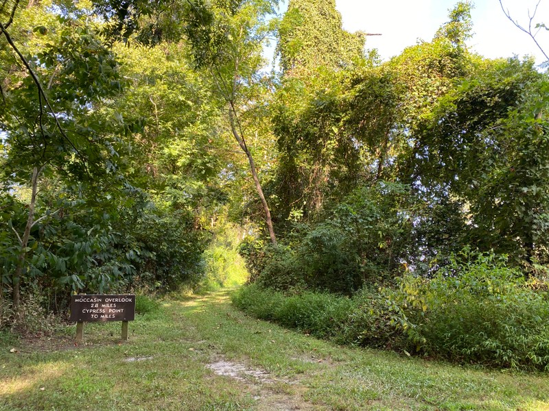
- The trail you are standing on is also historic. Originally this was a 4-mile-long carriage drive that ran along the northeast shore of Lake Phelps. Enslaved persons built this road atop a dike that prevented the lake from overflowing into the fields. They also planted sycamore trees on either side for shade. Some of these trees remain along the historic roadbed which is now part of two hiking trails within Pettigrew State Park: Bee Tree and Moccasin Trails.
- Follow the trail in reverse until you reach the paved road again, walk toward the water, and stand near the boat ramp to Lake Phelps. The lake, which was called Lake Scuppernong during the antebellum era, is the second largest natural lake in North Carolina at 16,600 acres. It was a vital component of the plantation. Using a series of locks and millraces in the Transportation Canal, the lake provided waterpower to the four-story barn, gristmill, and sawmills. Enslaved persons fished in the lake and set traps for game along the shore to supplement their diet. They also collected water for cleaning and bathing. In contrast, the Collins family primarily used the lake for recreational activities like sailing. However, there was no wharf on the lake as there is today. After viewing Lake Phelps, return to your vehicle.
Images
Thirty Foot Canal from the grass trailhead.
.jpg)
Thirty Foot Canal as seen from several miles down the road.
.jpg)
The historic carriage drive that is now Moccasin Trail.
Lake Phelps
.jpg)
Lake Phelps
.jpg)
Backstory and Context
Author-Uploaded Audio
Listen to a narration of this entry's description by Somerset Place State Historic Site User.
Text-to-speech Audio
In the following quote from 1839, Edmund Ruffin describes the carriage drive. He references both Somerset Place (“Mr. Collins’ farm”) and the adjacent Bonarva Plantation (“Mr. Pettigrew’s”), the latter owned by Ebenezer Pettigrew: “The lake side of both the adjoining farms is alike protected by a low dike. This dike, with the bridges across the canals, forms a continuous road for two miles along Mr. Collins’ farm, and apparently as much more along Mr. Pettigrew’s. This road keeps near the lake shore, and forms, both by its situation and its decorations, one of the most beautiful and extensive promenades, either for walking or driving, that I have ever known road is perfectly level in its course, firm and dry. It is planted throughout on the side from the lake with rows of trees, which are of different sizes according to the date of the clearing of the fields along which they are planted. One of these rows, on Somerset Place, a mile in length, is of tall and noble sycamores, all of the same age and of very equal size. […] Between the road and lake is a narrow and irregular margin, under its natural and usual swamp growth, among which are some trees of very large size, and other as remarkable for their grotesque form.”2
Sources
Somerset Place State Historic Site research files.
1 Edmund Ruffin, Agricultural, Geological, and Descriptive Sketches of Lower North Carolina, and the Similar Adjacent Lands (Raleigh: Institution for the Deaf & Dumb & The Blind, 1861), 235.
2 Edmund Ruffin, “No. 7. Uses of water power. Mr. Pettigrew’s farming and improvements,” The Farmers Register, a Monthly Publication, Devoted to the Improvement of the Practice and Support of the Interests of Agriculture 7 (1839): 730.
Somerset Place State Historic Site
Somerset Place State Historic Site
Somerset Place State Historic Site
Somerset Place State Historic Site
Somerset Place State Historic Site