Old Katonah
Introduction
Text-to-speech Audio
To quote local historian Gray Williams, Katonah was, “the village that wouldn’t drown.” The village uprooted from its original location and moved due to the construction of the New Croton Dam and the enlargement of the Croton Reservoir. The construction of the dam was needed to provide additional water for a growing New York City population. The village continues to survive today because its residents banded together to purchase land for a new village and ambitiously moved many of its original buildings.
Images
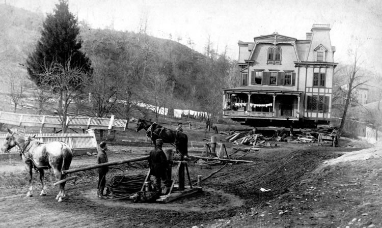
A house being moved from the Old Katonah village
The former Methodist Manse at its site in Old Katonah
.jpg)
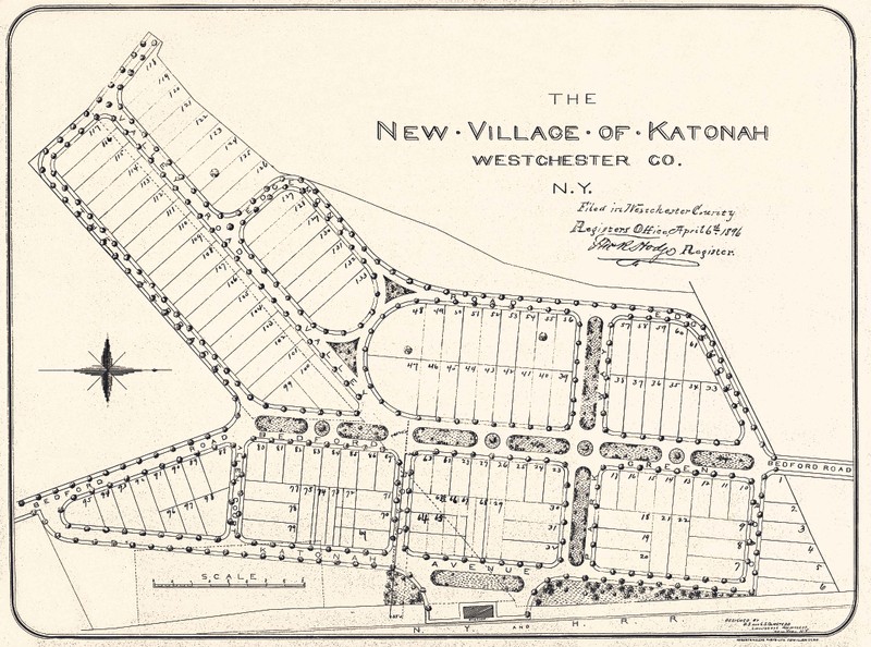
Layout of the New Katonah Village
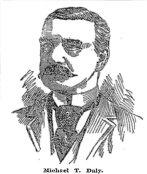
Former NYC Commissioner of Public Works, Michael T. Daly, Who Served from 1893-1895
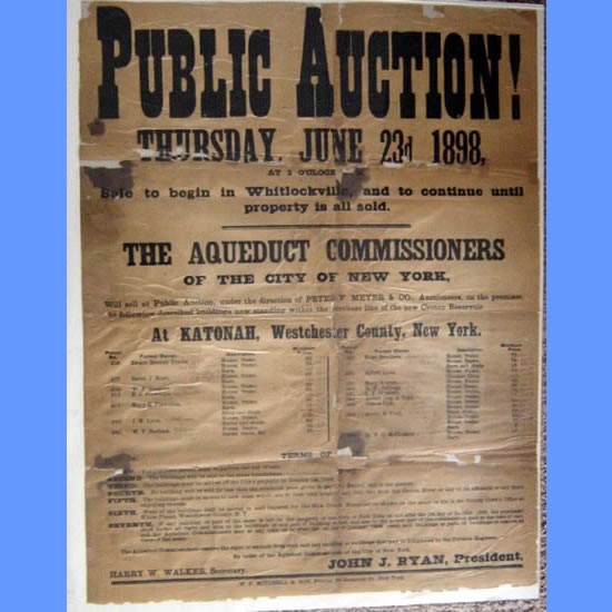
An Example of an Auction Poster from the Old Katonah Village
Backstory and Context
Text-to-speech Audio
The village of Katonah can be divided into two periods of history: before and after the construction of the New Croton Dam. Prior to this move, the area of Old Katonah consisted of two hamlets: Cherry Street and Whitlockville. Cherry Street was on the decline due to the growth of Whitlockville, which expanded downhill in order to create more businesses for the village. However, Whitlockville later faced decline because the New York and Harlem railroad bypassed the village. Despite this setback, the area’s economy shifted towards a dairy-based economy, as the railroad now allowed for milk to be transported rapidly to the city. The nightly milk train connected the local railroad stations to New York City, and businesses sprung up around it, including in Katonah.
The birth of Old Katonah could be dated to July 22nd, 1852, when the post office along the railroad was transferred to the village. The railroad station, named Whitlockville Station at the time, became the hub of the Old Katonah village. Businesses and homes moved their locations to be nearby. It was a quiet village until some of its men would volunteer during the Civil War to serve the Co. G, 38th Regiment. However, the fate of the village came into question as early as 1875 when resident Ophelia Avery reported that civil engineers were stationed in the village doing surveys of the area. During the 1880s, the New York City Aqueduct Commission began planning to enlarge the Croton Reservoir and to construct a new dam, which would prove to be the end of Old Katonah.
On April 7th, 1893, Commissioner Michael T. Daly ordered the destruction of Kirbyville, New Castle Corners, Old Katonah village and parts of Kensico.. In September that same year a letter of condemnation was sent to the village seeking the removal of at least 100 buildings. Since Katonah was a hamlet within the Town of Bedford at this time (and still is today), the village lacked an independent government to organize the transplant of Old Katonah and Whitlockville, so the task fell to the Village Improvement Society. This delegation needed to find a new site for the village. Many of the old buildings within the village went to auction and then demolition. Others were preserved and moved. However, the exodus was quite messy, as the original deadline for removal was changed two years forward to May 1895.Yet despite many conflicts, the village succeeded in moving to its new location which was quite an achievement.
During the relocation during 1896 and 1898, the preserved buildings were either dismantled and reassembled at new locations, such as the St. Mary’s Church, or uprooted in their entirety and transported on timbers, such as the former manse of the United Methodist Church. The buildings moved by these timbers were connected by cables to horse-drawn capstans that were aligned along tracks of hard yellow pine. To ease friction, these pine tracks were lubricated with soap. Sometimes the tracks would shift in front of them, but by far the most impressive engineering feat of these long tedious moves was the construction of temporary bridges to cross the Croton River.
The formation of the New Katonah village began with the purchase of 37 acres of farmland perpendicular to the railroad approximately 1-mile south of the old village. The land was purchased by the Katonah Land Company. This syndicate hired B.S. and G.S. Olmsted landscape architects to create the plan for the village. Italian workers were hired to level and grade the lands of the village for construction. Thanks to the landscaping talent of the Olmsted fim, the village was constructed with wide roads with parks running through the center of them. The new village had some ordinances enacted to foster orderly development; these were enforced through the enactment of restrictive covenants upon the deeds of the sold lands. These restrictions varied from the ban on noxious scents and the manufacturing of certain items (soap, candles, starch, glue, ink, or gunpowder), to the ban of slaughterhouses or tanneries, a ban on harboring pigs, poultry, or vicious dogs, and even the prohibition of alcohol within the village. Temperance was popular within the village due to alcohol use running relatively unchecked in the old village, thus some residents petitioned the syndicate to restrict its sale and manufacture in New Katonah. The first buildings in the new village were the Palmer Avenue School in 1893 which replaced the old school which had burned, and the Pioneer House built in 1895, which was the first house built in the new village.
The first train arrived in the new village on April 5th, 1897. First Presbyterian Church and United Methodist Church constructed new houses of worship in the new village, while St. Mary’s reassembled its old house. Cemeteries were reinterred to new burial grounds. Events such as horse races and bicycle races were held in the village, and the first automobile was spotted in the village in 1899. Katonah was changing and growing; even the prospect of a National Bank in the village was explored. As a result of the move, the village survived and prospered, but its history was forever changed.
Sources
Duncombe, Frances. Katonah: The History of a New York Village and Its People. Katonah,
NY: The Society, 1961.
Williams, Gray. Picturing Our Past: National Register Sites in Westchester County. Elmsford,
NY: Westchester County Historical Society, 2003.
“New York SP Katonah Village Historic District.” National Archives and Records
Administration. National Archives and Records Administration, August 12, 1983.
https://catalog.archives.gov/id/75323077.
“DESTRUCTION TO KATONAH; MR. DALY ORDERS ITS REMOVAL FROM THE FACE OF THE EARTH. TWO SMALLER VILLAGES IN THE CROTON WATERSHED ALSO CONDEMNED -- IMPORTANT ACTION IN KENSICO AND MOUNT KISCO -- SECOND CAMPAIGN AGAINST THE MICROBES. DESTRUCTION TO KATONAH.” The New York Times, April 8, 1893, 42 edition.
https://www.nytimes.com/1893/04/08/archives/destruction-to-katonah-mr-daly-orders-its-removal-from-the-face-of.html
Westchester County Historical Society
Westchester County Historical Society
The New York Times, May 2nd, 1893 (https://timesmachine.nytimes.com/timesmachine/1893/05/02/106821836.html?pageNumber=9)
Westchester Archives and Katonah Village Public Library Local History Room (https://www.westchesterarchives.com/ht/muni/bedford/katonahFull.htm?auctionPoster.x=33&auctionPoster.y=65)