Roche's Station (Ghost Town)
Introduction
Text-to-speech Audio
Roche’s Station was a stop on the Chicago & Erie Railroad. By 1903 the stop was long gone, replaced by Simpson a couple of miles up the railroad tracks towards Huntington.
Images
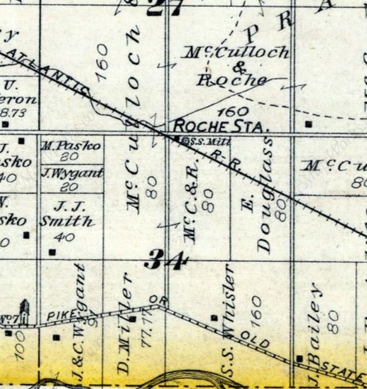
Roche's Station
Backstory and Context
Text-to-speech Audio
The 1879 Combined Atlas shows the hamlet of Roche’s Station in the middle of property owned by McCulloch & Roche and having a saw mill.
Roche’s Station had a very brief moment of notoriety. From the 24 Dec 1879 Fort Wayne Weekly Sentinel:
“The people of Oxford station, Mich., are greatly excited in consequence of grave robberies committed there Thursday night. The ghouls were tracked to Roche’s station, where two men having three dead bodies in their possession were arrested. Friday morning one of the bodies was identified as that of Robert Ensley, buried last Sunday, and another as that of Jas. Dove, buried on Wednesday, and the third was that of Mrs. Plumford, who was ninety years of age at the time of her death.”
Which begs the question – where were they going? Perhaps to Indianapolis or somewhere else with a medical college in need of cadavers for practice.
An interesting side note is that by 1914 the locations of Roche Station and Simpson were conflated into a single location. The period maps of 1879 and 1903 when used together show that they were actually about two miles apart.
Sources
- Combination Atlas Map of Huntington County, Indiana. 1879. Kingman Bros.
- Huntington County, Indiana. 1903. Herman Taylor. Warsaw, Ind.: National Map Co.,. Rockford, Ill.: Hixson Map & Litho. Co.
- Fort Wayne Weekly Sentinel, Wednesday, 24 Dec 1879, page 7, right column.
1879 Combined Atlas of Huntington County, Indiana