The Great Miami River and The Flood of 1913
Introduction
Text-to-speech Audio
The Great Miami River has been the backbone of a lot of great stories and the build up of civilization near the river. The has done a lot of good in the past for new settlers giving them a nice source of food and a way of transportation. The river is still a nice part of everyday life but in 1913 the Miami Valley would have a very different opinion on this River. In 1913 The Great Miami River flooded and with the flood ruining thousands of peoples homes. The flood was so back it called for immediate action to find a fix for this issue to ensure nothing like this could ever happen again. The immediate action that was called for was a plan to construct a series of dams and levees build in and around the river to high the land around the river making it harder to overflow.
Images
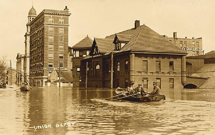
This image shows civilians scouting the area looking for other in need of help to try and get them to safety. The flood lasting four days mean thats this image would have been more towards the beginning of the flood as the water is still high and the survivors are looking to rescue people.
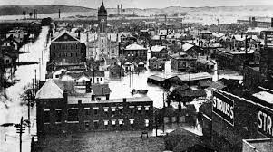
This is a image of Downtown Troy showing what the town looked like. This gives a more in depth look how how the flood could have effect so many and have been so dangerous for the close living conditions.
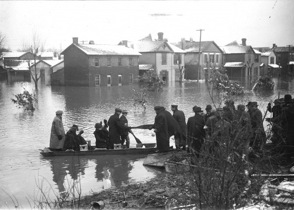
This image shows survivors getting to sloid ground and a safe area. The flood was so bad that there were not many safe places to be considered safe so the surviors would be stranded on little hills that were above the water and would stay there until the after would slowly drain out.
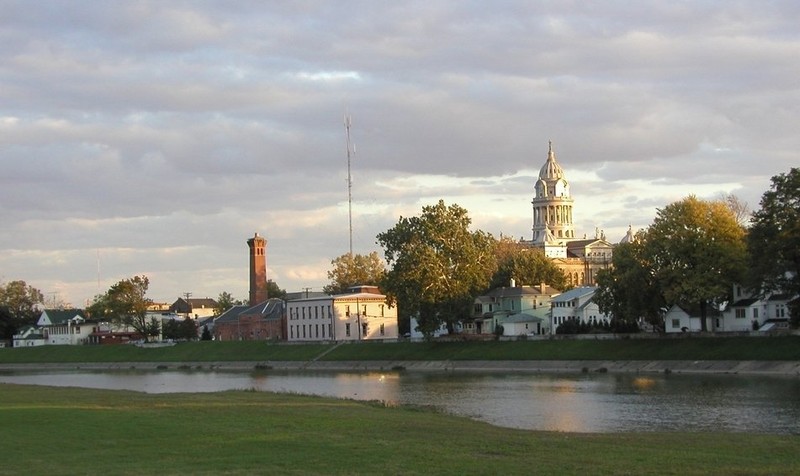
This is a more recent picture of Troy. Now this picture is to show you what the levy looks like which was a response to the flood in order to keep the water levels under control.
Backstory and Context
Text-to-speech Audio
The Great Miami River has played a significant role in the landscape and how Troy became the town it is today. The river got its name from a Algonquian-speaking Native American people who lived in the region during the early days of Europeans settlement. The Great Miami river starts from the man made Indian Lake and continues to flow south into Hamilton near Cincinnati. The Great Miami River stretches a total of 170 miles. This river is rich in history for what it has put nearby civilians through, making many adaptations needed to sustain this river.
The Great Miami River is rich with history such as, disasters, job opportunity, and shaping cities have all come from The Great Miami River. This 170 mile long river has had many stories of disasters, one of them dates back to 1913 when mass amounts of rainfall built up in late March. This caused the river to rise and continue to rise over this period of time. The river flooded most of the Dayton area with a max height of 10 feet of water. This flood lasted four days until it was all drained or evaporated, with that peoples valuables were severely damaged in the flood. The flood took the lives of more than 360 people and caused $100 million in damage back in 1913 (This about 2.8 billion dollars in the 2022 economy). Shortly after the flood washed away, about 23,000 people gathered nearly $2 million to apply a protection system where a water-control engineer Arthur Morgan took the task to design a protection plan.
Arthur Morgan took a look at the Dayton area over the summer, checking out the river and how he could solve any further issues like this. On October 3rd Arthur would give a lengthy report to the committee on an idea of constructing five storage reservoirs, or "Dry-dams" along with standard improvements of the rivers channel. This standard improvement that was brought up was the idea of building levees on either side of the river to elevate the earthworks to try and keep the water from rising above and flooding communities. The public was quite doubtful of the plan but it was approved by the committee anyway, Arthur was giving the rights to start his project. The dry dams were implemented from 1914-1918 when that was finished they quickly mad a turn around to start on the construction of the levees in these areas (Germantown, Englewood, Lockington, Taylorsville and Huffman. Downstream of the dams, levees were built in Piqua, Troy, Tipp City, Dayton, West Carrollton, Miamisburg, Franklin, Middletown and Hamilton.) This construction process was then finished in 1922 as a total of 2,000 men worked on this. The total project ended up costing $30 million (nearly $8.6 million in the 2022 economy). At the end of 2021, the retarding basins collectively had stored floodwaters 2,085 times since the original system was completed in 1922.
Sources
D.Schlegel, S. C. /. (2022, February 7). Construction: Miami conservancy district. Miami Conservancy District " Protecting. Preserving. Promoting. Retrieved March 14, 2022, from https://www.mcdwater.org/about-mcd-2/the-history-of-mcd/construction/
D.Schlegel. The Great Flood of 1913: Miami Conservancy district, Miami Conservancy District "Protecting. Preserving. Promoting.. April 12th 2017. Accessed March 14th 2022. https://www.mcdwater.org/about-mcd-2/the-history-of-mcd/the-great-flood-of-1913/
Purcell, Aaron D. “Reclaiming Lost Ground: Arthur Morgan and the Miami Conservancy District Labor Camps.” The Historian, vol. 64, no. 2, Wiley, 2002, pp. 367–90, http://www.jstor.org/stable/24450415.
Inflation Calculator | Find US Dollar's Value from 1913-2022