The Barnes Enclosure and Cave Spring; Santa Fe Trail Marker
Introduction
Text-to-speech Audio
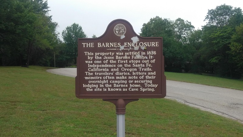
Cave Spring, also known as the Barnes Enclosure, is one of the few remaining physical remnants of the Santa Fe Trail and a local landmark that is connected to leading residents such as Harry S. Truman. The Santa Fe trail connected Independence to traders in the American Southwest, and it passed through Cave Spring allowing travelers to rest and obtain water for themselves and their animals. Jesse Barnes purchased the land that included Cave Spring by the 1840s, but he still allowed pioneers to stay on his land and some even stayed in his home. In later years, Harry S. Truman's grandfather purchased the property, allowing the eventual U.S. President to spend time there as a young man.
Images
Barnes Enclosure and Cave Spring Interpretive Center
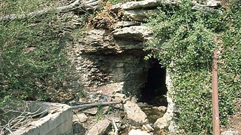
Cave Spring near Raytown, Missouri.
The Barnes Enclosure Historical Landmark near Raytown, Missouri.
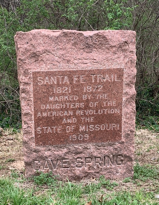
Santa Fe Trail Marker at 72nd and Blue Ridge Blvd.
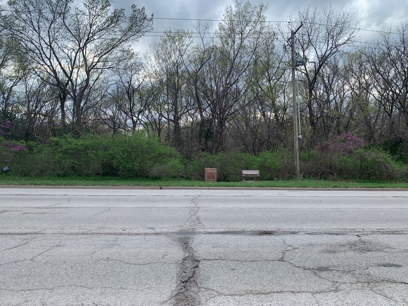
Santa Fe Trail Marker at 72nd and Blue Ridge Blvd.
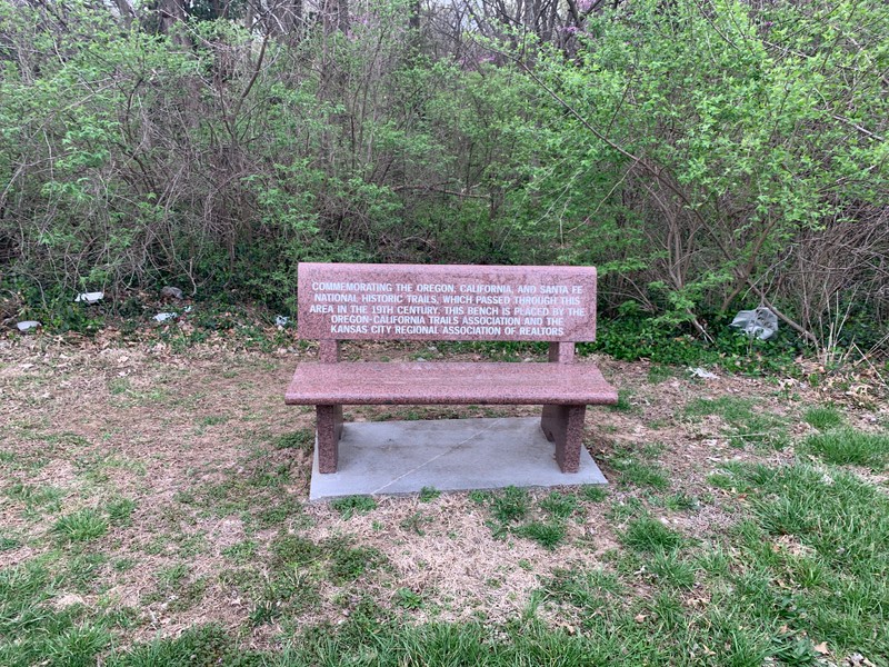
Memorial bench adjacent to the Cave Springs Santa Fe Trail Marker
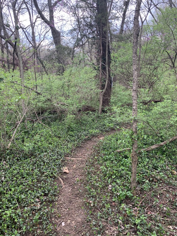
Path from the Cave Springs Park Lake up to the Santa Fe Trail Marker
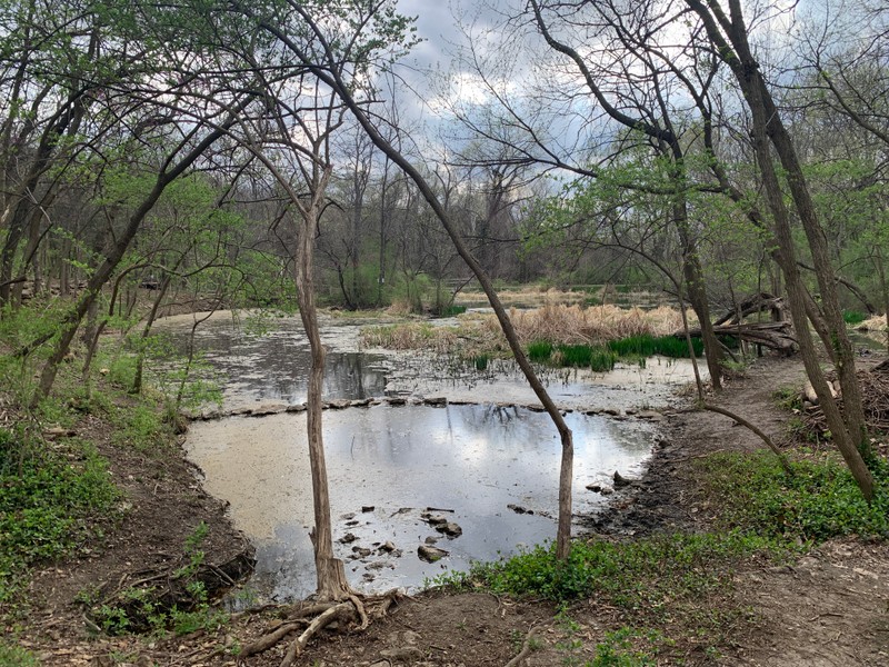
Manmade lake at Cave Springs Park
Backstory and Context
Text-to-speech Audio
The Santa Fe Trail materialized in the early 1820s as a lucrative trade exchange route between Mexico and the United States. The trail benefitted several Missouri towns and regions as they served as starting points for travelers. By 1828, the newly-founded Independence, Missouri, on the Missouri River, evolved into a starting point for the Santa Fe Trail. The town's dominance as a launching point for westward travelers lasted nearly a decade before Kansas City (known as Westport) emerged as a competing location; travelers left from either town until the 1850s. The Independence Trail, or Old Santa Fe Road, crossed through Cave Spring, about ten miles south of Independence. Cave Spring ostensibly functioned as an oasis, or campground, on the trail. Visitors could obtain water for themselves, as well as their cattle and horses, before pushing westward.
Several small farms appeared near the farm, including the historic Barnes' Enclosure, where some westward travelers stayed in the home of its owner, Jesse Barnes. By 1845, the Barnes' Enclosure property included Cave Spring. Barnes moved to Jackson County in 1839 from Kentucky and creatively secured far more property than local laws would otherwise have allowed. When he arrived, laws prohibited anyone from purchasing more than 160 acres of land. However, Barnes acted on the fact that he had four sons about to come of age, at which time each would be eligible for 160 acres. So, he plowed up to 800 acres of land and put up signs proclaiming: "Barnes' Enclosure.
Numerous diaries of those heading along the Santa Fe Trail include entries describing Barnes, his home, and his farmland. Many stayed in his house, while others -- entire wagon trains -- stayed on his land near the springs. Meanwhile, two of Jesse's sons, C.R. and S.S. Barnes, participated in the Santa Fe trade. What is not well understood is the effect Barnes had on the Cave Springs land. Before Jesse Barnes established his farm, people described the unclaimed land around the springs as a prairie land with plenty of timber. Barnes and his sons cultivated land, so one can only surmise the extent of their influence on the local environment.
Nevertheless, even after Jesse Barnes died in 1852, people mentioned staying on the land they called Barnes Springs or Cave Springs. As noted by the National Park Service, "At least two 1846 first-hand accounts mention the Barnes Enclosure-Cave Spring. Susan Shelby Magoffin, one of the first women to travel along the Santa Fe Trail to Mexico, wrote in her diary of "traveling with her husband, Captain Magoffin, a trader, and spending the night in the Barnes home. Also, in a letter to his sister, William Glasgow, a Santa Fe trader, stayed overnight with the Barnes in 1846. A few days later, Susan Magoffin and her maid also stayed overnight with the Barnes Family. Magoffin's diary also mentions meeting these brothers on the trail." Although, traffic through Cave Spring diminished significantly by the mid-1850s as Kansas City (Westport) arose as the preferred launching point to the West.
The Barnes family owned the property until 1859, when it passed to Col. James Chiles, a Kentucky native who suffered severe injuries during the Seminole War in Florida in 1837. He came to Jackson County in 1832 and relied on slave labor to develop a large plantation. He also served several terms in the state legislature. He owned the Barnes land from 1859 to 1861, although his family (some of whom served in the Confederate Army) had connections to the property through the early 1870s. Finally, in 1881, Harry. S. Truman's grandfather purchased at least a portion of the land; accounts exist of Truman spending time at Cave Spring.
Since the late nineteenth century, the property has passed from owner to owner. Although a few homes appeared from time to time, and at least one owner attempted to develop the land into a resort property, the only extensive development came during the 1920s and '30s when a family opened a country club and golf course on the property, which operated until the late 1940s. After its closure, the construction of a new church revealed the spring again, starting efforts to leave the spring and caves unaltered. Although the spring's flow has decreased significantly, likely due to both anthropogenic and natural influences, its survival provides onlookers with a glimpse of what the area looked like to travelers about to embark on a lengthy journey to the American Southwest.
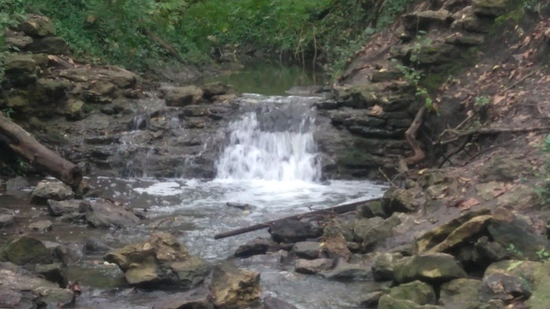
Today it is located within Cave Spring Park at 8701 Gregory Blvd. in Kansas City, Mo. The park contains 4.5 miles of hiking trails around a small manmade lake fed by runoff and the spring itself.
Santa Fe Trail Marker
On the eastern boundary of Cave Springs Park at Blue Ridge Blvd. and E. 72nd Street stands one of 29 Santa Fe Trail Markers erected by the Missouri Chapters of the Daughters of the American Revolution to trace the route of the trail through the state of Missouri. This marker was dedicated without fanfare on May 17, 1909. A small path leads up from the lake to the marker on Blue Ridge Blvd.
History of the Missouri DAR Santa Fe Trail Markers
In 1906-1907, as the work of the Kansas Chapters of the Daughters of the American Revolution that traced the route of the Santa Fe Trail in Kansas was making national news, the Kansas City chapter of the organization began having discussions about memorializing the trail in Missouri. The Kansas City DAR chapter had already commissioned one marker in 1905 to mark the route of the trail as it passed through Penn Valley Park. Now they proposed placing a series of red granite markers, similar to the ones in Kansas, to trace the trail from its origin in Old Franklin, Mo. to the town of New Santa Fe on the Kansas/Missouri state line.
At the state conference in October 1908, a motion was made that the Missouri DAR chapters would work together on the project. A committee of members from Kansas City was delegated to manage the project and choose the locations for the markers. The head of the committee was Hope Van Brunt, whose husband John was the Kansas City architect who had designed the marker in Penn Valley Park.
The Kansas City DAR began by compiling available sources to map the original route of the trail, much of which had been forgotten. They consulted maps from early Missouri and spoke to “old settlers” who had once worked on the trail and could suggest historic locations to mark. By February 1909, their map was complete, and they had picked out 34 locations of historical significance along to trail, where they wanted to place markers. They now began lobbying the Missouri State Legislature for $4000 to fund the project. A year later, the legislature took up the proposal and appropriated $3000 for the project. However, bureaucratic delays prevented the money from being released and the appropriation expired. The legislature appropriated the money again in March 1911 and after another year’s delay the DAR was finally able to order the markers.
In the end, the DAR was able to place 29 markers. The 7’ tall markers are made of Missouri Rose Granite from the Saint Francois Mountains. They each weigh over a ton. Several arrived in 1912, and were placed in Independence, Lexington, Marshall, Arrow Rock and Old Franklin. The rest were installed and dedicated in May 2013.
Sources
"Cave Spring." Raytown Chamber of Commerce. Accessed April 21, 2022. https://raytownchamber.com/cave-spring/.
Denny, James M. "Nomination Form: Cave Spring." National Register of Historic Places. nps.gov. 1976. https://mostateparks.com/sites/mostateparks/files/Cave%20Spring.pdf.
Sanchez, Michael E. Jr. "The Barnes Enclosure." The Historical Marker Database. HMdb.org. September 30, 2019. https://www.hmdb.org/m.asp?m=140275.
"Santa Fe National Historic Trail: Barnes Enclosure and Cave Spring Interpretive Center." National Park Service. Accessed April 21, 2022. https://www.nps.gov/places/barnes-enclosure-and-cave-spring-interpretive-center.htm.
"33 Monument Sites Chosen." Kansas City Journal (Kansas City, Mo.) October 30th, 1912. .10.
"For a Santa Fe Trail Marke." Kansas City Post (Kansas City, Mo.) March 4th, 1909. .2.
"Marking Santa Fe Trail." Kansas City Journal (Kansas City, Mo.) May 16th, 1913. .1.
"Honor Old Trail Marker." Kansas City Star (Kansas City, Mo.) April 27th, 1913. .7.
"30 Santa Fe Trail Markers Are Dedicated." Kansas City Post (Kansas City, Mo.) May 17th, 1913. .
"More Markers For the Trail." Kansas City Star (Kansas City, Mo.) February 12th, 1909. .2.
"Marking the Santa Fe Trail." Kansas City Journal (Kansas City, Mo.) February 13th, 1909. .3.
"The Old Trail to be Marked." Kansas City Star (Kansas City, Mo.) March 20th, 1911. .1.
National Park Service Photo. https://www.nps.gov/places/barnes-enclosure-and-cave-spring-interpretive-center.htm
Photographed By Michael E Sanchez, Jr., September 28, 2019. https://www.hmdb.org/m.asp?m=140275
Photographed By Michael E Sanchez, Jr., September 28, 2019. https://www.hmdb.org/m.asp?m=140275
Photo courtesy of Chris Wolff
Photo courtesy of Chris Wolff
Photo Courtesy of Chris Wolff
Photo Courtesy of Chris Wolff
Photo Courtesy of Chris Wolff