Huntington Dam / Roush Lake
Introduction
Text-to-speech Audio
J. Edward Roush Lake (previously called Huntington Lake) is a flood control reservoir opened in 1967 that allows for boating, fishing, canoeing, kayaking and paddle boating. The surrounding park provides for terrestrial interactions with nature such as camping, hiking, hunting, picnicking and snowmobiling.
Images
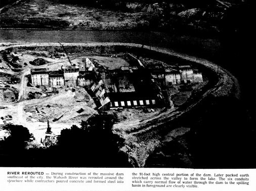
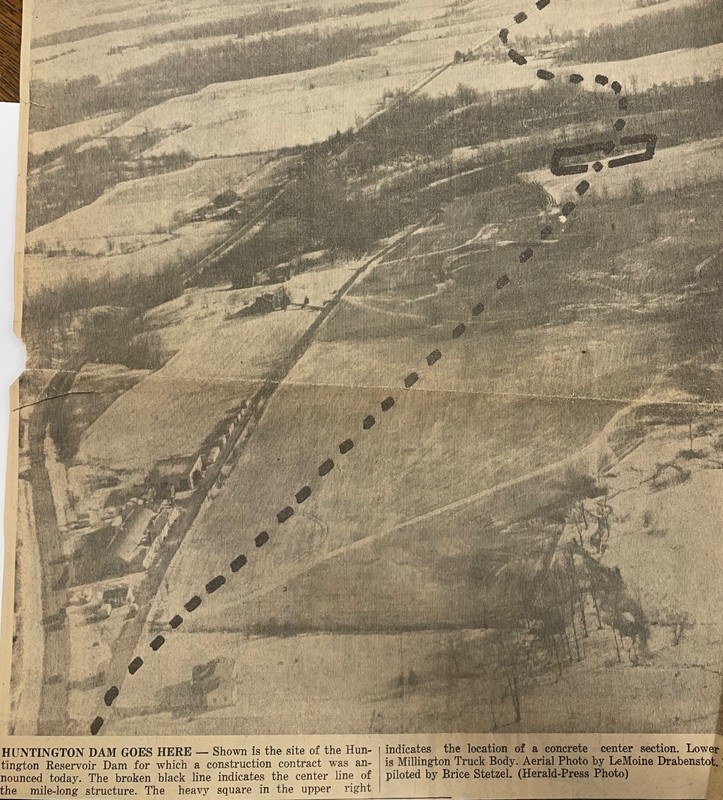
Wabash River Rerouted for Dam Construction
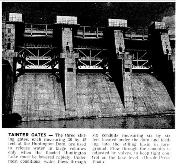
Huntington/ Roush Dam
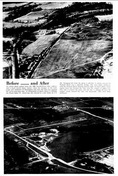
Before and After Building the Dam
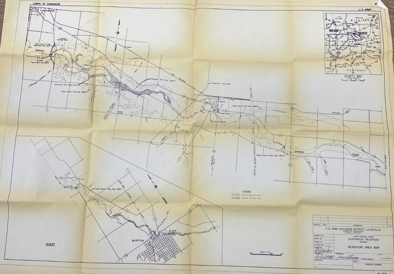
Map of Proposed Affected Area
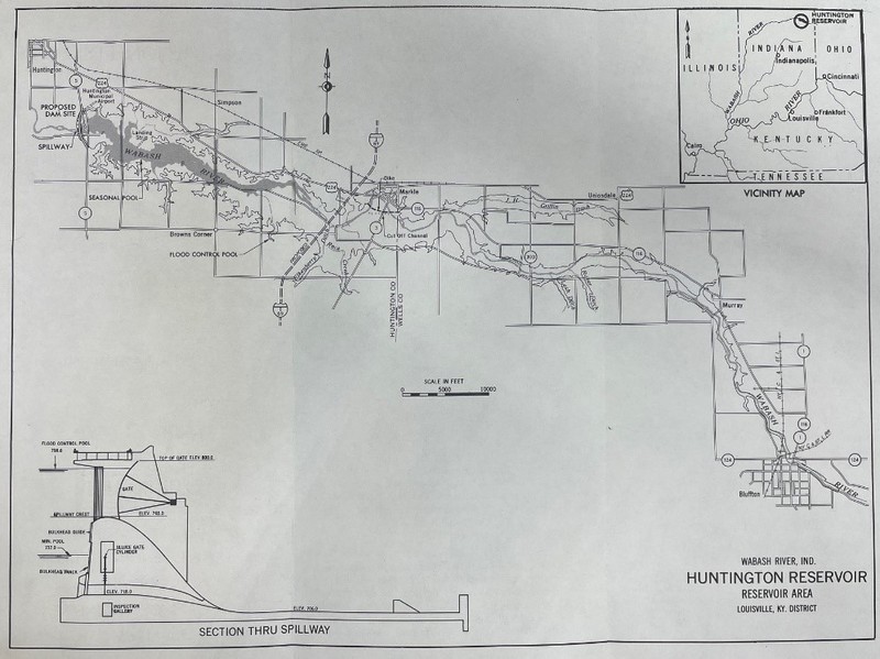
Map of Planned Affected Area
Map of Dam Location on Pre-Dam Aerial
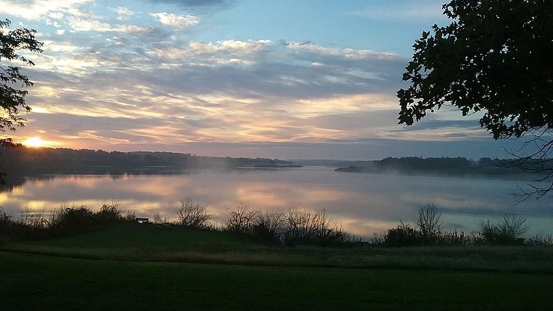
Sunrise Over Roush Lake
Backstory and Context
Text-to-speech Audio
A lake and a reservoir are frequently used as interchangeable terms, however a reservoir is a man-made lake created by a dam on a river, backing up the water and creating a reservoir. The Huntington dam was one part of three Upper Wabash reservoir projects selected for construction under the Flood Control Act of 3 July 1958. Ground breaking began in June of 1965. Work was completed and the dedication ceremony in June 1971 included dignitaries, rolls and coffee and barbeque chicken.
In July 1997, a dedication ceremony was held to rename Huntington Lake, J. Edward Roush Lake. Mr. Roush was a member of the House of Representatives. A large focus, of his time in Congress, was promoting and securing financing for the Mississinewa, Salamonie and Huntington reservoir flood control and recreation projects. Attending primary and secondary school in Huntington as well as Huntington College, this project was of special importance to him. He was also an advocate for a nation-wide emergency telephone number that lead to the 911 program we have now.
In 2010/2011, the management of the J. Edward Roush Flake changed from state management by the Division of State Parks and Reservoirs to being managed by the Division of Fish and Wildlife. To the chargrin of many locals, this change made the area a fish and wildlife focus instead of a recreational area. With this change came the elimination of swimming, the Little Turtle Campground (but the smaller Kil-So-Quah campground remains), mountain bike trails, model plane airport and some pavilions. It did increase the ability to hunt, fish, boat and hike. For fishing, bluegill, largemouth bass, small mouth bass, catfish and crappie can all be found. Hunting includes furbearers (woodchucks not included), deer, rabbit, squirrel, waterfowl, dove, pheasant, and wild turkey.
Admission is free to the J. Edward Roush Fish and Wildlife Area, however a fishing or hunting license is required if taking part in those activities. And, a cash fee is involved to camp.
Sources
- JE Roush Lake Fish & Wildlife Area. In.gov. Accessed 26 May 2022 https://www.in.gov/dnr/fish-and-wildlife/properties/je-roush-lake-fwa/
- J. Edward Roush Lake Dedication Ceremony handout. Material located at the Huntington City-Township Public Library. hctpl.info.
- “As Outdoor Season Starts, Roush showing changes in state status”, The Tab [Huntington In], 12 May 2011.
- “Roush Lake Controversy”, The Herald-Press [Huntington, IN] 17 August 2010.
- Lakes & Reservoirs, usgs.gov, accessed 27 May 2022. https://www.usgs.gov/special-topics/water-science-school/science/lakes-and-reservoirs
- “All Clear for Dam Program” The Herald- Press [Huntington IN], 1971.
- Special Insert, Huntington Herald-Press, [Huntington, IN] 18 Jun 1971.
Herald-Press Article in HCTPL Library History Folder
Herald-Press Article in HCTPL Library History Folder
Herald-Press Article in HCTPL Library History Folder
Army Corps of Engineers Map in HCTPL Library History Folder
Army Corps of Engineers Map in HCTPL Library History Folder
Herald-Press Article in HCTPL Library History Folder
Army Corps of Engineers Photo from Park Website