1878 Army Corps Of Engineers Rest Lake Dam Site
Introduction
Text-to-speech Audio
Exploration of documents from a 1878 Army Corps of Engineers survey reveals that the Manitowish Waters chain of lakes was to be much larger! Today, the modern Rest Lake Dam raises water levels about eight feet above the above the original water level, but the Army Corps of Engineers had designed a dam for Rest Lake that would hold back 25 feet of water. Most residents and visitors are unaware of this plan and have a difficult time imagining lake levels being 17 feet higher than today. 19th Century river drive loggers required dams to facilitate driving white pine logs down stream each spring. The Rest Lake dam site on what is today the outlet of Vance Lake was considered to be among the best dam sites on the Chippewa River watershed. Ultimately, a different dam site was selected just up stream, which held back a maximum of 16 feet of water and required much less labor and materials.
Images
1878 map from Allen Survey of the upper Chippewa, Flambeau, Manitowish, Turtle and Bear Rivers.


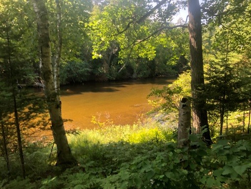
Modern Site for the proposed Rest Lake Dam of 25 feet
House of Representative cover page that included Allen Survey

1878 detailed map of Rest Lake form Allen Survey with arrow marking original dam site

1878 detailed map of Rest Lake form Allen Survey

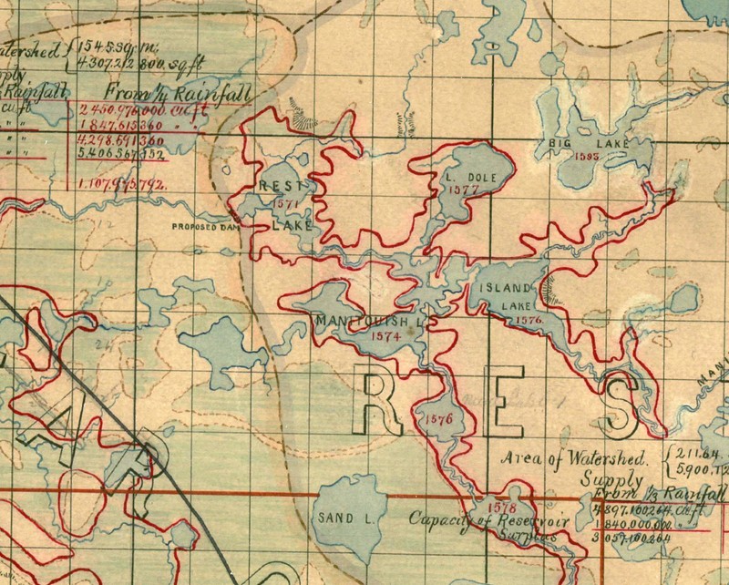
1878 map from Allen Survey of the MW Chain of Lakes; note the red line that indicates the new shores if the 25 foot dam was built
Backstory and Context
Text-to-speech Audio
In 1878, the Army Corps of Engineers conducted a series of surveys along to the Chippewa River to facilitate dam construction mostly for phase 1 river drive logging and flood control. Captain Charles Allen led these surveyors, but his assistant Mr. J. H. Dager led the survey for the Rest Lake Dam. Dager and his men proclaimed the Rest Lake dam site as excellent, able to hold back 25 feet of water. Interestingly, after extensively researching and documenting a 25-foot head of water at the original dam site located a few meters downstream of the outlet of Vance Lake, the U.S. Congress changed the height of the dam to 15 feet in 1880. Ultimately, the dam was moved upstream to its present location at the outlet of Rest Lake, likely because a local resident like Peter Vance might have suggested the goal of a 15-foot dam could be achieved at the modern Rest Lake outlet site with a fraction of the construction.
Early surveys suggest that river drive white pine logging began in the Manitowish Waters in the 1860s.. These logging operations were likely conducted by wildcat loggers without formal property rights, committing timber trespass. Small teams of loggers cut logs close to rivers and lakes, created crude dams, and drove logs down the Manitowish River to mills along the lower Chippewa River. Smaller logging operations continued to log the Manitowish Waters area until Fredrick Weyerhaeuser's "syndication” of lumber and log driving corporations built the Rest Lake Dam and logging camp. Other legitimate river drive logging groups did conduct honest lumber operation and drives, but required Weyerhaeuser's large reservoirs to move their white pines to market.
Pressure from the lumber interest expedited government hydrology studies, Army Corps of Engineers projects, and authorization of dam construction. The resulting dams created new impoundments or reservoirs throughout Wisconsin. These impoundments proved to be vital to all phases of logging in the Northwoods. Phase 1 river drive loggers need the water to drive millions of linear feet of timber down Wisconsin rivers to be processed and sold. Phase 2 railroad logging benefited less but still used reservoirs to float timber like red pines to railroad hoists. While Phase 3 pulpwood logging sometimes used waterways to drive logs, the reservoirs proved vital to control water flow to the new pulpwood mills that lined Wisconsin's rivers.
Today, folks in Wisconsin often refer to these old logging reservoirs as "flowages,” providing amazing recreational benefits. These legacy flowages have added to the many natural lakes that define the northern part of the state. Turtle Flambeau, Chippewa and Willow are but a few of the remnant flowages that provide spectacular outdoor recreation and huge opportunities for commerce. The Department of Natural Resources has worked to create a property designation of Scenic Waterways to preserve and manage several of these impoundments. Importantly, these modern waterways began with early dams for logging.
Sources
Gates, Paul Wallace. The Wisconsin Pine Lands of Cornell University. The State Historical Society of Wisconsin: Madison. 1943.
Interview. Craig Moore. Eagle River Historical Society Museum. Eagle River, WI 12-21-2017.
https://mwhistory.org/2016/wp-content/uploads/2017/01/Allen-selected-journal-1878-1879-new-1.pdf.. Selections from Captain C. J. Allen Journal House of Rep. 45 Congress 1878-1879. Manitowish Waters Historical Society. Retrieved 2-3-18.
https://mwhistory.org/menu-page-for-maps-and-journals/maps-folder/original-survey-maps-from-the-manitowish-waters-area-1860s/manitowish-waters-42-05-east-1862/. Original Survey maps and note books. 1862. Manitowish Waters Historical Society. Retrieved 2-3-18.
http://dnr.wi.gov/wnrmag/html/stories/2004/feb04/forest.htm. Wisconsin Department of Natural Resources. Randall E. Rohe. Retrieved 1-26-2018.
Captain C. J. Allen Journal House of Rep. 45 Congress 1878-1879
Captain C. J. Allen Journal House of Rep. 45 Congress 1878-1879
Manitowish Waters Historical Society
Captain C. J. Allen Journal House of Rep. 45 Congress 1878-1879
Captain C. J. Allen Journal House of Rep. 45 Congress 1878-1879
Captain C. J. Allen Journal House of Rep. 45 Congress 1878-1879
Captain C. J. Allen Journal House of Rep. 45 Congress 1878-1879