Banquo (Ghost Town)
Introduction
Text-to-speech Audio
Banquo may not have been platted until 1906, but even before then it was a thriving hamlet operating under several names. It was the largest settlement in Wayne Township. It had post offices under three different names: Price (1849-1861), Priceville (1871-1874), and Banquo (1887-1903). Since 1903 Banquo has received its mail from the LaFontaine post office in Wabash County. In 1906 it had two general stores, the post office, a blacksmith shop, tile mill, and doctor's office.
The school located in the village operated from before 1866 until 1966. The high school portion closed in 1955. Since then, the village has been slowly shrinking. Today there is a church, a farm market, and a number of homes.
Images
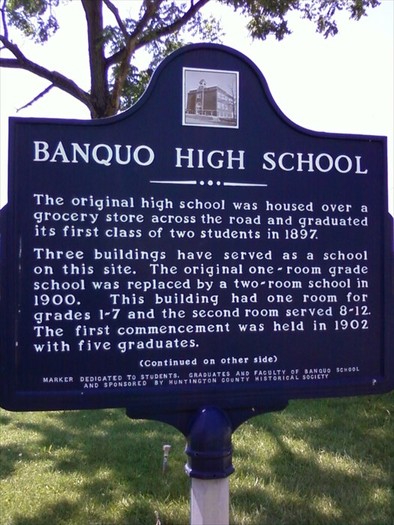
Banquo High School Memorial Marker
Modern Aerial of Banquo
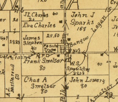
Banquo on the 1903 Huntington County Map.
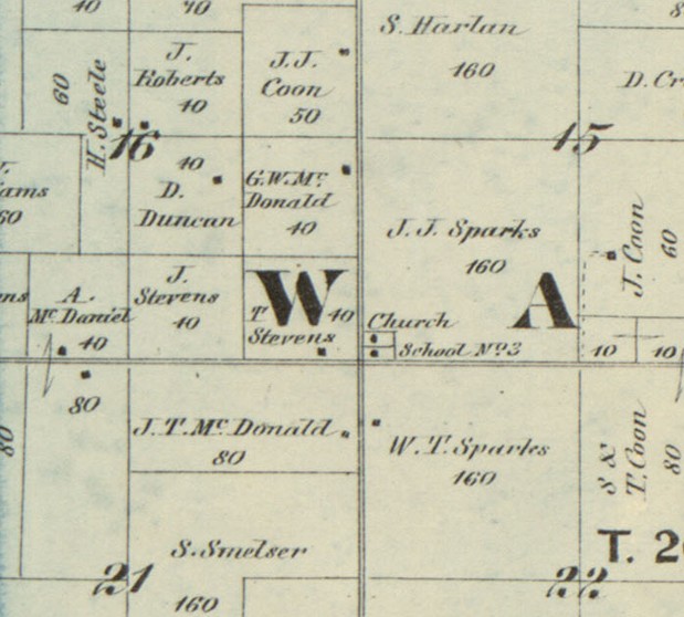
Banquo on the 1866 Huntington County Map.
Backstory and Context
Text-to-speech Audio
According to tradition, Banquo takes its name from the ghost in Shakespeare's play MacBeth. This is possibly due to a nearby ghost story at the time.
Before 1866 the place that was to become Banquo had a church and Wayne township district school #3. At first it was a district (one-room) school, but in 1894 or 1895 the township organized a high school with classes held above the grocery store. In 1900 the township built a larger school on the site of the district school, with grades 1 - 12. The high school survived until 1955 when students were transferred to other schools in the county. The grade school closed in 1966 and the building was torn down in 1969. A marker now memorializes the school.
In 1911 a separate building was constructed by a group of young men in order to play basketball. The building was 60 by 50 feet with a court 10 feet less in each direction. It had a saw dust floor and coal oil lamps (later changed to gas). Later used for the school gymnasium, it is believed to have been the first purpose-built building for basketball in the state, and perhaps the nation.
Banquo first appears as a labelled place on the 1895 county map. It still appears on plat maps and Google Maps. By 1879, the church disappears, but a medical doctor has moved into a home on the south of the hamlet. In 1903 there are two churches, the Rushcreek Baptist church on the south side of town which is long defunct, and the Banquo Christian Church organized in 1900 and still active. When it was platted in 1906, Banquo had 17 lots.
An interesting fact is that despite its long history with churches, there is no record of Banquo ever having a cemetery of its own. The closest active cemetery is the Gardens of Memory on IN- 9 at IN-218 (about 2 ½ miles south).
A Banquo native, John S. Thomas, was the first recipient of the honorary title "Chief of the Flint Springs Tribe" in 1969. The award is for outstanding service to the community and is given out during Heritage Days.
Sources
- Ancestry.com. U.S., Appointments of U. S. Postmasters, 1832-1971 [database on-line]. Provo, UT, USA: Ancestry.com, 2010. Original data: Record of Appointment of Postmasters, 1832-1971. NARA Microfilm Publication, M841, 145 rolls. Records of the Post Office Department, Record Group Number 28. Washington, D.C.: National Archives
- History of Huntington County, Indiana: A Narrative Account. 1914. Frank Sumner Bash. Chicago: Lewis Pub. Co., p152
- Golden Memories of the Banquo School. n.d. (ca. 1970). Jessie Kem.
- Banquo History File in the Keefer Center of the Huntington City-Township Public Library, hctpl.info.
- Huntington County, Indiana History: Township by Township. 2004-2005. Jean Gernand.
- 'Banquo High School.' Historical Marker Database. https://www.hmdb.org/m.asp?m=76439 Accessed 9 Aug 2023
- Map of Huntington Co., Indiana. 1866. Warner, Hayes & Warner. Ligonier, Ind.: E.B. Gerber & C.S. Warner.
- Map of Huntington Co., Indiana. 1895. H. H. Wagoner, Huntington, Ind. (poor photocopy)
- Huntington County, Indiana. 1903. Herman Taylor, Warsaw, Ind.: National Map Co. Rockford, Ill.: Hixson Map & Litho. Co.
- Huntington County, Indiana: History & Families. 1993. Huntington County Historical Society. Paducah, Ky: Turner Pub. p45
- Modern aerial photo. Beacon GIS. https://beacon.schneidercorp.com/ Accessed 9 Aug 2023.
Historical Marker Database, https://www.hmdb.org/m.asp?m=76439
Beacon GIS for Huntington County. Intersection of 900S and IN-105
1903 Huntington County Map
1866 Huntington County Map