Trails Arch Bridge
Introduction
Text-to-speech Audio
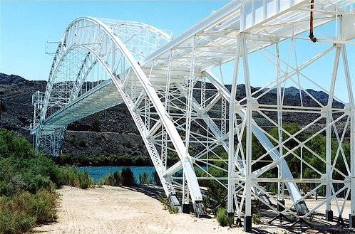
This historic bridge was built in 1916 and was located where the historic Route 66 once traversed the Colorado River. From here, travelers either crossed west into California or east into Arizona. An excellent example of a through-arch bridge, this structure spans 600 feet of riverbed and is 800 feet long. It was the longest bridge in the country until 1928 and is considered a landmark of civil engineering. The bridge now carries a natural gas pipeline and was Listed on the National Register of Historic Places in 1988. The location on the map is the best place to view the bridge.
Images
The Trails Arch Bridge was erected in 1916 and became part of Route 66 in 1926. It was the longest bridge in the country until 1928 and is a civil engineering landmark..
The bridge as seen in the 1920s.

Backstory and Context
Text-to-speech Audio
Before the Trails Arch Bridge was built, people crossed the Colorado River in this area using a ferry service in the town of the Needles. This came to an end in 1914 when a flood destroyed the ferry. Cars were then allowed to cross the river over the Red Rock Railroad Bridge. Planks were placed over the tracks allowing cars to drive over the bridge when trains were not passing through.
After the flood, Arizona, California, the U.S. Bureau of Indian Affairs, and San Bernadino County decided to build the Trails Arch Bridge. The Kansas City Steel Company built it with steel using a cantilever system. It was erected in halves with each half built on their sides then lifted into place. The bridge was first part of the National Old Trails Highway (for this reason the bridge is also known as the Old Trails Bridge) before becoming part of Route 66 in 1926.
A "new" Red Rock Bridge was erected to the north in 1945 and is still used today. Two years later, Route 66 was realigned to the original Red Rock Railroad Bridge, which was reconfigured for car traffic. The next year deck on the Trails Arch Bridge was removed and replaced by the natural gas pipeline that still operates today. The I-40 bridge was built in 1966, rendering the "old" Red Rock Bridge obsolete (it was torn down in 1978).
Sources
Fraser, Clayton B. "Old Trails Bridge (Topock Bridge, Needles Bridge). HABS/HAER Inventory, National Park Service. April 1, 1987. https://npgallery.nps.gov/NRHP/GetAsset/NRHP/88001676_text.
"Trails Arch Bridge." TheRoute 66.com. Accessed September 11, 2023. https://www.theroute-66.com/topock.html#trails-arch.
All images via Wikimedia Comons: https://commons.wikimedia.org/wiki/Category:Old_Trails_Bridge