Confederate Position Tour Stop 5 (Battle of Westport Driving Tour) (Price's Raid)
Introduction
Text-to-speech Audio
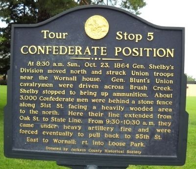
Historical Marker Inscription: At 8:30 A.M. Sun., Oct. 23, 1864, Gen. Shelby's Division moved north and struck Union troops near the Wornall House. Gen. Blunt's Union cavalrymen were driven across Brush Creek. Shelby stopped to bring up ammunition. About 3,000 Confederate men were behind a stone fence along 51st St. facing a heavily wooded area to the north. Here their line extended from Oak St. to State Line. From 9:30 - 10:30 a.m. they came under heavy artillery fire and were forced eventually to pull back to 55th St.
This location is the initial Confederate Position on October 23, 1864, during the Battle of Westport, which was the largest Civil War battle west of the Mississippi River. Some historians have called it “the Gettysburg of the West.” It was also the turning of the tide of Price’s Raid into Missouri. The Confederates lost the battle and retreated back to Texas, with Price’s Army of the Missouri disintegrating along the way. The objective of Price’s Raid was to seize St. Louis and take Missouri for the Confederacy; the Union had been in control of Missouri since early in the war. After the battle, the Union was able to maintain control of most of Missouri for the rest of the war. The marker can be viewed by the stone fence near the intersection of 51st Street and 52nd Street. The marker is a stop on the larger tour of the Battle of Westport and was erected by the Monnett Battle of Westport Fund.
Images
Picture of the Confederate Position Historical Marker
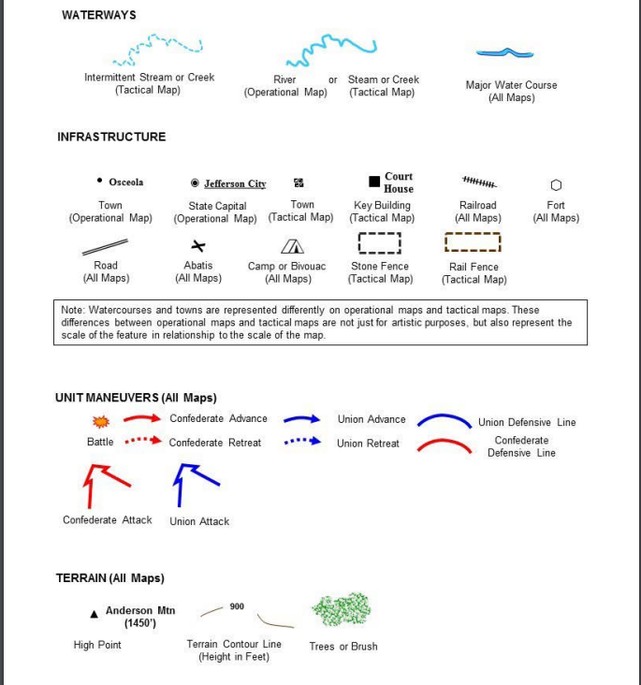
Map Key 1
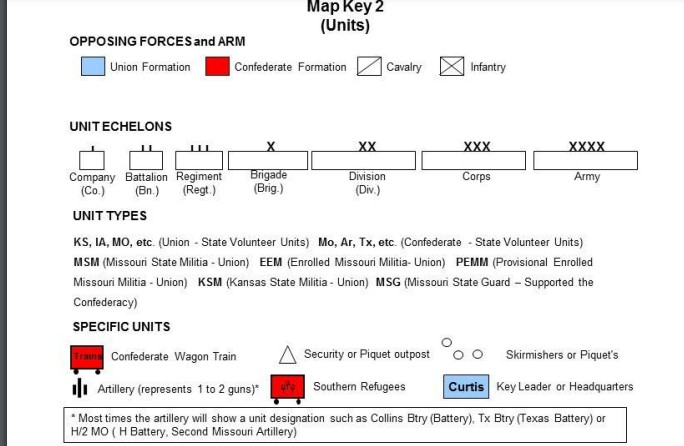
Map Key 2
Battle of Westport Map Initial Positions
Battle of Westport Map Progression
Backstory and Context
Text-to-speech Audio
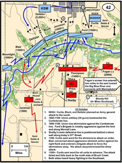
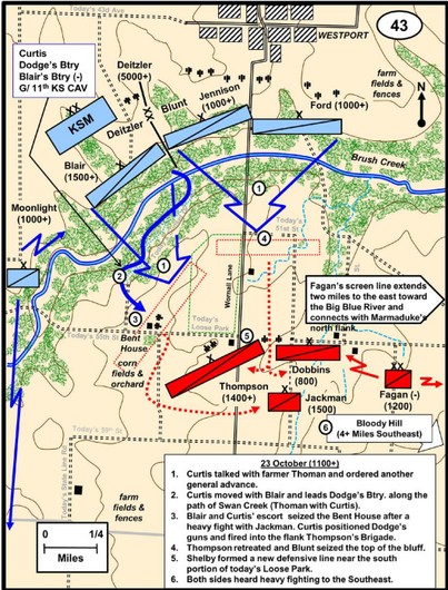
This battle position is significant to a greater understanding of how the Confederates lost the Battle of Westport. Here is how Price’s Army of the Missouri ended up in this specific position. In response to Gen. James G. Blunt’s attack from Westport coming south up Wornall Road (for more information see Union Position marker), Confederate General Joseph Shelby’s and General James Fagan’s Cavalry Brigades counterattacked and pushed Blunt’s forces back to the north side of Brush Creek (the Plaza side), where Blunt’s forces formed a line defending the town of Westport. While pushing the Union forces back, the Confederates had them outflanked and outnumbered. Shelby’s men got as far as the south bank of Brush Creek, but his attack stalled, due to being low on ammunition. So instead of continuing the pursuit, he took up a defensive position along a stone fence along what is now 51st Street. This is how Confederate forces got into the position described in the marker.
Unless they remain stationary while taking cover or holding a position, military formations in battles are typically mobile, often advancing and retreating. Confederates were set up with Col. Sidney D. Jackman’s Cavalry brigade located on the far left near modern day 55th Street and Ward Parkway by the Bent House. His skirmish line caused Union Col. Charles W. Blair to think he was going to be outflanked and he initiated a counterattack that accidentally desynchronized the Union line’s attack. Gen. Shelby’s Cavalry Division was located in the middle on the southeast side of modern day 55th Street and Wornall Road. Price’s Army of the Missouri was to the right in front of Gen. Shelby’s Division, which was covering the rear of Price’s Army. Gen. Thompson’s Brigade was in front of Price along modern day 51th Street and Wornall Road. Thompson’s brigade was also Shelby’s main defensive line. There the men took cover using a stone fence, which protected them from enemy fire. This allowed the Confederates some visual cover as well. The stone fence that the marker is currently in front of is not the same fence that was there during the Battle of Westport, due to its height and use of modern cement. Lastly, Gen. Fagan’s Division was set up in a screen line. A screen is a tactic whereby a smaller contingent of soldiers is used to conceal the size of the main force and serve as reconnaissance and a sort of early warning system. Gen. Fagan’s Division was next to Thompson’s and extended around two miles to the east making it look as though the Confederates had their right flank covered. Most of their men were not actually there, and instead were connected with Col. Marmaduke, who was in the process of losing at Byram's Ford (see Byram's Ford marker)
The Confederates repulsed several Union assaults, causing the Union forces to have to regroup on the north side of Brush Creek. The Union Ford’s Brigade had fought notably hard at Wornall Road earlier in the day, which may have led Shelby, and in turn Thompson, to think the main Union threat was concentrated at this spot. Union Gen. Curtis decided after several failed frontal assaults that he needed a different approach. He ultimately outflanked the Confederates and took the Bent House, eventually winning the battle. (To learn more look at the marker for the Union Flanking Movement at the intersection of Sunset Drive and Rockwell Lane.)
In 1979, the Howard N. Monnett Battle of Westport Fund erected historical markers at 25 significant Battle of Westport sites, as well as a t32-mile self-guided car tour. Several of the markers are within walking distance in Loose Park and the surrounding area, including the Union Flanking Movement marker, the Union Artillery historical marker, and the Battle of Westport Monument. This Confederate Position historical marker stands in front of a stone wall, which is fitting given the quite advantageous defensive role the wall played in the battle.
The Battle of Westport is an important part of both Kansas City and Civil War history. The Confederate Position is crucial to understanding how and why Price’s Army of the Missouri lost the Battle of Westport, and why Price’s Raid failed more broadly. Their logistical and supply problems cost them the battle even with superior positioning. The marker allows people to have easy access to learning about the Battle of Westport, at one of the most popular parks in Kansas City.
Sources
“Civil War on the Western Border: The Missouri-Kansas Conflict, 1854-1865.” Battle of
Westport | Civil War on the Western Border: The Missouri-Kansas Conflict, 1854-1865,
civilwaronthewesternborder.org/encyclopedia/battle-westport. Accessed 12 Nov. 2023.
Civil War Round Table of Kansas City - Monnett Battle of Westport Fund,
cwrtkc.org/monnett_battle_of_westport_fund. Accessed 12 Nov. 2023.
. Collins, Charles D. Army University Press Home, www.armyupress.army.mil/Portals/7/educational-services/staff-rides/StaffRideHB_AtlasofPricesMissouriExpeditionof1864.pdf. Acc
Accessed 12 Nov. 2023.
Confederate position historical marker. Historical Marker. (2023, February 10).
https://www.hmdb.org/m.asp?m=21705
Gerteis, Louis S. The Civil War in Missouri: A Military History. University of Missouri Press,
2015.
Jenkins, Paul Burrill. Battle of Westport. Nabu Press, 2010.
Lause, Mark A. Price’s Lost Campaign: The 1864 Invasion of Missouri. University Of Missouri
Press, 2013.
Lause, Mark A. The Collapse of Price’s Raid: The Beginning of the End in Civil War Missouri.
University of Missouri Press, 2016.
Roe, Jason. “Gettysburg of the West.” KC History, kchistory.org/week-kansas-city-
history/gettysburg-west#:~:text=Curtis%20set%20up%20a%20new,to%20more%20than%2020%2C000%20soldiers. Accessed 12 Nov. 2023.
Photographed By Thomas Onions, August 16, 2009
Collins, Charles D. Battlefield Atlas of Price’s Missouri Expedition of 1864. Fort Leavenworth, KS: Combat Studies Institute, US Army Combined Arms Center, 2016.
Collins, Charles D. Battlefield Atlas of Price’s Missouri Expedition of 1864. Fort Leavenworth, KS: Combat Studies Institute, US Army Combined Arms Center, 2016.
Collins, Charles D. Battlefield Atlas of Price’s Missouri Expedition of 1864. Fort Leavenworth, KS: Combat Studies Institute, US Army Combined Arms Center, 2016.
Collins, Charles D. Battlefield Atlas of Price’s Missouri Expedition of 1864. Fort Leavenworth, KS: Combat Studies Institute, US Army Combined Arms Center, 2016.