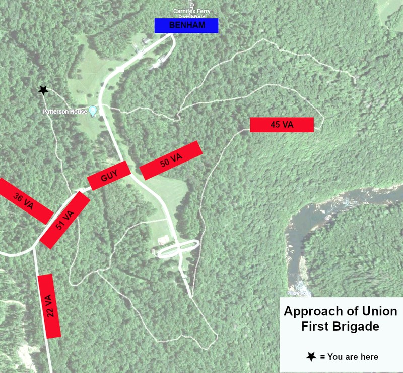
Stop 2: Approach of the Union Troops & Attempts to Attack the Confederate Left
Introduction
Text-to-speech Audio
Leaving Stop 1, walk back on Rt. 23 (away from the main road) until it intersects with the Patterson Trail. Turn right onto the trail and continue until you reach the sharp bend in the trail where it doubles back on itself and begins to go uphill out of the valley.
Images
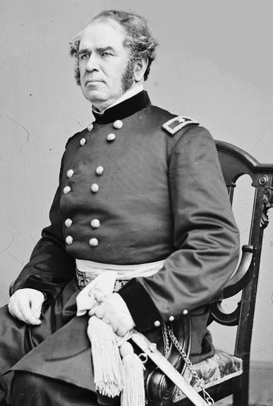
Brigadier General Henry Washington Benham, commanding Union First Brigade
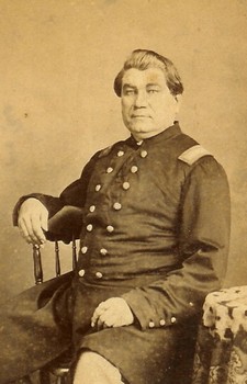
Assistant Adjutant General George Lucas Hartsuff
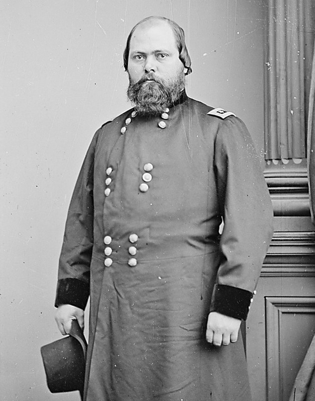
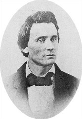
Colonel Robert Latimer McCook, commanding the Union Second Brigade
Colonel Augustus Moor, 28th Ohio Infantry
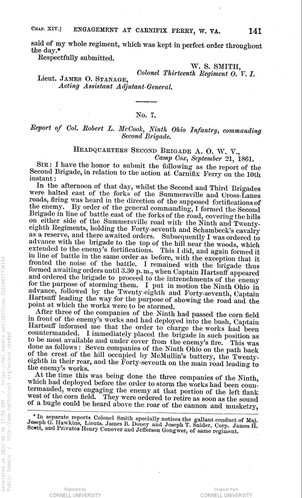
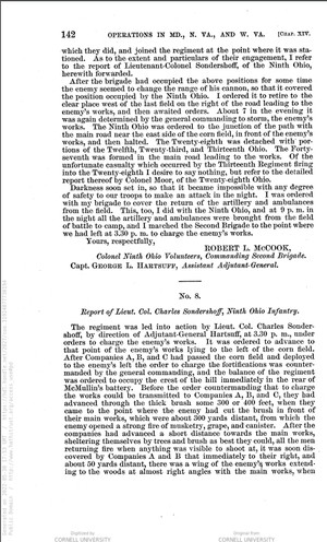
Report of Col. Robert L. McCook, page 1
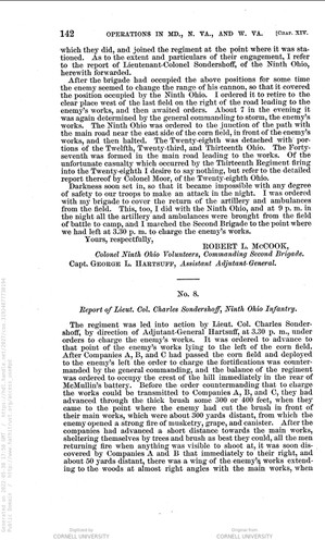
Report of Col. Robert L. McCook, page 2
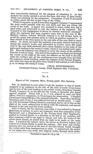
Report of Lieut. Col. Charles Sondershoff, 9th Ohio, page 1
Report of Lieut. Col. Charles Sondershoff, 9th Ohio, page 2
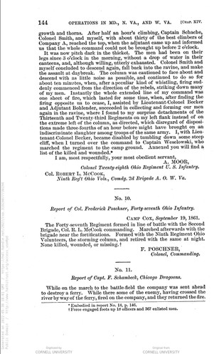
Report of Col. Frederick Poschner, 47th Ohio
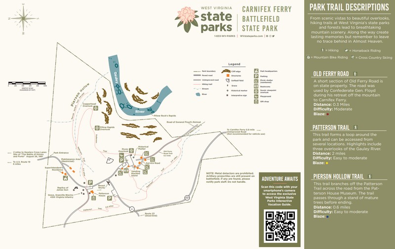
Carnifex Ferry Battlefield State Park Trail Map
Backstory and Context
Text-to-speech Audio
Approach of the Union Column:
Once Rosecrans and his Union column determined that Floyd was not positioned at Cross Lanes as they expected, Rosecrans cautiously moved down the Ferry Road with Brigadier General Henry W. Benham’s First Brigade, specifically the 10th Ohio and 13th Ohio, in the lead. Rosecrans did not know the exact location of Floyd’s force at this point, but around 2:00pm the head of the column came upon the former camp of the 50th Virginia and reported seeing that regiment retreating in the direction of the ferry. Benham requested permission to continue moving forward, and Rosecrans agreed although only ordered Benham to perform reconnaissance. Following the Ferry Road, Benham continued forward with the 10th Ohio in the lead, followed by the 13th Ohio. The Union lines maneuvered through the thick woods until they approached the clearing of the Henry Patterson farm. Union scouts had reported back to Benham that they could see the Confederate fortifications, but Benham did not believe that the Confederates were present in force and continued his men forward.
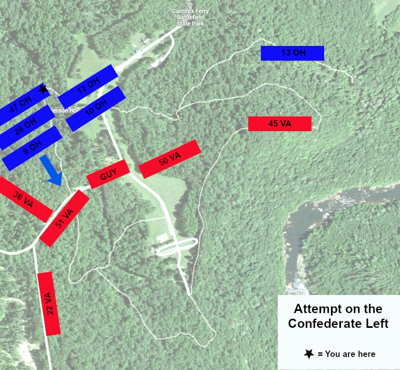
Attempt to attack the Confederate left
**These events occur later in the afternoon, after the events detailed in Stop 3 began.
Face back the way you just came on the Patterson Trail. You are facing the direction of the Union movement towards the Confederate center and left. The Confederate line is approximately 0.2 miles in front of you.
Once Benham’s First Brigade was engaged Rosecrans ordered the Second and Third Brigades up from where they were in reserve just east of the Cross Lanes/Summersville intersection. Rosecrans ordered the Second Brigade commanded by Colonel Robert L. McCook into battle lines. The 9th Ohio (commanded by Lieutenant Colonel Charles Sondershoff) was on the right with its left flank on the road and the 28th Ohio (commanded by Colonel Augustus Moor) was on the left. The 47th Ohio (commanded by Colonel Frederick Poschner) formed a second line and the Chicago Dragoons remained in the rear.
As the Second Brigade moved to the front, Assistant Adjutant General George Hartsuff developed a plan to assault the Confederate left. He located a ravine that could provide cover for an advance on the main Confederate battery while it was still focused on engaging with the First Brigade to their front. Presenting his strategy to Rosecrans, Hartsuff was given the Second Brigade to undertake his plan. McCook and Hartsuff moved the brigade into the woods to the right of the Patterson clearing and positioned them for the assault. The 9th Ohio was the first line, the 28th Ohio was the second line, and the 47th Ohio was the third line.
After the Second Brigade was in position, Rosecrans second-guessed the planned assault. He did not have good intelligence on the full position and strength of Floyd’s line and he did not want to throw the brigade into an unknown situation. Rosecrans called off the attack, but before the orders reached all of the Second Brigade units three companies had already moved forward. Companies A and B moved forward on the right and discovered the second line of Confederate breastworks that branched off the main position at almost a right angle (this was the forward line held by the 36th Virginia). Company C moved forward through the cornfield and came within 100 yards of the Confederate breastworks before all three companies heard the signal to fall back. With their assault called off, McCook pulled the Second Brigade back to a position behind the crest of the hill to wait for new orders.
Sources
Lesser, W. Hunter. Rebels At the Gate: Lee and McClellan on the Front Line of a Nation Divided. Naperville, IL: Sourcebooks, Inc., 2004.
Lowry, Terry. September Blood: The Battle of Carnifex Ferry. Charleston, WV: Quarrier Press, 2011.
Shaffer, Dallas B. “The Battle at Carnifex Ferry.” State of West Virginia. Produced by the Department of Natural Resources, Division of Parks and Recreation. C. 1963.
Snell, Mark A. West Virginia and the Civil War: Mountaineers Are Always Free. Charleston, SC: The History Press, 2011.
Stutler, Boyd B. West Virginia in the Civil War. Charleston, WV: Education Foundation, Inc, 1966.
"Henry Washington Benham." Wikipedia. Accessed May 27, 2022. https://en.wikipedia.org/wiki/Henry_Washington_Benham.
Base maps from Google Maps. Edited by Kathleen Thompson.
"George Lucas Hartsuff." Wikipedia. Accessed May 27, 2022. https://en.wikipedia.org/wiki/George_Lucas_Hartsuff.
Base map from Google Maps. Edited by Kathleen Thompson.
"Robert Latimer McCook." Wikipedia. Accessed May 27, 2022. https://en.wikipedia.org/wiki/Robert_Latimer_McCook.
"Augustus Moor." Find A Grave. Accessed May 17, 2022. https://www.findagrave.com/memorial/5951261/augustus-moor.
The War of the Rebellion: A Compilation of the Official Records of the Union and Confederate Armies. Series 1, volume 5, pages 141-142. Accessed May 30, 2022. https://babel.hathitrust.org/cgi/pt?id=coo.31924077730194&view=1up&seq=158.
The War of the Rebellion: A Compilation of the Official Records of the Union and Confederate Armies. Series 1, volume 5, pages 141-142. Accessed May 30, 2022. https://babel.hathitrust.org/cgi/pt?id=coo.31924077730194&view=1up&seq=158.
The War of the Rebellion: A Compilation of the Official Records of the Union and Confederate Armies. Series 1, volume 5, pages 142-143. Accessed May 30, 2022. https://babel.hathitrust.org/cgi/pt?id=coo.31924077730194&view=1up&seq=158.
The War of the Rebellion: A Compilation of the Official Records of the Union and Confederate Armies. Series 1, volume 5, pages 142-143. Accessed May 30, 2022. https://babel.hathitrust.org/cgi/pt?id=coo.31924077730194&view=1up&seq=158.
The War of the Rebellion: A Compilation of the Official Records of the Union and Confederate Armies. Series 1, volume 5, pages 144. Accessed May 30, 2022. https://babel.hathitrust.org/cgi/pt?id=coo.31924077730194&view=1up&seq=158.
Carnifex Ferry Battlefield State Park. Accessed May 30, 2022. https://wvstateparks.com/wp-content/uploads/2020/09/CarnifexFerryBattlefieldStateParkMap.pdf.