The Point/Wager Ferry Lot Reservation
Introduction
Text-to-speech Audio
The land known as the Point was part of Robert Harper's land in the 1700s. When the U.S. Government purchased the surrounding acreage for the Federal Armory, Sarah and John Wager retained ownership of this piece of land and the ferry crossing. Between 1815 and 1860, this was a bustling residential and commercial area, but all of the structures were destroyed during the Civil War. After the war, the Point was the crossroads for railroad and highway bridges until the 1936 flood destroyed the two vehicle bridges.
Images
The Point
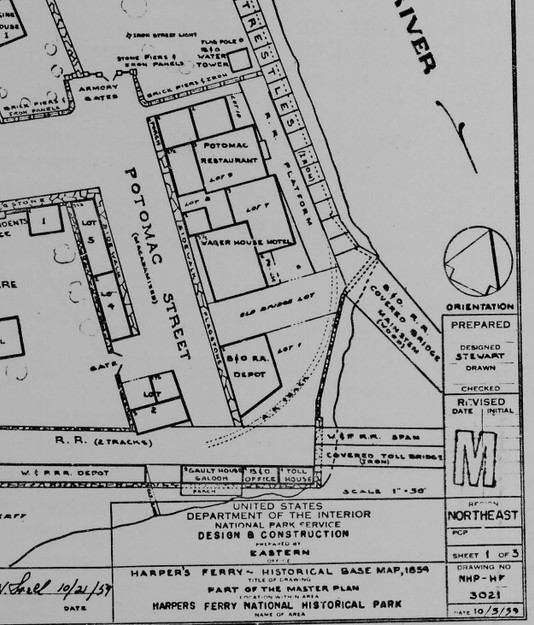
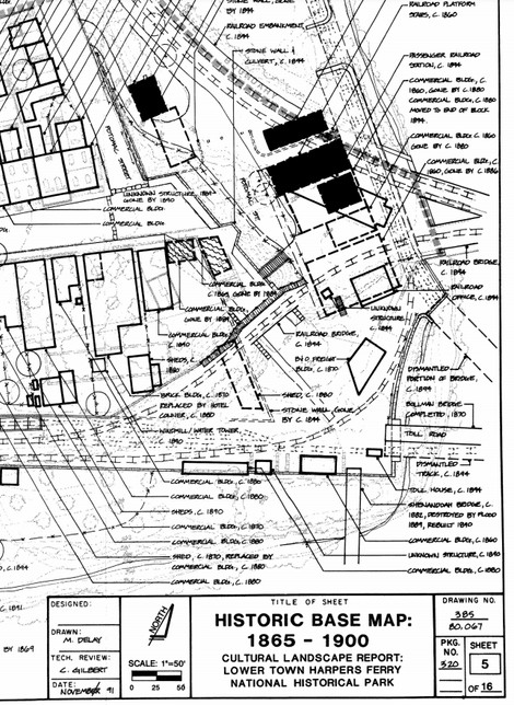
Wager Ferry Lot Reservation from Historical Base Map, 1859
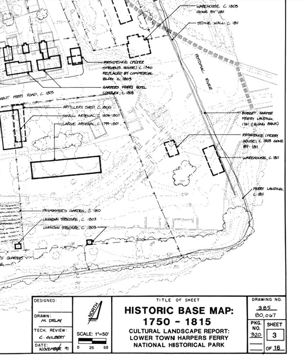
Wager Ferry Lot Reservation, 1750-1815
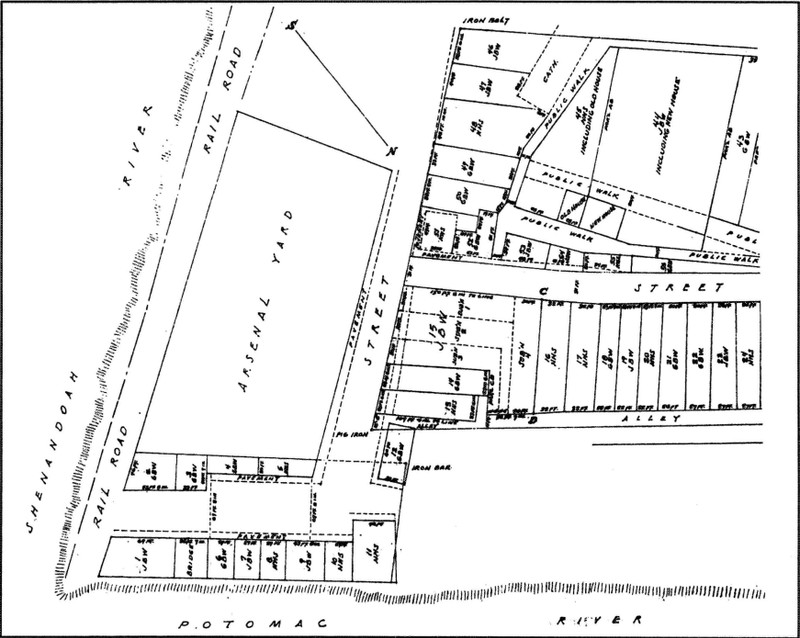
Plat map for Wager Ferry Lot, 1835
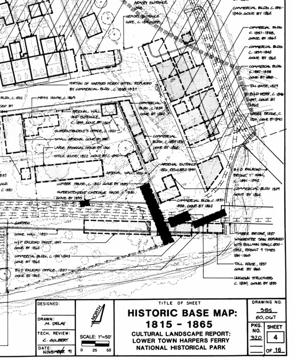
Wager Ferry Lot Reservation, 1815-1865
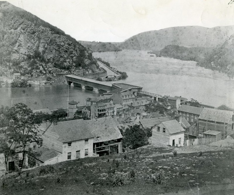
1859 view of Lower Town and the Wager Ferry Lot by the B&O Railroad Bridge.
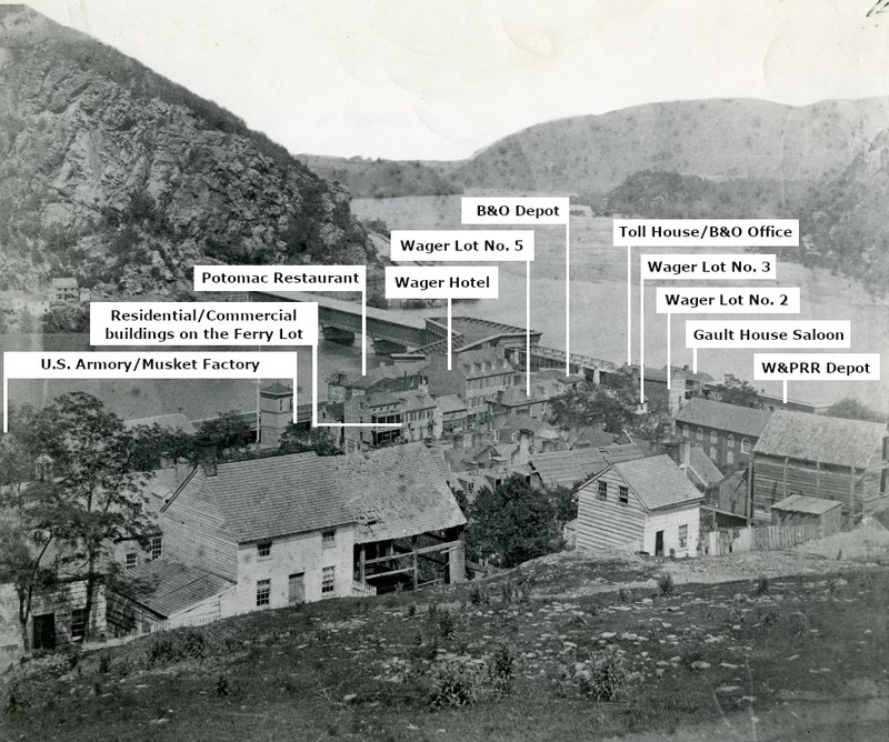
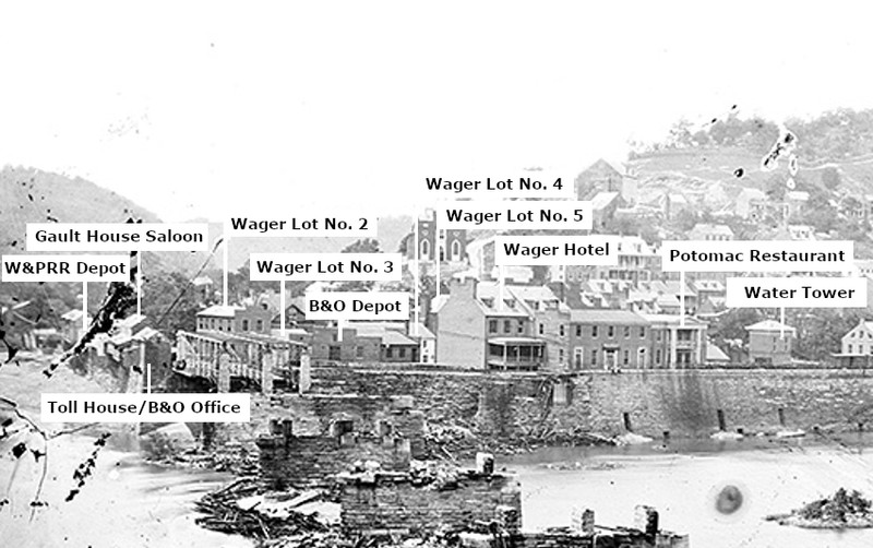
Labeled 1859 view of the "Point."
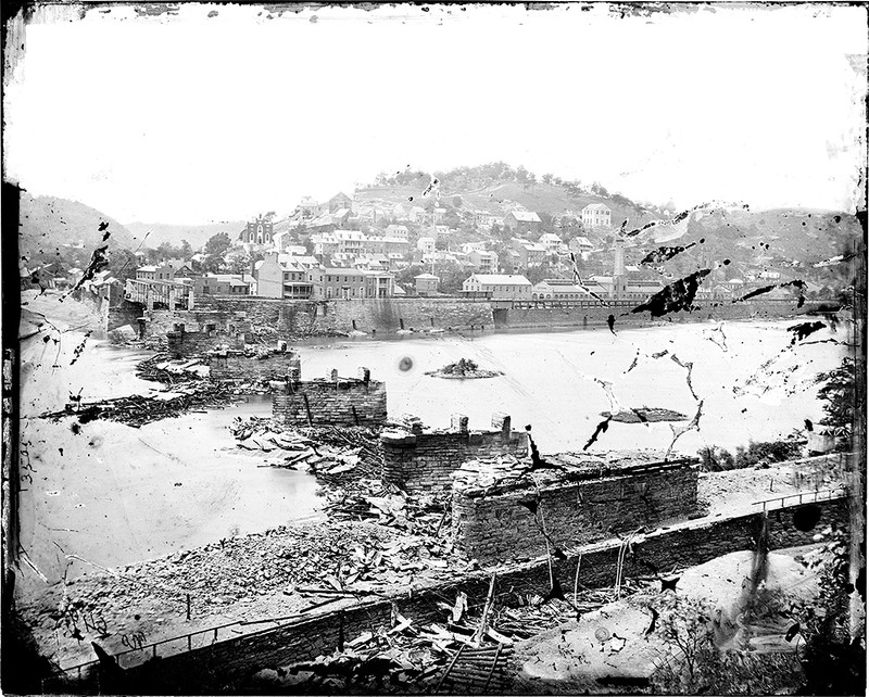
View of the Wager Ferry Lot between June 14, 1861 when Confederates destroyed the B&O Railroad Bridge and February 7, 1862 when Union troops burned the buildings at the Point
Labeled portion of 1861-1862 view of the Point.
Wager Ferry Lot Reservation, 1865-1900
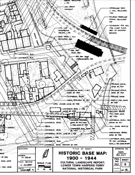
Wager Ferry Lot Reservation, 1900-1944
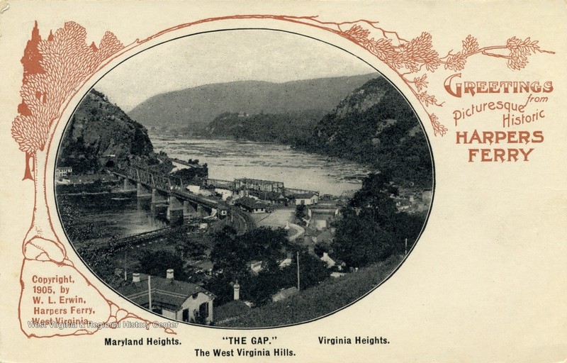
"The Gap at Harpers Ferry, W. Va.", c. 1905
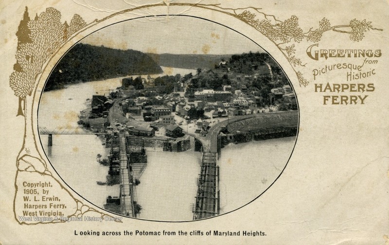
"Looking Across the Potomac from the cliffs of Maryland Heights," c. 1905
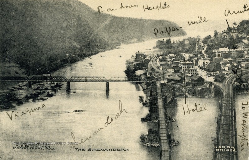
"Harpers Ferry from Maryland Heights," c. 1906
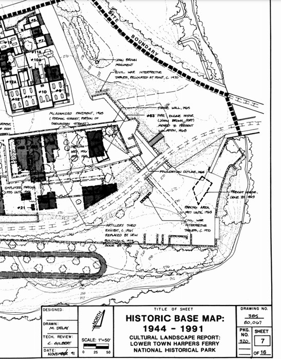
Wager Ferry Lot Reservation, 1944-1991
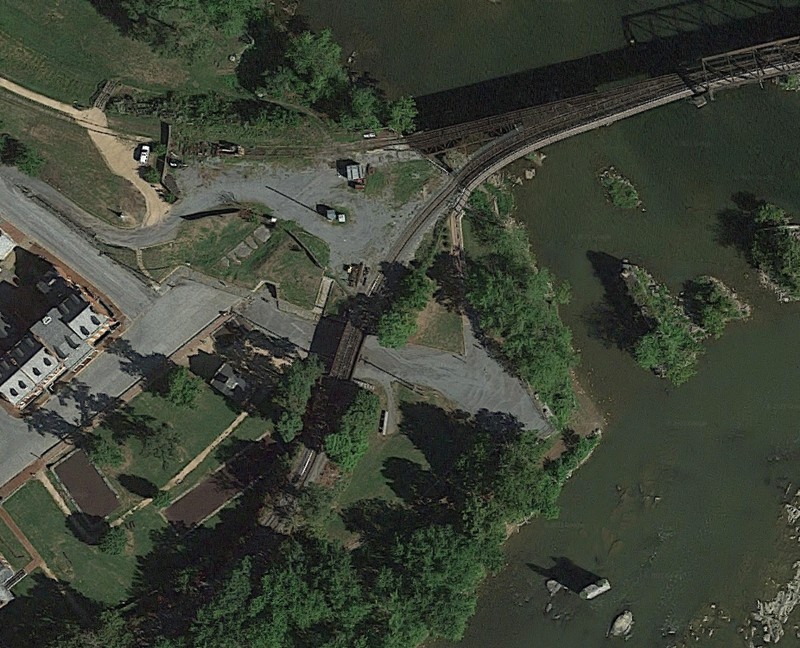
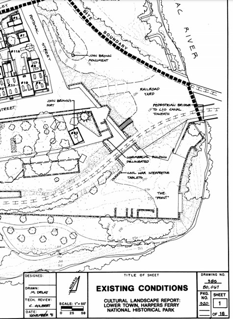
Wager Ferry Lot Reservation, current conditions
Backstory and Context
Text-to-speech Audio
Robert Harper first arrived at the confluence of the Potomac and Shenandoah Rivers in 1747. He quickly purchased the land claim from its previous owner (Peter Stephens) and submitted a patent request to Lord Fairfax. Harper received a patent for 125 acres in 1751 and quickly built two mills, a tavern, and residential buildings. When Robert Harper died in September 1782 he willed the eastern portion of his land to his niece, Sarah Harper, and her husband, John Wager, Sr. (the western portion of his land, including Halls Island was granted to his nephew Robert Griffith).
During George Washington’s administration, Congress authorized the establishment of three federal armories. When Washington chose Harpers Ferry as one of the locations the United States government purchased approximately 427 acres from the Harper/Griffith lands. Robert and Sarah Wager and their heirs retained ownership of two tracts of land within Lower Town. The Ferry Lot Reservation included the land now known as The Point, the landing, and the ferry rights across the Potomac.
Prior to 1815, the Point was sparsely developed with the ferry landing, residence (ferry house) and a warehouse. Between 1815 and 1860 Harpers Ferry underwent a period of industrialization, with the growth of the U.S. Armory and Halls Rifle Factory as well as the construction of the B&O Railroad and Winchester & Potomac Railroad lines. As a result, the Ferry Reservation was filled in with residential and commercial buildings, largely catering to the railroad. At least eight of these structures were constructed in the 1830s. By the Civil War there were several shops and residences, the Potomac Restaurant, the Wager Hotel, the Gault House Saloon, W&P RR depot, B&O RR depot, B&O office, and toll house all within the Wager Ferry Reservation.
The Civil War brought incredible destruction to Harpers Ferry, including to this commercial/residential area at the Point. Confederate forces destroyed the B&O Railroad bridge and trestle on June 14, 1861 (along with burning the Musket Factory buildings on the Potomac), but did not touch the buildings at the Point. On February 7, 1862, after a sniper killed a Union soldier, Federal troops burned fourteen buildings at the Point, leaving the area empty. In 1865 three buildings were constructed on the Ferry Lot, but the Point would never again see the level of development as it did prior to 1862.
Instead of residential and commercial development, in the postwar period the Point was only central to transportation development. Between 1868 and 1870 the B&O Railroad repaired the Bollman Bridge and in 1882 the Shenandoah Bridge for road traffic was constructed from the Point across the Shenandoah River. In the 1890s the B&O Railroad significantly altered the alignment of the railroad tracks to improve safety and constructed a new bridge across the Potomac to match the new approach angles. In the realignment the tracks now cut across what used to be the bustling Ferry Lot as well as through part of the old armory grounds. New buildings supported railroad traffic through the point, including the new 1892 B&O Depot. As automobile transportation increased in the early 1900s the Bollman Bridge was converted to vehicle traffic.
The B&O Depot and accompanying buildings were relocated to their current positions in 1931and the March 1936 flood destroyed both highway bridges—the Shenandoah Bridge and Bollman Bridge—leaving the stone pylons still visible from the Point. When the National Park Service took over administration of Harpers Ferry after 1944 they decided to restore the landscape to the period 1859-1865 to interpret the events of John Brown’s Raid and the Civil War. As part of the rehabilitation process all post-war buildings in Lower Town were removed, but the NPS typically does not reconstruct missing buildings, thus leaving a more open landscape. At the Point, the result was the open space to take in the converging Shenandoah and Potomac Rivers.
A portion of the historic Wager Ferry Lot continues in private hands (primarily the area around the railroad tracks). The Ferry Lot structures that were located on what is now NPS land include (descriptions from 1980 National Register of Historic Places Nomination):
Gault House Saloon: “was located between the Winchester and Potomac Railroad tracks and the Shenandoah River opposite the end of Potomac Street. It consisted of two frame two-story houses constructed by John A. Gibson between 1841 and 1843. Each house fronted some 30’ on the railroad and had its rear wall resting on the river wall about 20’ back. A central chimney served both houses. In 1859 the property was owned by the estate of Gerard B. Wagner, was leased to Carey Thompson, and was operated by George W. Chambers. The tavern was involved in the John Brown raid that October, as some of the Virginia militia did their best fighting and drinking from this building. The structure was burned by Federal troops on February 7, 1862, and there are no visible remains.”
Wager Lot No. 2: “on the southwest side of Potomac Street just north of the railroad tracks, contained a three-story brick building constructed by Gerard B. Wager between 1837 and 1848. In 1859 the first floor contained the jewelry story of W. L. Wager and the upper two floors were residential. The structure was burned by Federal troops on February 7, 1862, and there are no visible remains.”
Wager Lot No. 3: “vacant in 1836, contained a 1-1/2-story frame house erected between that date and 1844. In 1859 the property was owned by the estate of Gerard B. Wager and occupied by Joseph E. Brady, who operated a barber shop there. The building was burned by Union soldiers on February 7, 1862, and there are no visible remains.”
Wager Lot No. 4: “Contained a stone building erected before 1830 that fronted on Potomac Street approximately 55’ and was about 20’ deep. Owned by the estate of Gerard B. Wager in 1859, the building then had its first floor rented by Solomon V. Yantis for his “Sign of the Indian Girl” tobacco shop and its second floor used for living quarters. Federal soldiers burned the building on February 7, 1862, and there are no visible remains.”
Wager Lot No. 5: “on the corner of Potomac and Shenandoah streets, contained a large 3-1/2-story brick building erected by Samuel Gibson in 1834. The structure fronted approximately 60’ on Potomac Street and extended about 20’ on Shenandoah Street. Owned in 1859 by W. J. Stephens, the building then contained his clothing store and the hat, cap, boot, and shoe store of Moore and Boteler. Stephens resided on the upper floors. Union troops burned the building on February 7, 1862, and there are no visible remains.”
Sources
“Cultural Landscape Report: Halls Island: United States Rifle Factory and the Shenandoah Riverfront.” Harpers Ferry National Historical Park. National Park Service. Accessed August 10, 2021. http://npshistory.com/publications/hafe/halls_island_clr.pdf.
“Cultural Landscape Report: Lower Town, Harpers Ferry National Historical Park.” Harpers Ferry National Historical Park. National Park Service. Accessed August 10, 2021. https://irma.nps.gov/DataStore/Reference/Profile/28850.
"National Register of Historic Places Inventory--Nomination Form: Harpers Ferry National Historical Park." Accessed August 11, 2021. http://www.wvculture.org/shpo/nr/pdf/jefferson/66000041.pdf.
Google Maps, Accessed August 12, 2021.
"Harpers Ferry Historical Base Map, 1859, Part of the Master Plan, Harpers Ferry National Historical Park." Accessed August 12, 2021. http://npshistory.com/publications/hafe/map-1859.pdf.
“Cultural Landscape Report: Lower Town, Harpers Ferry National Historical Park.” Harpers Ferry National Historical Park. National Park Service. Accessed August 10, 2021. https://irma.nps.gov/DataStore/Reference/Profile/28850.
“Cultural Landscape Report: Lower Town, Harpers Ferry National Historical Park.” Harpers Ferry National Historical Park. National Park Service. Accessed August 10, 2021. https://irma.nps.gov/DataStore/Reference/Profile/28850.
“Cultural Landscape Report: Lower Town, Harpers Ferry National Historical Park.” Harpers Ferry National Historical Park. National Park Service. Accessed August 10, 2021. https://irma.nps.gov/DataStore/Reference/Profile/28850.
"Baltimore & Ohio Railroad Bridges." Dave Gilbert Graphic Design. Accessed August 11, 2021. http://www.dgilbert53.net/?page_id=871.
"Baltimore & Ohio Railroad Bridges." Dave Gilbert Graphic Design. Accessed August 11, 2021. http://www.dgilbert53.net/?page_id=871. Edited by Kathleen Thompson.
"Baltimore & Ohio Railroad Bridges." Dave Gilbert Graphic Design. Accessed August 12, 2021. http://www.dgilbert53.net/?page_id=871.
"Baltimore & Ohio Railroad Bridges." Dave Gilbert Graphic Design. Accessed August 12, 2021. http://www.dgilbert53.net/?page_id=871. Edited by Kathleen Thompson.
“Cultural Landscape Report: Lower Town, Harpers Ferry National Historical Park.” Harpers Ferry National Historical Park. National Park Service. Accessed August 10, 2021. https://irma.nps.gov/DataStore/Reference/Profile/28850.
“Cultural Landscape Report: Lower Town, Harpers Ferry National Historical Park.” Harpers Ferry National Historical Park. National Park Service. Accessed August 10, 2021. https://irma.nps.gov/DataStore/Reference/Profile/28850.
"The Gap at Harpers Ferry, W. Va." West Virginia History OnView. West Virginia & Regional History Center. Accessed August 11, 2021. https://www.wvhistoryonview.org/catalog/042636.
"Looking Across Potomac From Cliffs of Maryland Heights; Harpers's Ferry, W. Va." West Virginia History OnView. West Virginia & Regional History Center. Accessed August 11, 2021. https://www.wvhistoryonview.org/catalog/042637.
"Harpers Ferry from Maryland Heights; Harpers Ferry, W. Va." West Virginia History OnView. West Virginia & Regional History Center. Accessed August 11, 2021. https://www.wvhistoryonview.org/catalog/042632.
“Cultural Landscape Report: Lower Town, Harpers Ferry National Historical Park.” Harpers Ferry National Historical Park. National Park Service. Accessed August 10, 2021. https://irma.nps.gov/DataStore/Reference/Profile/28850.
“Cultural Landscape Report: Lower Town, Harpers Ferry National Historical Park.” Harpers Ferry National Historical Park. National Park Service. Accessed August 10, 2021. https://irma.nps.gov/DataStore/Reference/Profile/28850.