The Hernandez-Capron Trail
Introduction
Text-to-speech Audio
Images
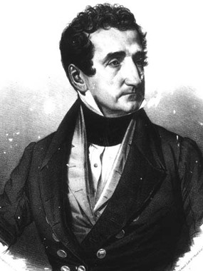
Joseph Marion Hernández (May 26, 1788 – June 8, 1857) He was the first Delegate from the Florida Territory and the first Hispanic American to serve in the United States Congress.
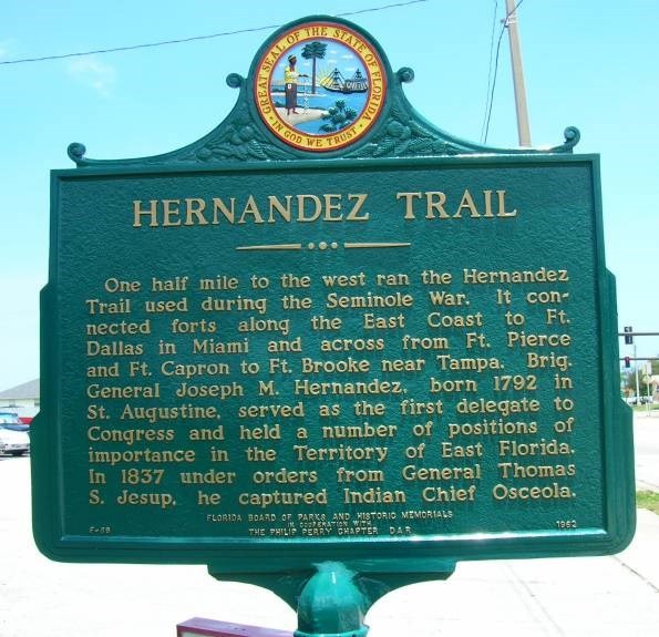
Marker Number: F-69 Date: 1962 County: Brevard Marker Type: Roadside
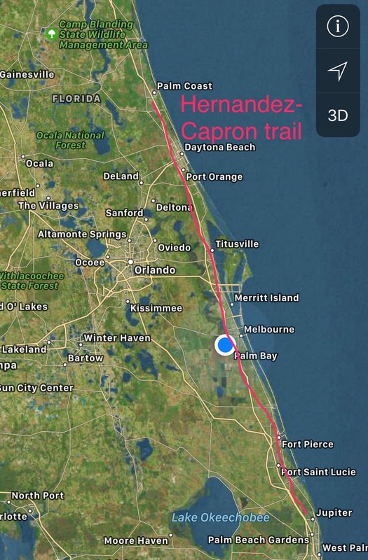
A concept of the Hernandez-Trail
Backstory and Context
Text-to-speech Audio
Joseph M. Hernandez (1792-1857), a life-long resident of the St. Augustine area, and a Brigadier General in the Army, was the first Hispanic Member of Congress and the first Territorial Delegate to represent Florida, bridged his state’s cultural and governmental transition from Spanish colony to U.S. territory. Hernández fought first for Spain and later for the United States; he also earned—and lost—a fortune that included three plantations and numerous slaves. General Hernandez was given an assignment around Dec., 1837. His job was he had to build a military road from St Augustine to Ft pierce. Without any construction roadbuilding equipment and a fierce enduring task, it was conducted during the Second Seminole War, and roadbuilding was so close to approaching the main area of Seminole territory, as he worked his way southward. Although it was built during the winter months, thus minimizing problems with hot, humid weather and malaria-carrying mosquitoes, construction of the road must have been quite a challenge for General Hernandez' men, especially with the ever-present concern with attacks from Indians and or wild animals.
Most of the road was constructed along the prehistoric dune line known to geologists as the Atlantic Coastal Ridge most of it all being high and dry terrain, and about a mile or so, west of present-day U.S.1. The first road from St. Augustine to the Ft. Pierce area was at least 16 feet wide, for mule wagons and ox carts, and over 200 miles long. It was road to connect forts, on behalf of the effort to remove the Seminole Indians, and eventually to support colonization of southern Florida.
The same road about a decade earlier, was partially cleared by Col. James Gadsden's troops, as far south as the St. Lucie River. Hernandez took it to Fort Capron, near that river. Gadsden and Hernandez both most likely followed the same trail used by the Seminoles for over a century, and by generations of native Ais and Timucuan Indians prior to that, as they traveled north and south, by horse or on foot, along the Rio de Ais now known as the Indian River. After 1838, the Hernandez Trail was rarely used for military use, in fact was used by many settlers as a main route for traveling. Traffic on the Hernandez Trail slowed down dramatically as new roads and new sources of travailing became more prevalent. Some portions of the trail are still visible on aerial photos, trail markers, throughout Brevard County and Indian River County.Sources
Brown, D. W., et. al. Water Resources of Brevard County, Florida. United States Geological Survey, Tallahassee, 1962.
Carter, Clarence E., ed. Territorial Papers of the United States, Vols. XXII-XXVI (Florida), Washington, D. C., 1956-1965.
Shoffner, Jerrell H. History of Brevard County, Vol. I, Brevard County Historical Commission, 1995.
Tebeau, Charlton W. A History of Florida, Univ. of Miami Press, 1971. 4/19/96