Statler's Fort Historical Marker
Introduction
Text-to-speech Audio
Images
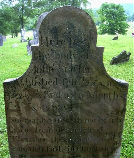
Left: John Statler Sr. grave marker. John Statler Sr, born in Germany May 4, 1733 died February 22, 1826 Statler has been credited for building Statler's Fort, which is located along Dunkard Creek in what is now the Clay District Of Monongalia
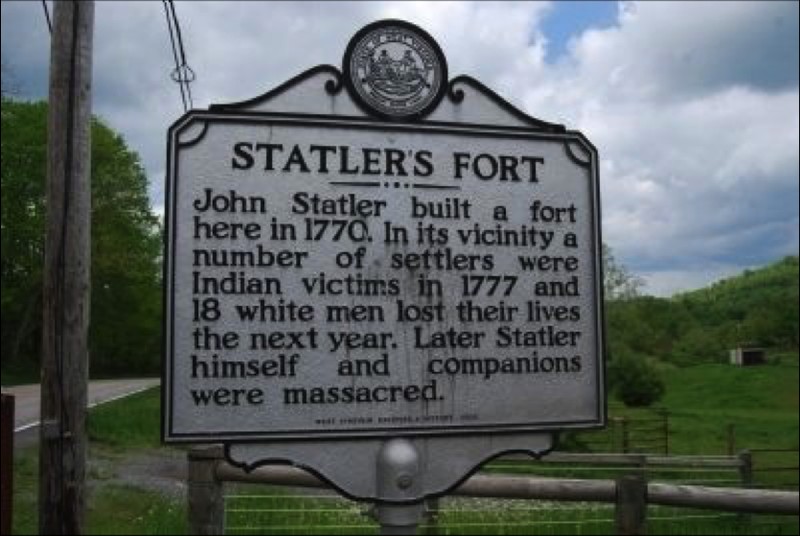
Statler's Fort Historical Marker near Blacksville, West Virginia, in Monongalia County. The marker is on Mason Dixon Highway / WV 7, 0.4 miles west of Mooresville Road. 39° 42.761′ N, 80° 8.261′ W
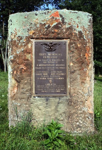
Revolutionary Soldier Memorial Marker. Statler is commemorated on this placard
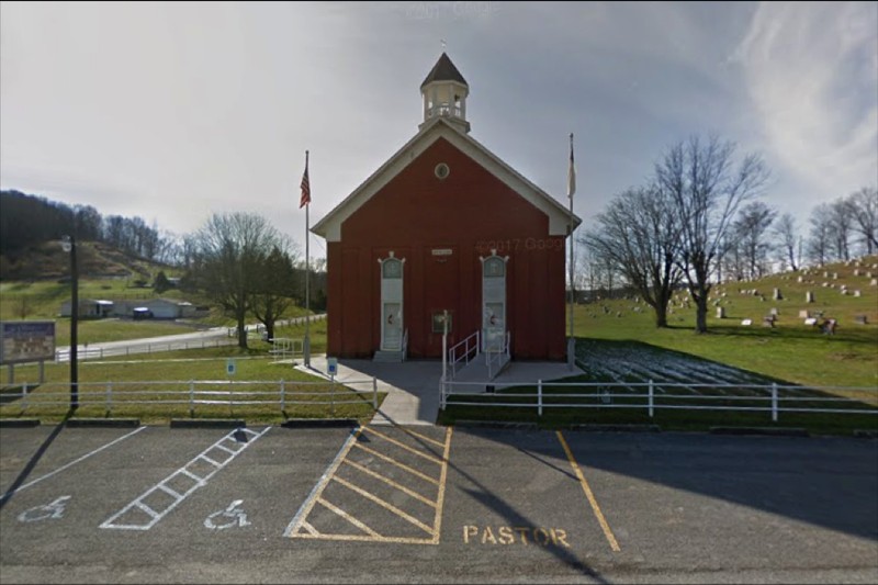
Olive United Methodist Church Location: 4367 Mason Dixon Hwy, Core, WV 26541 Phone: (304) 879-5992
Backstory and Context
Text-to-speech Audio
Statler's Fort was located in present-day today Core, West Virginia. If traveling from Star City, West Virginia, the marker is about seven miles east south-east located between Cassville, West Virginia 3 Miles and Pentress, West Virginia 3.5 Miles. The Fort said to have been built on George Statler’s farm not far from the Jones homestead. During the Native inhabitant raids of 1777-1779 area families lived at the Fort. The exact location of where the Fort once was is undetermined and the topic of much debate as indicated by resident, business owner and descendant by marriage Linda Statler.
Based on genealogical research of Pastor John Colby’s descendants, Jacob Straddler or Statelier was the brother of John Statler Sr. Jacob Statler is credited for erecting the Fort in 1774. He was a soldier in the Revolution who was then shot and killed in 1778 during a Native American attack.
Settlers wrote to the governor on numerous occasions asking for help from militias in Pennsylvania and Virginia without avail. They asked for 130 rifles and one thousand pounds of gunpowder. Colonel Thomas Gaddis, was appointed by Virginia Governor Patrick Henry, commanded troops at Fort Stradler (Statler) as well as several other forts.
The Daughters of the American Revolution, Elizabeth Ludington Hagans Chapter, Placed a cemetery tablet September 15, 1928 honoring the settlers killed by Native Americans in 1778. The marker was made possible by donations from A.C. Price and the William Price Family. The inscription on the tablet reads “This tablet is dedicated to the memory of 18 Revolutionary soldiers killed near here by the Indians in 1778, Jacob Statler, Joseph Wade, James Piles, John McDaniels, Michael Kederling. 13 other names unknown”.
Wyandot and Chippewa Tribes are believed to behind the ambush, although this information might be inaccurate. What is certain is that these men were attacked by Native Americans within two miles of the Fort The men had been in the area of Dolls Run about one mile from what is now Cassville. It has been documented on many accounts the men were harvesting corn and had slaughtered a hog. The men ambushed were scalped and mangled by the Natives.
Native Inhabitants attacks were common in what is now Core, West Virginia. The Native inhabitant raids of 1777, 1779 as well as random attacks made Statler Fort essential to settler survival. The closest aid or support was Baldwin Blockhouse nearly 7 miles away located in what is now Blacksville, West Virginia.
The original historical marker was located at 39.707450 Latitude and -80.148126 Longitude. This marker was moved due to auto accidents in this area and having to replace the marker on multiple occasions. The marker now resides at 39° 42.761′ N, 80° 8.261′ W However, due to recent elections involving a Statler the historical marker was stolen. It has been verified that a new marker will soon be placed at 39° 42.761′ N, 80° 8.261′ W
Sources
Session of Virginia Council of State, 10 November 1778. Founders online. November 10, 1778. Accessed September 20, 2017. https://founders.archives.gov/documents/Madison/01-01-02-0085. Session of Virginia Council of State, 10 November 1778 Session of Virginia Council of State MS (Virginia State Library). Tuesday November 10th 1778. present His Excellency; John Page David Jameson Dudley Digges James Madison Thomas Walker And Nathaniel Harrison Bolling Stark Esquires.
corbly, Don. Pastor John Corbly. Google Books. August 13, 2008. Accessed September 19, 2017. https://books.google.com/books?id=PeaRxwimacYC&pg=PA93&lpg=PA93&dq=john+statler++statler+fort&source=bl&ots=HHFkqSX1yI&sig=qd3v2UsR0WxuKcntcGJu6Y4_zv0&hl=en&sa=X&ved=0ahUKEwi4oe2mzrrWAhWJ5iYKHY_TCXA4ChDoAQgnMAA#v=onepage&q=john%20statler%20%20statler%20fort&f=false.
Toothman, Rick. Statler Family Historical Documents. "Early Statlers of Monongalia County, (West) Virginia". Accessed September 19, 2017. http://freepages.genealogy.rootsweb.ancestry.com/~statler/statler/docs/monongaliastatlers.html. This document may not be reprinted elsewhere without my permission. Rick Toothman, ©1992 ©2001 by David Statler of StatlerWeb Last Updated: February 29, 2008
Statler's Fort. THE HISTORICAL MARKER DATABASE. June 16, 2016. Accessed September 19, 2017. https://www.hmdb.org/marker.asp?marker=73801. This page was last revised on June 16, 2016. This page originally submitted on May 17, 2014, by Mike Wintermantel of Pittsburgh, Pennsylvania. This page has been viewed 389 times since then and 56 times this year. Photos: 1, 2. submitted on May 17, 2014, by Mike Wintermantel of Pittsburgh, Pennsylvania.
Statler's Fort. Historical Marker Project. October 17, 2014. Accessed September 19, 2017. http://www.historicalmarkerproject.com/markers/HM1EGS_statlers-fort_Maidsville-WV.html. HM Number HM1EGS Tags Forts and Castles, Native Americans Year Placed 2009 Placed By West Virginia Archives & History Marker Condition No reports yet
Statler Fort. Google Images. Accessed September 19, 2017. https://www.google.com/search?q=statler+fort&source=lnms&tbm=isch&sa=X&ved=0ahUKEwifrry3jLLWAhUBdSYKHdtBCsAQ_AUICigB&biw=1233&bih=630.
Harris, C. Leon. RECORDS OF COL. DANIEL McFARLAND, MONONGALIA COUNTY VA MILITIA, 1777 & 1778. Southern Campaign American Revolution Pension Statements & Rosters. January 20, 2013. http://www.revwarapps.org/b111.pdf. RECORDS OF COL. DANIEL McFARLAND, MONONGALIA COUNTY VA MILITIA, 1777 & 1778 Transcribed and annotated by C. Leon Harris. Revised 20 Jan 2013.
Harris, C. Leon. Pension Application of Thomas Gaddis S4292 VA PA. Southern Campaigns American Revolution Pension Statements and Rosters. Accessed September 20, 2017. http://revwarapps.org/s4292.pdf. Pension Application of Thomas Gaddis S4292 VA PA Transcribed and annotated by C. Leon Harris. Revised 20 Apr 2016.
Core, Earl L.. Chronicles of Core. Edition 3. Parsons, West Virginia. McClain Printing Company, 2002.
Nelson, William R. The Frontier War for American Independence. Mechanicsburg, Pennsylvania. Stockpole Books, 2004.