410 Brown's Alley
Introduction
Text-to-speech Audio
Images
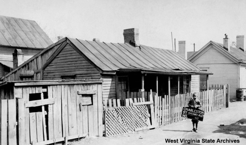
410 Brown’s Alley in the 1930s. Cramer Bollinger probably took the photo in 1936 when he was compiling pictures for a presentation on urban blight. The identity of the boy in the image is unknown.
This image was taken from a 1933 Sanborn Map of Charleston, West Virginia. The narrowest street, intersecting Bullitt, Young, and Court, is Brown’s Alley. 410 Brown’s Alley can be seen towards the left at the bottom of the map.

Backstory and Context
Text-to-speech Audio
During the Great Depression, a photographer stopped in front of 410 Brown’s Alley to take a picture (see first image). Cramer Bollinger had come to Brown’s Alley to capture scenes of urban blight for a presentation.1 In order to complete his vision, Bollinger asked a Black child to pose in front of the house. The young boy agreed to Bollinger’s request. As he stepped into place, Bollinger saw his story unfold. The frame house and its sinking foundation seemed to depict the poverty that white Americans associated with Black communities. 410 Brown’s Alley looked like a slum, a place for the impoverished—but it only represented half of the story. The surrounding area flourished as a hub of Black culture that residents would defend in the face of urban renewal.
Throughout the 1930s, and into the 1960s and 1970s, the Bureau of Negro Welfare and Statistics had observed housing difficulties in the Triangle District. They documented severe cases of overcrowding that had arisen because of a growing population and a corresponding lack of new housing.2 To make matters worse, homes were being built “too close together,” creating a high population density. The Bureau admitted that the ramshackle homes were seldom updated or maintained because the residents could only pay minimal rent, causing the landlords to be “reluctant about making repairs.”3 The Bureau attributed the poverty of most renters to their jobs. It concluded that 35% of African Americans in Charleston were domestic workers and that 30% of renters had no regular income.4 Ten years later, the Bureau reached similar conclusions: that current housing could not accommodate the population and that job discrimination was keeping many African Americans in poverty. Without explicitly saying “racism,” the Bureau acknowledged “[that] Negroes in Charleston occupy a place of racial subordination” due to “limited wage earning opportunities and concomitant low average income” as well as “undesirable housing.”5
The residents of 410 Brown’s Alley fulfilled the statistics that the Bureau described. They generally held menial, low-paying jobs, and they spent very little time in the house, probably because it was rented. Of the 11 known residents, four had jobs that could be identified in Charleston’s city directories. John Smith, a resident from 1917 to 1920, was a laborer.6 He shared the house with his wife, Martha, and his seven-year-old daughter, Rosa May.7 Mrs. Dora Walters, the next housing resident (1924), was a laundress.8 Annie Hardin replaced Mrs. Dora Walters and her companion, Henry German, in 1926. She was a domestic worker.9 The succeeding residents, Henry Lawson (1928), Lida E. Razor (1932), and Walter Colwell (1938), were not listed as workers.10 Freeman Manning, the 1934 occupant, was described as a driver in Charleston’s 1934 city directory.11 Asa Turner followed Manning in 1936 as a laborer, as well as Robert Wilson (1940) and Alf Carey (1942).12 After 1944, the house at 410 Brown’s Alley ceased to be occupied. It completely disappeared from city records in 1952.
410 Brown’s Alley was probably demolished between 1950 and 1952. The housing of African Americans in Charleston was long regarded to be “one of the most serious social problems facing the community.”13 The Bureau of Negro Welfare and Statistics specifically blamed houses like 410 Brown’s Alley for the crisis. “The charts alone will indicate over-crowding and bad housing,” it explained. “If we add to this fact that practically all dwellings now occupied by Negro families which were in existence prior to 1920 are of frame construction of the cottage type and very cheaply built… the results from a decent housing standard can better be imagined than described.”14 410 Brown’s Alley fit that exact description. It was built between 1908 and 1912, it had a frame structure, and it was cheaply constructed.15 Tearing it down was part of the urban renewal process. As late as 1965, Mayor Shanklin could be seen in the Triangle District, observing “vacant lots where once stood homes before demolition, and [watching] a few in the process of being razed.”16 410 Brown’s Alley had long since disappeared, but the street itself was shrinking.17 In 1926, 17 structures had a Brown’s Alley address. By 1974, only 407 Brown’s Alley remained.18
The disappearance of Brown’s Alley concluded a prolonged battle over urban renewal. Prior to 1974, a proposal for a water plant, a new interstate, and urban renewal had shaken the Triangle District. Residents learned that their houses would be demolished and their community destroyed.19 Fearing displacement, residents of the Triangle District organized protests in 1968, 1969, and 1970.20 For Black Charlestonians, the Triangle District represented safety, peace, and Black success. The whole District was not a slum or an “eyesore,” as one Charlestonian described it.21 It was a place of business and Black culture. Art galleries, grocers, and pharmacies lined the streets, while children attended school.22 Kojo Jones, an activist from Charleston, West Virginia, remembered the Triangle District fondly. Along “the Block,” where most of the businesses were located, Jones and his friends would gather at the Ferguson Theater. They would laugh, joke, and discuss who “was doin’ who, when for the most part nobody was doing much of anybody among my crew.”23 It was the same talk one could find amongst teenagers in white communities. For Jones, the Triangle District was an extension of his home, and he would lament its eventual destruction.
Former residents described a diverse community that protected African Americans from larger forms of discrimination. Chlorine Carter remembered “a beautiful area where everybody was your protector, and friends and family looked after one another.” Residents were proud to call the Triangle District their own because it was place of racial intermingling. Growing up on the Block meant playing with children of all races, Carter explained. “We lived in a mixed community, and we were friends with kids in the community.”24 Hubert “Rabbit” Jones had similar experiences. As a young man, he played improv jazz for interracial audiences both inside and outside of the Triangle District. When Jones played for white bars, guests would dance to the music, even though they were not supposed to dance to music performed by Black musicians. “Sometimes the policemen would stop them and sometimes they wouldn’t,” he mused. “And then following the dances some of the whites would come over to the Triangle District for the rest of the night, listening to and dancing to Black music.”25 The Triangle District was not a barrier against racism, but it dulled its dreadful impact, inviting people of every race to dance together.
Sources
1 Andre, Richard A., and Stan B. Cohen. Kanawha County Images, Volume II. Charleston, West Virginia: Pictorial Histories Publishing Co., Inc., 2001.
2-4 Bureau of Negro Welfare and
Statistics. “Negro Housing Survey of Charleston, Keystone, Kimball, Wheeling,
and Williamson.” 1938. Located in West Virginia and Regional History Center,
Morgantown, West Virginia.
5, 13 Kerns, J. Harvey. “A Summary
Report of the Survey of the Economic and Cultural Conditions of Charleston,
West Virginia, As They Relate to the Negro Population.” 1948. Located in
the West Virginia and Regional History Center, Morgantown, West Virginia.
6 1917 City Directory. Charleston, Kanawha, West Virginia. Page 535. John Smith, digital image, AncestryLibrary.com. Accessed April 3, 2018. https://search.ancestry.com/cgi-bin/sse.dll?_phsrc=oAb402&_phstart=successSource&usePUBJs=true&indiv=1&db=USDirectories&gss=angs-d&new=1&rank=1&msT=1&gsfn=john&gsfn_x=0&gsln=smith&gsln_x=NP_NN_NS&msrpn__ftp=Charleston,%20Kanawha,%20West%20Virginia,%20USA&msrpn=24704&mssng=martha&mssns=smith&_83004003-n_xcl=f&MSAV=1&uidh=6nm&pcat=37&fh=1&h=964698997&recoff=&ml_rpos=2.
7 1920 U.S. Census. Charleston, Kanawha, West Virginia. Page 3A. John Smith, digital image, AncestryLibrary.com. Accessed April 3, 2018. https://search.ancestry.com/cgi-bin/sse.dll?_phsrc=oAb410&_phstart=successSource&usePUBJs=true&indiv=1&db=1920usfedcen&gss=angs-d&new=1&rank=1&msT=1&gsfn=john&gsfn_x=0&gsln=smith&gsln_x=NP_NN_NS&msrpn__ftp=Charleston,%20Kanawha,%20West%20Virginia,%20USA&msrpn=24704&mssng=martha&mssns=smith&_F0B3C3B8=410&MSAV=1&uidh=6nm&pcat=35&fh=0&h=37359309&recoff=&ml_rpos=1.
8 1924 City Directory. Charleston, Kanawha, West Virginia. Page 677. Dora Walters, digital image, AncestryLibrary.com. Accessed April 3, 2018. https://search.ancestry.com/cgi-bin/sse.dll?_phsrc=oAb411&_phstart=successSource&usePUBJs=true&indiv=1&db=USDirectories&gss=angs-d&new=1&rank=1&msT=1&gsfn=dora&gsfn_x=0&gsln=walters&gsln_x=NP_NN_NS&msrpn__ftp=Charleston,%20Kanawha,%20West%20Virginia,%20USA&msrpn=24704&MSAV=1&uidh=6nm&pcat=37&fh=1&h=826880206&recoff=&ml_rpos=2.
9 1926 City Directory. Charleston, Kanawha, West Virginia. Page 343. Annie Hardin, digital image, AncestryLibrary.com. Accessed April 3, 2018. https://search.ancestry.com/cgi-bin/sse.dll?_phsrc=oAb413&_phstart=successSource&usePUBJs=true&indiv=1&db=USDirectories&gss=angs-d&new=1&rank=1&msT=1&gsfn=annie&gsfn_x=0&gsln=hardin&gsln_x=NP_NN_NS&msrpn__ftp=Charleston,%20Kanawha,%20West%20Virginia,%20USA&msrpn=24704&MSAV=1&uidh=6nm&pcat=37&fh=0&h=973992208&recoff=&ml_rpos=1.
10 1928 City Directory. Charleston, Kanawha, West Virginia. Page 392. Henry Lawson, digital image, AncestryLibrary.com. Accessed April 24, 2018. https://search.ancestry.com/cgi-bin/sse.dll?indiv=1&dbid=2469&h=868404334&tid=&pid=&usePUB=true&_phsrc=oAb626&_phstart=successSource. 1932 City Directory. Charleston, Kanawha, West Virginia. Page 468. Lida E. Razor, digital image, AncestryLibrary.com. Accessed April 24, 2018, https://search.ancestry.com/cgi-bin/sse.dll?_phsrc=oAb627&_phstart=successSource&usePUBJs=true&indiv=1&db=USDirectories&gss=angs-d&new=1&rank=1&msT=1&gsfn=lida&gsfn_x=0&gsln=razor&gsln_x=NP_NN_NS&msrpn__ftp=Charleston,%20Kanawha,%20West%20Virginia,%20USA&msrpn=24704&_83004003-n_xcl=m&MSAV=1&uidh=6nm&pcat=37&fh=1&h=872181401&recoff=&ml_rpos=2. 1938 City Directory. Charleston, Kanawha, West Virginia. Page 166. Walter Colwell, digital image, AncestryLibrary.com. Accessed April 24, 2018. https://search.ancestry.com/cgi-bin/sse.dll?_phsrc=oAb633&_phstart=successSource&usePUBJs=true&indiv=1&db=USDirectories&gss=angs-d&new=1&rank=1&msT=1&gsfn=walter&gsfn_x=0&gsln=colwell&gsln_x=NP_NN_NS&msrpn__ftp=Charleston,%20Kanawha,%20West%20Virginia,%20USA&msrpn=24704&msydy=1938&_83004003-n_xcl=f&MSAV=1&uidh=6nm&pcat=37&fh=0&h=944316226&recoff=&ml_rpos=1.
11 1934 City Directory. Charleston, Kanawha, West Virginia. Page 348. Manning Freeman, digital image, AncestryLibrary.com. Accessed April 3, 2018, https://search.ancestry.com/cgi-bin/sse.dll?_phsrc=oAb432&_phstart=successSource&usePUBJs=true&indiv=1&db=USDirectories&gss=angs-d&new=1&rank=1&msT=1&gsfn=freeman&gsfn_x=0&gsln=manning&gsln_x=NP_NN_NS&msrpn__ftp=Charleston,%20Kanawha,%20West%20Virginia,%20USA&msrpn=24704&mssng=roberta&mssns=freeman&msrdy=1934&MSAV=1&uidh=6nm&pcat=37&fh=0&h=833068484&recoff=&ml_rpos=1.
12 1936 City Directory. Charleston, Kanawha, West Virginia. Page 511. Asa Turner, digital image, AncestryLibrary.com. Accessed April 3, 2018. https://search.ancestry.com/cgi-bin/sse.dll?_phsrc=oAb416&_phstart=successSource&usePUBJs=true&indiv=1&db=USDirectories&gss=angs-d&new=1&rank=1&msT=1&gsfn=asa&gsfn_x=0&gsln=turner&gsln_x=NP_NN_NS&msrpn__ftp=Charleston,%20Kanawha,%20West%20Virginia,%20USA&msrpn=24704&MSAV=1&uidh=6nm&pcat=37&fh=6&h=828241469&recoff=&ml_rpos=7.1940 City Directory. Charleston, Kanawha, West Virginia. Page 815. Robert Wilson, digital image, AncestryLibrary.com. Accessed April 3, 2018. https://www.ancestry.com/interactive/2469/14303875?backurl=https%3a%2f%2fsearch.ancestry.com%2fsearch%2fdb.aspx%3fdbid%3d2469%26path%3d&ssrc=&backlabel=ReturnBrowsing#?imageId=14304290. 1942 City Directory. Charleston, Kanawha, West Virginia, Page 240. Alf Carey, digital image, AncestryLibrary.com. Accessed April 3, 2018, https://www.ancestry.com/interactive/2469/12665836?backurl=https%3a%2f%2fsearch.ancestry.com%2fsearch%2fdb.aspx%3fdbid%3d2469%26path%3d&ssrc=&backlabel=ReturnBrowsing#?imageId=14047363.
15 1907 Sanborn Map, Charleston, West Virginia. Located in West Virginia and Regional History Center, Morgantown, West Virginia. 1912 Sanborn Map, Charleston, West Virginia. Located in West Virginia and Regional History Center, Morgantown, West Virginia. 410 Brown’s Alley does not appear on the 1907 map, but it does appear on the 1912 map.
16 Unknown author. “Quick Remedy for Triangle Not in Sight.” The Charleston Daily Mail. Charleston, West Virginia September 28, 1965.
17 1926 City Directory. Charleston, Kanawha, West Virginia. Located in West Virginia and Regional History Center, Morgantown, West Virginia.
18 1974 City Directory. Charleston, Kanawha, West Virginia. Located in West Virginia and Regional History Center, Morgantown, West Virginia.
19 Thomas, Jerry Bruce. An Appalachian Reawakening: West Virginia and the Perils of the New Age Machine, 1945-1972. Morgantown: West Virginia University Press, 2010.
20 Connor, Charlie. “Mayor Reassures Triangle Negroes.” The Charleston Daily Mail. Charleston, West Virginia, August 7, 1968. Grimes, Richard. “Triangle Protest Rally Set Tonight.” The Charleston Daily Mail. Charleston, West Virginia, July 11, 1969. Unknown author. “Demolitions of Buildings in Charleston Protested.” The Weirton Daily Times. Weirton, West Virginia, July 9, 1970.
21 Connor, Charlie. “Mayor Says Bond Election Warning Clear: ‘Cut Fat.’” The Charleston Daily Mail, Charleston, West Virginia, October 26, 1967.
22 Randall, James D., and Anna Evans Gilmer. Black Past. Charleston: West Virginia Beacon Digest, 1989.
23 Jones, Kojo (William T.), Jr., and William M. Drennen, Jr. Red, White, Black, and Blue: A Dual Memoir of Race and Class in Appalachia. Athens: Ohio University Press, 2004.
24-25 Nuzum, Lydia. “Charleston Remembers ‘The Block,’ the Heart of Its Black Community.” Charleston Gazette-Mail, Charleston, West Virginia, May 25, 2014. Accessed April 10, 2018, https://www.wvgazettemail.com/news/charleston-remembers-the-block-the-heart-of-its-Black-community/article_d85fa49b-451c-5a17-8594-0ba35f31a1aa.html.
26 Todd, Roxy. “Despite Jim Crow Laws and Segregation, Charleston W. VA’s Nightclubs Were a Melting Pot.” WV Public Broadcasting. July 23, 2015. Accessed April 10, 2018, http://wvpublic.org/post/despite-jim-crow-laws-and-segregation-charleston-wvas-nightclubs-were-melting-pot#stream/0.