Barton Creek Greenbelt
Introduction
Text-to-speech Audio
Images
Map of Phase I of Violet Crown Trail, a 6 mile segment that opened in 2015.
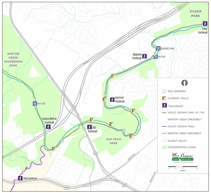
Image of Barton Creek from Barton Creek Trail.

Red Oak Tree

A pair of turtles in Barton Creek.

Sign of Barton Creek Greenbelt

Image of the Barton Creek Trail.

Backstory and Context
Text-to-speech Audio
Barton Creek runs through a bed of limestone, which is easily eroded by the flowing water. As a result, the creek has carved out canyons, valleys, and underground caves. The creek typically only flows above ground during the wet season and retreats underground during the dry season as part of the Edwards aquifer. The greenbelt is home to several endangered and rare species of wildlife. For example, the Barton Springs Salamander was discovered in the springs and exists only in the springs.
In 1828, William Barton moved to Texas as a member of Stephen F. Austin’s second colony. In 1837, he patented and settled on land near Barton Springs. The springs became a popular attraction and a symbol of Austin’s values of nature and community.1
In 1990, a company called Freeport-McMoRan wanted to develop the area along the creek into a residential area. Residents of Austin largely opposed the proposal for developing the area, worrying that construction and human activity along the creek would pollute Barton Springs5. Their concern was not unfounded, as many Austinites recalled that in 1981, the springs had been closed for 32 days after its waters were clouded by silt from the construction of the Barton Creek Square Mall.2
On June 7, 1990, a hearing was called in which Freeport-McMoRan, as well as the opponents of the development, presented arguments to a group of seven city council members. The hearing lasted until 5:19 AM, as all parties who wished to speak, were allowed to do so, the majority of whom spoke in objection to the development. The council’s decision was unanimous disapproval. This issue, which had received a large amount of local media coverage, stimulated a movement for the protection of the Barton Creek watershed.2
In the wake of the victory over the developers, an organization called the Trust for Public Land created the Greenbelt in order to protect the Barton Creek watershed.3 The organization ensures the safety of all wildlife and works hard to maintain the wonderful scenery.
Several different trails meander through Barton Creek. One of them is known as the Violet Crown Trail, which extends miles beyond its exit from the Barton Creek Greenbelt.4 The first section of this trail, most of which is located inside the greenbelt, was opened to the public in August 2015. This trail is a project by the Hill Country Conservancy, and when it is complete it will be 30 miles, the longest trail in Central Texas.5 Some of the trails in the Greenbelt are designated for mountain biking or hiking only, while others are intended for shared use.6 The Greenbelt contains a number of natural rock walls for climbing, swimming areas, and waterfalls.
Sources
6 Barton Creek Greenbelt. Save Barton Creek Association. Accessed November 26, 2018. http://www.savebartoncreek.org/barton-creek/barton-creek-greenbelt/.