Five Points (Bethesda)
Introduction
Text-to-speech Audio
Images
Five Points Historical Marker by Tom Fuchs on HMDB.org (reproduced under Fair Use)
Backstory and Context
Text-to-speech Audio
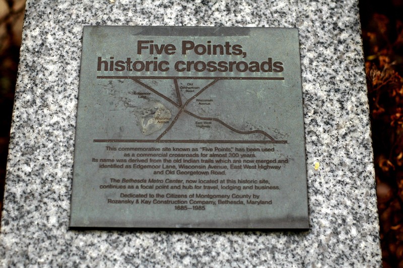
In 1985, local Bethesda construction company Rozansky & Kay placed a stone historic marker at this site to mark the historic crossroads known as the "Five Points." The marker is dedicated to the citizens of the Montgomery County. The stone plinth marker bears a plaque depicting a map of the intersection and commemorates three hundred years of travel along these routes, 1685-1985.
The trails used by Native Americans prior to the seventeenth century evolved over time to become major streets in Bethesda:
- Edgemoor Lane
- Wisconsin Avenue (Maryland Route 355), traveling north-south through the intersection
- East West Highway (Maryland Route 410) leading east from this location
- Old Georgetown Road (Maryland Route 187), leading northwest from this location
Maryland routes 187 and 410 originate at this spot. This intersection continues to be a hub of commerce and community in Bethesda. The Bethesda Metro Station, built in 1984 on the Washington Metro Area Transit Authority's Red Line, sits underneath this intersection and the exit emerges near this spot on Wisconsin Avenue. The establishment of the marker soon followed the opening of this metro station. As a result of this station's construction, one of the roads on the marker, Edgemoor Lane, no longer intersects with the other roads at this location; it now intersects with Old Georgetown Road northwest of the Five Points.
Sources
Fuchs, Tom. Five Points, historic crossroads, Historical Marker Database. September 21st 2019. Accessed February 17th 2020. https://www.hmdb.org/m.asp?m=84.
Washington Metro Area Transit Authority. Bethesda, Rider Guide: Stations. 2020. Accessed February 21st 2020. https://www.wmata.com/rider-guide/stations/bethesda.cfm.
Washington Metro Area Transit Authority. Metro Facts 2017 [archived web page]. 2017. Accessed February 21st 2020. https://web.archive.org/web/20180702201723/https://www.wmata.com/about/upload/Metro-Facts-2017-FINAL.pdf.
https://www.hmdb.org/PhotoFullSize.asp?PhotoID=164