Canal Landing/ Indiana's First Tax Free Mall
Introduction
Text-to-speech Audio
The Huntington Landing started 120 feet west on Washington St. and continued to the lock at Cherry St.
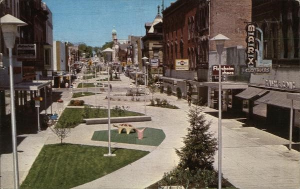
Jefferson Street was closed to motor traffic and transformed into a landscaped and lighted walkway by private financial contributors in 1969.
Images
Jefferson Park Mall c1970
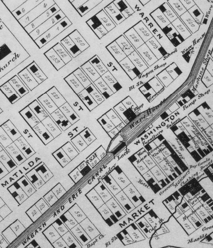
Wabash & Erie Canal Crossing Washington Near Jefferson
Backstory and Context
Text-to-speech Audio
The Wabash & Erie Canal was 4 feet deep and 100 feet wide at the Huntington Landing. Other locks were at First St. and Byron St. The Canal was completed from Fort Wayne to Huntington on July 4, 1835, and from Toledo to Evansville, 459 miles, in 1854. The Canal preceded the railroad to Huntington by 20 years, spurring early settlement. The Canal was abandoned in 1873.
The 1866 map of downtown Huntington shows where the Wabash and Erie canal crossed Jefferson Street just above Washington Street, about where Nick’s Kitchen is today (FYI they have really good pie). As you stand near the marker, make sure to look up and see the dates on tops of the buildings, especially those on the corner of Jefferson and Park, near the Rotary Centennial Park.
Jefferson Street was the Huntington segment of a pioneer route - the Fort Recovery to Goshen Road - travelled by settlers from Ohio to Lake Michigan and northwest areas in the 1830's. Jefferson Park Mall was a result of volunteer efforts in 1969 to create a non-drive through area for shopping and dining. There was a play area, benches and a fountain. The area was reopened to one-way traffic in 1991.
Sources
- IHB Marker Review. 35.1973.1 Canal Landing on Washington Street/ Jefferson Park Mall, 14 February 2013. https://secure.in.gov/history/files/35.1973.1_FINAL_FINAL.pdf. Accessed June 16, 2021.
- Heritage Days 2019 Buttons Now Available. Huntington County Chamber. http://huntingtoncountychamber.com/news/heritage-days-2019-buttons-now-available.html. Accessed June 18, 2021.
- “Canal Landing on Washington Street / Jefferson Park Mall,” IN.gov, accessed June 25, 2021, https://www.in.gov/history/state-historical-markers/find-a-marker/canal-landing-on-washington-street-jefferson-park-mall/
- Site Scapes. Huntington Parks and Recreation Department 2011-2015 Master Plan. https://www.huntington.in.us/egov/documents/1294155044_147827.pdf. Accessed June 17, 2021.
- Scheer, Luck, “Parking Lot Site Was Busy One in Canal Days,” Huntington Herald-Press [Huntington, Indiana], 6 December 1970.
- Map of Huntington Co., Indiana. 1866. Warner, Hayes & Warner. Ligonier, Ind.: E.B. Gerber & C.S. Warner.
https://www.cardcow.com/519425/jefferson-park-mall-huntington-indiana/
Map of Huntington Co., Indiana. 1866.