Paseo Delicias - Main Road
Introduction
Text-to-speech Audio
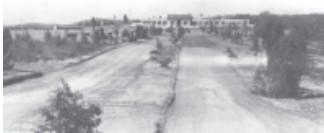
Paseo Delicias, circa 1923. Today the roads are paved and trees and plantings are abundant. The spirit of the place still remains.
Connecting to Del Dios Road and ending at The Inn, Paseo Delicias resides in the heart of the Civic Center, the first development of the Rancho Santa Fe planned community.
As the central road of development in the area, many of the Rice designed buildings were built around this road including, the Original Santa Fe Land Improvement Company Office, the Francisco Building, the Louise Badger Home, the First Rancho Santa Fe School, the Joers/Ketchum Store, the Row Houses, and the La Valencia Apartments. Because of its centrality, the Village expanded outward from this point and the area surrounding Paseo Delicias became a hub of activity as multiple stores and businesses took up space during Lilian Rice’s time and today.
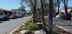
While the street is now paved and the storefronts have changed overtime, the historic charm of the place remains and at its heart is Paseo Delicas.
Images
Backstory and Context
Text-to-speech Audio
In 1906 the Santa Fe Railway, a subsidiary of the Atchison, Topeka & the Santa Fe, purchased all of the lands that made up the original San Dieguito land grant from several owners, including the Osunas. The railway’s intent was to use the land to grow lumber for railroad ties. From 1906 to 1914, after much study and experiment, Walter E. Hodges, vice president of Santa Fe’s California properties, planted 3.5 million Eucalyptus trees from seed on 3,000 acres in the southeast section of the land grant closest to the San Dieguito River. One of the main stretches of this land expiernement was located on what is now Paseo Delicias. However, the venture proved unsuccessful, predominantly because despite the species phenomenal rate of growth the trees had to be quite mature, even old growth, to have the structural capacity needed to underlay the rails for the great trains coming West.
Santa Fe was ready to walk away from their well-intended failure. Just weeks before they were to put the land grant on the market one of San Diego’s most significant land and water developers, Colonel Ed Fletcher, intervened and assured them they could change course and recoup their losses. Both Fletcher and the Santa Fe were fully aware of the agricultural potential of the property. In today’s horticultural parlance, San Diego County is known as the ‘Avocado Belt’, prime land for agriculture, horticulture, and most famously, floriculture. Fletcher convinced them that if they planted the land in citrus and avocados, they could make money off the ‘tonnage’, or shipping, of California fruit back East. The brilliant idea of ‘Gentlemen’s Farmer’ estates arose and from then on a new project was launched.
By 1921 Santa Fe filed a subdivision map generated by land expert and road engineer Leon Sinnard. It outlined land parcels that radiated out from a central core of small lots to very large ones. A Civic Center now referred as the ‘Village’ was comprised of the Santa Fe Land Improvement Company’s offices and Francisco’s food market, a Garage Block, a schoolhouse, village rowhouses for Santa Fe staff, and a Guest House, later named La Morada, now the Inn at Rancho Santa Fe. Later more commercial buildings were added. At the time of the filing of the map, Santa Fe decided to retire the name of Rancho San Dieguito for their namesake, Rancho Santa Fe.
Paseo Delicias has become the main road that leads from the heart of Rancho Santa Fe out to East County San Diego.
Sources
ca1694data.pdf (loc.gov)
64500059.pdf (nps.gov)
Joers-Ketchum Rowhouse, 6108 Paseo Delicias, Rancho Santa Fe, San Diego County, CA | Library of Congress (loc.gov)