National Road Mile Marker 11
Introduction
Text-to-speech Audio
Images
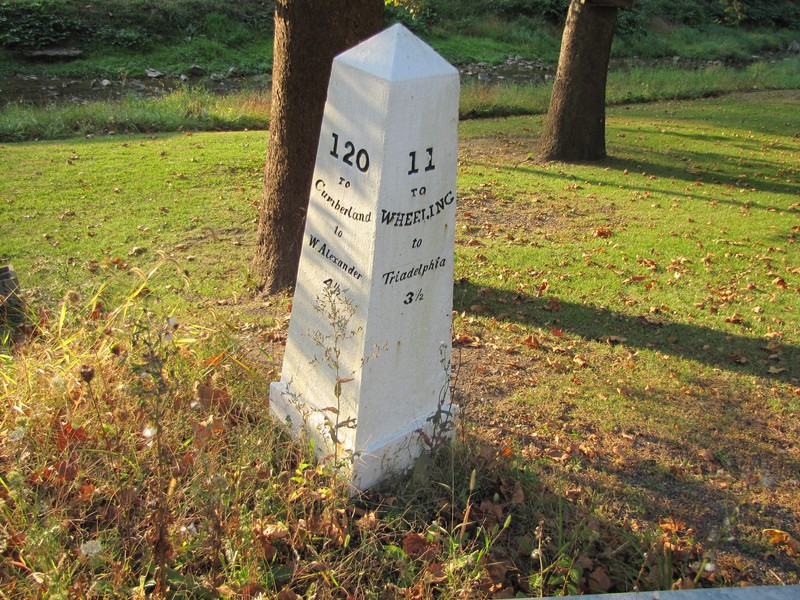
Photo of Mile Marker 11

Backstory and Context
Text-to-speech Audio
In the period after the Revolutionary War, Americans wanted to rapidly spread into the land west of the Appalachian Mountains. White exploration and settlement of that region had been occurring for some time, but access was usually through the network of trails and pathways used by Native Americans, limiting the opportunity for large-scale settlement and economic development. Shortly after the Revolution political leaders such as George Washington, Albert Gallatin, Thomas Jefferson, and Henry Clay advocated for the construction of new roads and canals to connect the states in the east to economic opportunities in the Ohio Valley and further to the Mississippi.
This expansion of transportation and economic opportunity for the new nation became a primary goal for Thomas Jefferson during his presidency. After the Louisiana Purchase in 1803, Congress authorized the construction of a roadway to connect the Potomac to the Ohio River in 1806. This first section of what would become the National Road was called the Cumberland Road, which connected Cumberland, MD and Wheeling, WV. Much of the route followed the earlier Braddock Road, opened in 1751 between Fort Cumberland and Fort Duquesne (Pittsburgh). The new road would follow the Braddock Road until around Uniontown, PA where it would turn west to Wheeling instead of continuing north to Pittsburgh.
Construction of the Cumberland Road was completed between 1811 and 1818, with the road reaching Wheeling in August of that year. Additional extensions connected the National Road east to Baltimore by 1824 and west to Illinois in the 1830s. Congress planned to extend the National Road all the way to Jefferson City, MO (they authorized this in 1820 and the extension into Illinois was part of this plan), but construction largely ended in 1839 and the road did not reach the Mississippi.
Heavy traffic quickly wore down the original road and in 1825 the U.S. Army Corps of Engineers took over management of the road and repaired and rebuild the roadway. After this the federal government passed management of the road to the individual states for upkeep (federal attention was moving towards new canal and railroad projects). Once the Baltimore & Ohio (B & O) Railroad extended to Wheeling in the 1850s, the National Road saw a period of decline as rail travel became more popular. In the 1900s when travel by car overtook rail travel, the National Road saw a new resurgence and it was incorporated into U.S. 40 which extends cross-country from Atlantic City to San Francisco. It remains a popular scenic route for travelers, although nearby Interstate 68 has largely replaced it as the main route for east-west travel.
Mile markers were placed every mile along the National Road to orient travelers. As mentioned in the description from the National Register of Historic Places Registration Form, the markers include the distance to Wheeling on the east side and the distance to Cumberland on the other side. These markers are cast iron, painted white with Black lettering and give the mileage to Cumberland and Wheeling. Markers in other states oriented travelers to different cities, such as Baltimore, Frostburg, or Washington. The markers in West Virginia were cast by the Snowden Foundry in Brownsville, PA and placed in the 1830s.
Sources
“National Register of Historic Places Registration Form: National Road Mile Markers Numbers 8, 9, 10, 11, 13, 14.” Accessed September 3, 2020. https://npgallery.nps.gov/NRHP/AssetDetail?assetID=2faedf7a-d64a-49a3-9f54-fa535d01712d.
“National Register of Historic Places Multiple Property Submissions Form: Historic and Architectural Resources along the National Road in Ohio County, West Virginia.” Accessed September 3, 2020. https://npgallery.nps.gov/NRHP/GetAsset/NRHP/64500729_text.
Peyton, Billy Joe. “National Road.” The West Virginia Encyclopedia. Accessed September 3, 2020. https://www.wvencyclopedia.org/articles/1591.
Raitz, Karl B., and George F. Thompson. The National Road. Baltimore: Johns Hopkins University Press, 1996.
Sky, Theodore. The National Road and the Difficult Path to Sustainable National Investment. Newark: University of Delaware Press, 2012.
"National Road Mile Markers Nos. 8, 9, 10, 11, 13, 14 - Triadelphia, West Virginia - U.S. National Register of Historic Places on Waymarking.com." Accessed September 7, 2020. https://www.waymarking.com/waymarks/WMKDG6_National_Road_Mile_Markers_Nos_8_9_10_11_13_14_Triadelphia_West_Virginia
Photo by Bwsmith84. "National Road." Wikipedia. Accessed September 7, 2020. https://en.wikipedia.org/wiki/National_Road#/media/File:National_Road_Mile_Markers_Numbers_8_9_10_11_13_14.jpg