Wabash & Erie Canal Lock 4
Introduction
Text-to-speech Audio
First lock west of summit level of Wabash and Erie Canal (connected Lake Erie with Ohio River in 1853). Known as Dickey Lock. Built as Lock 1, 1834-1835, of wood construction; renumbered Lock 4 as result of canal completion to Ohio line (1840). Remnant of arch culvert nearby. Canal important to founding of Roanoke.
Images
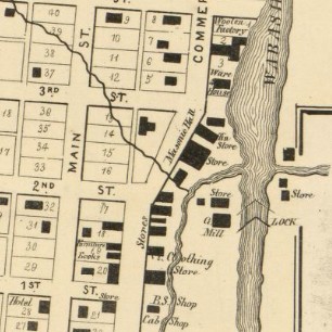
1866 Huntington County Map Detail Showing Lock Location
Backstory and Context
Text-to-speech Audio
The Wabash and Erie Canal was established as a means of transportation for both people and materials. The canal was difficult to construct and maintain due to flooding, mosquitoes and natural growth. Because of different water heights, locks were necessary in the construction of the canal. A lock allows water levels to rise or fall by opening or closing the ends of the chamber and raising or lowering water amounts in that area. In the days of the canal, “locking” would happen approximately one foot of water per minute, thus adding to travel time.
Dickey Lock (Lock #1, later renamed Lock #4) was the first lock to “step down” from the St Joseph River out of Fort Wayne. This lock was made of wooden timbers, but other locks were made from cut stone or composite (building stone that was of an inferior quality). The brothers Dickey (John, William and Robert) were very involved in canals in both Ohio and Indiana. In 1847, Dickey, Doyle & Dickey had a packet boat business on the Wabash & Erie Canal. These packet boats (also known as canal boats) had a set price for travel, a regular schedule, and were approximately thirteen feet wide by ninety-five feet long. It is likely that this early lock was named after one or all of the Dickey brothers.
The town of Roanoke was founded near the Dickey lock, with L.G Jones building first a saw mill and later a flour mill near the lock. The population of the town continue to increase from 1840 to 1849.
In 1855 the Lake Erie, Wabash and St. Louis Railroad completed its first segment from Huntington to Fort Wayne with regular service between the two cities beginning the next year and was complete to St. Louis before 1859. This route followed the Wabash and Little Rivers nearly paralleling the canal between Fort Wayne and Lafayette. Rail travel was faster and more cost efficient, causing the canal to be abandoned in 1873.
Sources
- “Wabash & Erie Canal Lock 4,” IN.gov, accessed June 24, 2021, https://www.in.gov/history/state-historical-markers/find-a-marker/wabash-and-erie-canal-lock-4/
- Castaldi, Thomas E, “Wabash & Erie Canal Notebook I”, Graphik Mechanux, 2002. (book available to view in the Keefer Room of the Huntington City-Township Public Library.
- Brennan, J. Fletcher, and Cleave, Egbert. “A Biographical Cyclop©Œdia and Portrait Gallery of Distinguished Men,” United States, J. C. Yorston, 1879.
- “Centennial Portrait and Biographical Record of the City of Dayton and of Montgomery County, Ohio: Containing Biographical Sketches of Prominent and Representative Citizens, Together with the Biographies and Portraits of the Presidents of the United States and Biographies of the Governors of Ohio,” United States, A.W. Bowen, 1897.
- “Biographies,” Ohio Genealogy Express, accessed June 25, 2021, http://www.ohiogenealogyexpress.com/montgomery/montgco_bios_1909/montg_bios_1909_d.htm
- “Historical Sketch of Huntington County, Indiana,” United States, Board of County Commissioners, 1877.
- Map of Huntington Co., Indiana. 1866. Warner, Hayes & Warner. Ligonier, Ind.: E.B. Gerber & C.S. Warner.
- Map of the Toledo, Wabash, and Gt. Western Rail Road Line, and its connections. Ca. 1859. Olmstead, S. R, and Wabash Toledo. https://www.loc.gov/resource/g3701p.rr005860 accessed 1 Jul 2021.
https://www.loc.gov/item/2013593187/