Zero Milestone
Introduction
Text-to-speech Audio
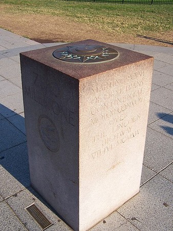
Created by sculptor Horace W. Peaslee, this marker was set in 1923 to replace an earlier stone placed in President's Park in 1919. The first marker signified the starting point of a U.S. Army motor convoy from Washington and San Francisco which explored and raised awareness about the needs of the nation's roads. The dedication of the official milestone took place on June 4, 1923. The stone is granite, four feet high with engravings on all sides and a compass rose on top. The original purpose of the stone was to set an origin point for measuring highways in the United States. Roads and distances within the nation's capital are still measured using the Zero Milestone.
Images
Zero Milestone by Charles Smith on Wikimedia Commons (CC BY-SA 3.0)
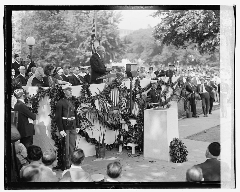
Unveiling of the Zero Milestone, 1923. National Photo Company, courtesy of Library of Congress and Wikimedia Commons (public domain)
Backstory and Context
Text-to-speech Audio
Capital planner Pierre L'Enfant had an idea similar to the zero milestone in 1791. The idea is based on the Golden Milestone in ancient Rome. Washington's version was the brainchild of Dr. S.M. Johnson, a supporter of the Better Roads Movement, which from the late nineteenth century sought to improve thoroughfares across the country.
In summer 1919, to raise awareness of issues with the nation's roads, a U.S. Army motor convoy of more than 60 vehicles planned to set out from Washington and drive to San Francisco. To mark the starting point, and to establish an origin point for all the nation's roads, a temporary marker was placed at this spot. Congress authorized the official milestone on June 5, 1920. The dedication ceremony took place almost exactly three years later, on June 4, 1923. The U.S. Army band played a song specific to the occasion, and Dr. Johnson and President Warren G. Harding spoke.
The north face of the milestone pillar, which faces the White House, simply reads "Zero Milestone" with an engraving of the winged helmet of classical messenger god Mercury. The east face reads, "Starting point, second trans-continental motor convoy over the Bankhead Highway. XIV Jun MCMXX [June 14, 1920]." The south side, which faces the Ellipse, reads "Point for the measurement of distances from Washington on highways of of the United States." The west face gives similar information to the east face: "Starting point of first trans-continental motor convoy over the Lincoln Highway. VII JVL MCMXIX [July 7, 1919]."
Sculptor and landscape architect Horace Peaselee carved the pillar from Milford granite, with a bronze plaque on the top resembling a mariner's compass. Peaslee had served as part of the United States Office of Public Buildings and Grounds, and was the primary architect for Meridian Hill Park, before designing the milestone. In the early 1920s, he helped to found and was involved with the Committee of 100 on the Federal City, a citizens' group on urban planning and design.
As stated by a plaque in the sidewalk beneath the pillar, the latitude, longitude, and elevation of the milestone were determined by the U.S. Coast and Geodetic Survey.
Another milestone in the capital's history was the Washington Meridian, placed in 1804. The original stone was an obelisk that marked the northern boundary of 16th Street NW, at Meridian Hill, about two miles north of where the current milestone stands. This older stone was directly north of the White House, on the "White House Meridian" establishing east-west longitudinal divide for American cartographers until 1884. The northward extension of this street in the early 1900s destroyed the stone. At one time, a plaque marked the approximate location of the original stone. This plaque, near the milestone donated by the Army and Navy Chapter of the Daughters of the American Revolution notes that the original stone stood 52 feet and nine inches west of the plaque.
Sources
Miller, Richard E. Washington Meridian - "The Stone", Historical Marker Database. August 10th 2020. Accessed December 6th 2020. https://www.hmdb.org/m.asp?m=82518.
Miller, Richard E. Zero Milestone Historical Marker, Historical Marker Database. August 10th 2020. Accessed December 6th 2020. https://www.hmdb.org/m.asp?m=32486.
National Park Service. Horace Peaslee, Rock Creek Park: People. January 16th 2016. Accessed December 6th 2020. https://www.nps.gov/rocr/learn/historyculture/hpeaslee.htm.
Veroske, Ariel. "All Roads Lead to Washington: The Zero Milestone," Boundary Stones: WETA's Local History Blog. July 10th 2013. Accessed December 6th 2020. https://boundarystones.weta.org/2013/07/10/all-roads-lead-washington-zero-milestone.
"Zero Milestone," Histories of the National Mall, accessed December 4, 2020, http://mallhistory.org/items/show/5.
https://commons.wikimedia.org/wiki/File:Zero_Milestone_100_5015_(4942809865).jpg
https://commons.wikimedia.org/wiki/File:Unveiling_zero_milestone_LOC_npcc.08758.jpg