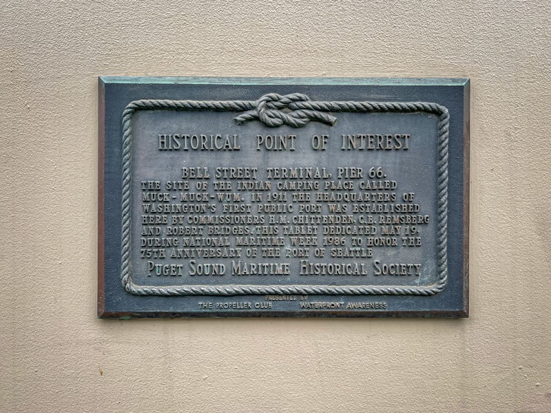
Bell Street Pier Historical Marker (Pier 66)
Introduction
Text-to-speech Audio
This marker commemorates the history of Seattle's Bell Street Pier, while acknowledging the earlier presence of the Coast Salish native people who lived and fished in this area for millennia. Later renamed Pier 66, the Bell Street Pier opened in 1915 with a bay-front dock for large ocean-going vessels, as well as a wooden shed-style cold-storage warehouse for loading and unloading cargo. The Bell Street Pier also became the headquarters for the Port of Seattle, which was established in 1911, owning and operating the first public seaport in Washington State. A historical marker was placed at the site during National Maritime Week in May 1986 in honor of the 75th anniversary of the Port of Seattle. The marker was dedicated by the Puget Sound Maritime Historical Association and the National Propeller Club.
Images
Bell Street Pier Historical Marker
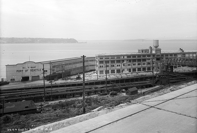
Bell Street Pier, 1915
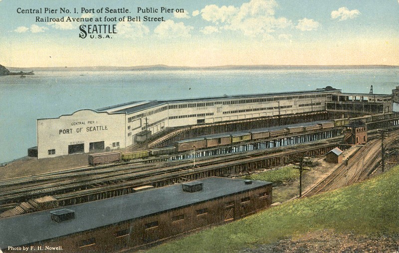
Historic Bell Street Pier
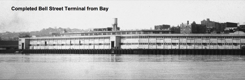
Bell Street Terminal as seen from Elliott Bay
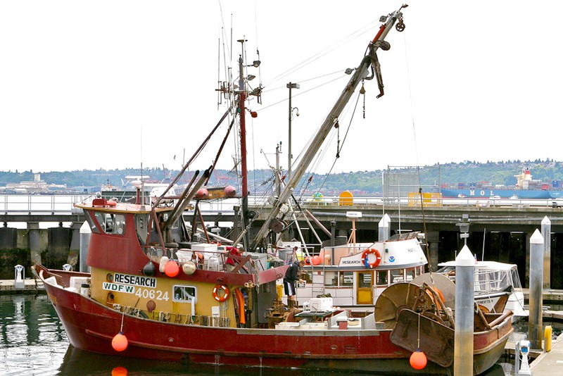
Washington Dept. of Fish & Wildlife research vessel at Bell Street Pier, 2007
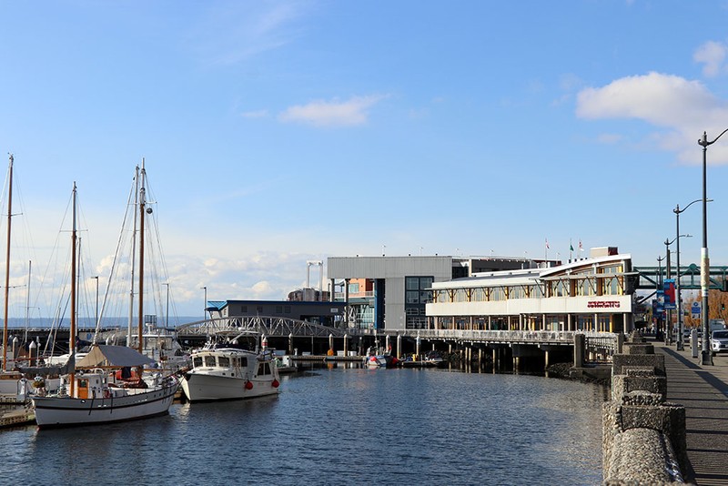
Bell Street Pier and Anthony's Restaurant, 2020
Backstory and Context
Text-to-speech Audio
From 1914 to 1915, Bell Street Pier was constructed atop fill that was dumped along the waterfront at this location. The fill was the result of the Denny Regrade, a large-scale engineering project that created a uniform elevation by leveling the hills in Seattle's Denny Hill neighborhood. Once the Bell Street Pier was completed, the Port of Seattle maintained a headquarters building here. The site was ideal as it was proximate to the city's business district, and it connected to the Belltown neighborhood via a wooden trestle bridge traversing Railroad Avenue (later named Alaskan Way). Initially, the Bell Street Pier contained a wooden shed-style cold-storage warehouse erected on pilings, while its bay side provided dock space for large ocean-going vessels.
According to the historian, Paul Dorpat, in his book, Seattle Waterfront: An Illustrated History, originally ramps led up from Railroad Avenue to the Port of Seattle headquarters' second story entrance on the Bell Street Pier. On top the building were potted plants, benches, a solarium, and a play area where children would be supervised while their parents shopped at the nearby Pike Place Market. By 1920, however, this second-floor area was closed off to the public, as it was frequently used at night as a meeting spot for sailors and their dates. The city decided that keeping the area open was a "moral nuisance," in part due to concerns over pregnancies, along with a strong current of moralism at the start of Prohibition in 1920. At the same time, sailors often found themselves struggling to reintegrate after returning home after World War I.
As freight shipping became increasingly important to the continued economic development of the city, the Port of Seattle proved to be well-equipped to handle massive transfers of cargo along the waterfront. In the early 20th century, Seattle already had one of the most advanced industrial waterfronts of any city on the West Coast. Cargo could be unloaded exceptionally quickly, averaging only a quarter of the time that it took San Francisco to complete a job of comparable size. The Port of Seattle also held the further distinction of being the only municipal corporation to own as well as operate its numerous wharves and piers. It also benefitted from the fact that its Bell Street Pier headquarters building was close to the city's central business district.
Renamed Pier 66 during World War II, the Bell Street Pier continued to serve as one of the city's primary wharves in the post-war years. By the mid-1990s, Pier 66 was reconstructed, along with the adjacent piers, to create "The Bell Street Pier and Bell Harbor Complex," which included a cruise ship terminal, a marina, a conference center, shops, restaurants, and the Odyssey Maritime Discovery Center. Today, this terminal complex comprises eleven acres along Seattle's downtown waterfront. Companies such as Oceania Cruises and Norwegian Cruise Lines dock their vessels here, while providing seasonal passage to and from Alaska. The Bell Street Pier Complex is a short walk to Pike Place Market and to Miner's Landing, the Great Wheel, and the Seattle Aquarium at Piers 57 and 58.
Sources
"Bell Street Cruise Terminal (Pier 66)", Port of Seattle. Accessed August 14th, 2023. https://www.portseattle.org/places/bell-street-cruise-terminal-pier-66.
Donnelly, Devlin. "Hidden in Plain Sight: Gems at Bell Street Pier", Port of Seattle. August 24th, 2022. Accessed August 14th, 2023. https://www.portseattle.org/blog/hidden-plain-sight-gems-bell-street-pier.
Dorpat, Paul. "Seattle Central Waterfront, Part 9: Bell Street Pier and Vicinity", HistoryLink. May 24th, 2000. Accessed August 14th, 2023. https://www.historylink.org/file/2479.
Dorpat, Paul. Seattle Waterfront: An Illustrated History. Seattle, WA. HistoryLink Publications, 2005.
Dorpat, Paul . "Seattle Waterfront History, Chapter 5", Paul Dorpat. May 16th, 2009. Accessed August 14th, 2023. https://pauldorpat.com/2009/06/16/seattle-waterfront-history-chapter-5/.
Puget Sound Historical Society. Maritime Seattle. Images of America. Charleston, SC. Arcadia Publishing, 2002.
Swackhamer, Barry. "Bell Street Terminal, Pier 66", Historical Marker Database. October 9th, 2011. Accessed August 14th, 2023. https://www.hmdb.org/m.asp?m=48002.
Port of Seattle
Seattle Municipal Archives
HistoryLink
Paul Dorpat, Seattle Waterfront: An Illustrated History
HistoryLink / Photo by Gracjan Rotke (CC BY 3.0)
HistoryLink / Photo by David Koch