Buckeye (Ghost Town)
Introduction
Text-to-speech Audio
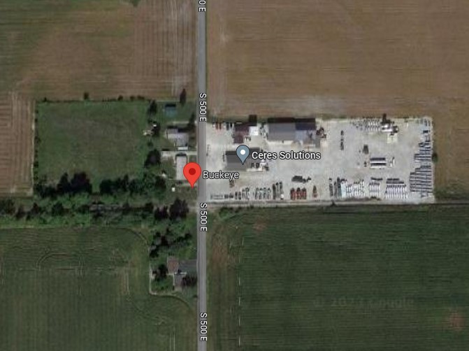
Buckeye was a small town that popped up in Salamonie Township once a railroad was run through the area. The land was originally plotted by Samuel Swaim in 1875 on a commission by Samuel T Jones and Loren B Minn, but was not officially recorded until 1879. It was in this small Huntington County Town that a world record was once set in 1887 for the most miles of rail laid in one day. Currently, all that remains of the town is three homes and a branch of Ceres Solutions, an agricultural cooperative company.
Images
Modern Aerial View
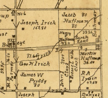
Buckeye in 1903
Backstory and Context
Text-to-speech Audio
In 1879, the Delphos, Bluffton, and Frankfort Narrow Gauge Railroad was built and ran through an area of Huntington County 3 ½ miles east of the city of Warren. This area became a railroad station and town called Buckeye. The plats for the land were filed with the County Recorder’s office on October 2, 1879 and people began to settle there. John Foust was encouraged to move his general store from Salem, 1 ½ miles to the south, up to the new town of Buckeye. The store was set up on the north side of the railroad tracks for easy access to both townspeople and travelers passing through. The general store passed hands through the generations but in some capacity or another, it existed in Buckeye until about 1932. In 1933, a new general store was opened by Carl Hunnicutt who operated the store with his wife Mary until they sold it in 1953 to Buford and Kate Ruse. Mr. and Mrs. Ruse operated the general store until it burned down in 1957.
The railroad run through town in 1879 was a narrow gauge of about three feet instead of the standard gauge of around four feet. As the railroads grew and merged, railroad officials began to favor Buckeye as a railroad station over other railroad towns in the area, such as its neighbor to the east, Boehmer. Eventually, a decision was made to widen the tracks to the standard gauge to make them more efficient. On Sunday June 26, 1887, at a pay rate of $2.50 a day, a total crew of around 2,000 men widened the rails as citizens of Buckeye gathered around to watch. At the end of the day, the men had moved an entirety of about 206 miles of track, setting a world record for most miles of rail laid in one day. Those tracks still exist today as a part of a small spur railroad called the Wabash Central.
Another feature of Buckeye was its post office. John Foust was named the postmaster on April 8, 1879 and ran the post office out of his general store. In 1895, Simon Foust took over the position on the 15 of August. The post office continued to operate in the town until it was discontinued in June of 1920, making it the longest lasting post office in Salamonie Township. Afterwards, all the town’s mail was sent to Warren.
Buckeye could be spotted on maps as early as 1895, when it first appeared on the Huntington County map. It can still be found on maps to this day even though all that is left in the area is a few houses and a couple businesses. The area where the town used to exist can be easily found as it is marked on Google Maps.
Sources
- Ancestry.com. U.S., Appointments of U. S. Postmasters, 1832-1971 [database on-line]. Provo, UT, USA: Ancestry.com, 2010. Original data: Record of Appointment of Postmasters, 1832-1971. NARA Microfilm Publication, M841, 145 rolls. Records of the Post Office Department, Record Group Number 28. Washington, D.C.: National Archives
- History of Huntington County, Indiana: A Narrative Account. 1914. Frank Sumner Bash. Chicago: Lewis Pub. Co., p154
- Map of Huntington Co., Indiana. 1895. H. H. Wagoner, Huntington, Ind. (poor photocopy)
- Huntington County, Indiana. 1903. Herman Taylor, Warsaw, Ind.: National Map Co. Rockford, Ill.: Hixson Map & Litho. Co.
- “Buckeye History”. Carl L Hunnicutt.
- https://www.ceres.coop/about accessed 5 Aug 2013
- State of Indiana 2021 Rail System Map. Available on https://www.in.gov/indot/multimodal/railroad/maps, accessed 5 Aug 2023.
Google Maps
1903 Huntington County Map