Boehmer (Ghost Town)
Introduction
Text-to-speech Audio
The little hamlet of Boehmer is one of two established along the former Nickel Plate Railroad. It had a post office from March 1879 until Oct 1891. Only a church is left from that time.
According to local tradition, the town was named after Joseph Boehmer, a one-time mayor of Delphos and one of the founding members of the railroad.
Images
Boehmer in 1903 (Unlabelled)
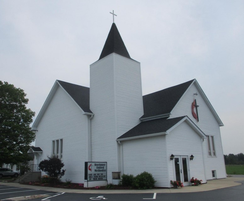
Boehmer United Methodist Church
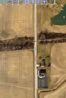
Modern Aerial Showing Boehmer's Plat.
Backstory and Context
Text-to-speech Audio
Boehmer and Buckeye were both established along what was then the Delphos, Bluffton, and Frankfort narrow gauge railway. (Later, the rail line became the Cloverleaf, then the Nickel Plate R.R., a nickname for the New York, Chicago and St. Louis Railroad. Later it became part of the Norfolk & Western Railroad. Now it is a small spur railroad – the Wabash Central.)
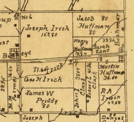
Boehmer was on the county line at about what is now 945 S., and Buckeye was only a mile away at 950S. Boehmer received its post office one month before Buckeye, but Buckeye's lasted until 1920. Boehmer is only labelled on the 1895 and 1903 county maps. It was platted in 1879 by Jacob Zent and had 14 lots, only four of which were north of the railroad. It had two streets: Front street (now 1000 W or 600 E, Huntington or Wells Co designations respectively), and Back street, one block west and parallel to Front Street.
The Boehmer Methodist Protestant Class was organized in March 1886. In June 1887 they obtained a deed to the property a few hundred feet south of the railroad on the Wells County side of the street. The building was complete by the summer of 1888. Around 1908, the belfry was struck by lightning. When repairs were made, stained glass windows were also installed.
Although it never had its own school, at its peak it had a general store/rail depot/post office, a blacksmith, an elevator and scale yard for grain. In 1904, the Marion, Bluffton, and Eastern Interurban built a depot about ½ mile north and called it Boehmer. By 1927 the more favorable location of Buckeye (from a railroad company standpoint) caused Boehmer's demise.
Besides the church and its pastoral residence, there is only one residence left in this little town, and the latter was built about 2003. However, the plat of the village is still visible on the official land software of Beacon, GIS. Even the Eiler family cemetery somewhere south of the village has disappeared. It never did appear on any maps. It was possibly located along W 400 S (the Wells County side of the intersection south of the church) where several Eiler families had property.
Sources
- Ghost Towns of Huntington County. 1971. Doris Chambers, p82-89
- History of Huntington County, Indiana: A Narrative Account. 1914. Frank Sumner Bash. Chicago: Lewis Pub. Co., p154
- https://www.nkphts.org – History of the Clover Leaf and Nickel Plate Railroads. Accessed 7 Aug 2023.
- 'Toledo, Cincinnati and St. Louis Railroad.' in Poor's Manual of Railroads. United States: H.V. & H.W. Poor, 1884. Vol. 17, p585 https://www.google.com/books/edition/Poor_s_Manual_of_Railroads/urcvAQAAMAAJ accessed 2 Aug 2023.
- 'Boehmer UM to celebrate 125th year with ice cream social and 5K run/walk.' 25 Jun 2012. Huntington County Tab. http://www.huntingtoncountytab.com/community/17144/boehmer-um-celebrate-125th-year-ice-cream-social-and-5k-runwalk
- Boehmer History file in the Huntington City-Township Public Library, hctpl.info.
- Ancestry.com. U.S., Appointments of U. S. Postmasters, 1832-1971 [database on-line]. Provo, UT, USA: Ancestry.com, 2010. Original data: Record of Appointment of Postmasters, 1832-1971. NARA Microfilm Publication, M841, 145 rolls. Records of the Post Office Department, Record Group Number 28. Washington, D.C.: National Archives
- Beacon GIS Wells Co property report for Boehmer United Methodist Church. Accessed 9 Aug 2023 https://beacon.schneidercorp.com/Application.aspx?AppID=173&LayerID=2165&PageTypeID=4&PageID=1121&KeyValue=90-09-19-200-001.000-013
- Beacon GIS for Huntington County. Intersection of 600E and railroad (1/2 mile south of 900S). https://beacon.schneidercorp.com/ Accessed 9 Aug 2023.
- Map of Huntington Co., Indiana. 1895. H. H. Wagoner, Huntington, Ind. (poor photocopy)
- State of Indiana 2021 Rail System Map. Available on https://www.in.gov/indot/multimodal/railroad/maps, accessed 5 Aug 2023.
1903 Huntington County Map
Beacon GIS for Wells County
Beacon GIS for Huntington County