Seligman, Birthplace of Historic Route 66 Sign
Introduction
Text-to-speech Audio
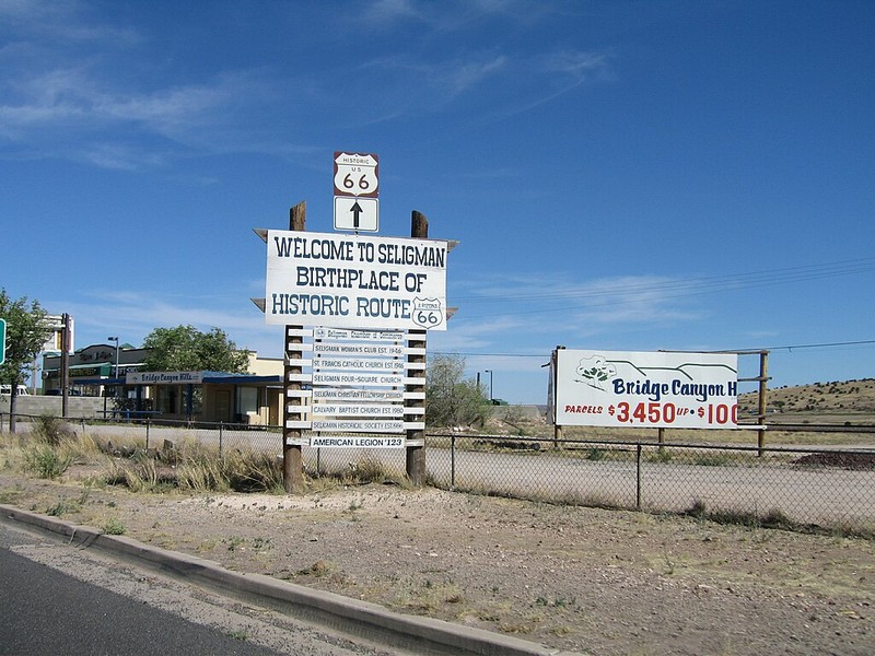
Signs proclaiming Seligman as the birthplace of historic Route 66 greet visitors on both the east and west sides fo the quintessential historic Arizona town. Claims about the road's birthplace can be found from Illinois to California, but this proclamation about Seligman is unique. Rather than claiming a piece of the Mother Road's 1920s origin story, Seligman's claim to Route 66 fame is related to a 1987 effort to restore the name of the historic route to what is now the longest still-operating stretch of the historic road. In that year, a group led by local barber Angel Delgadillo established the Historic Route 66 Association, which convinced the state government to designate Route 66 as a historic highway. For his efforts, Delgadillo earned the nickname "guardian angel of Route 66." Seligman also became known as the "birthplace of historic Route 66" as it is the starting place of the longest stretch of road named in honor of Route 66.
Images
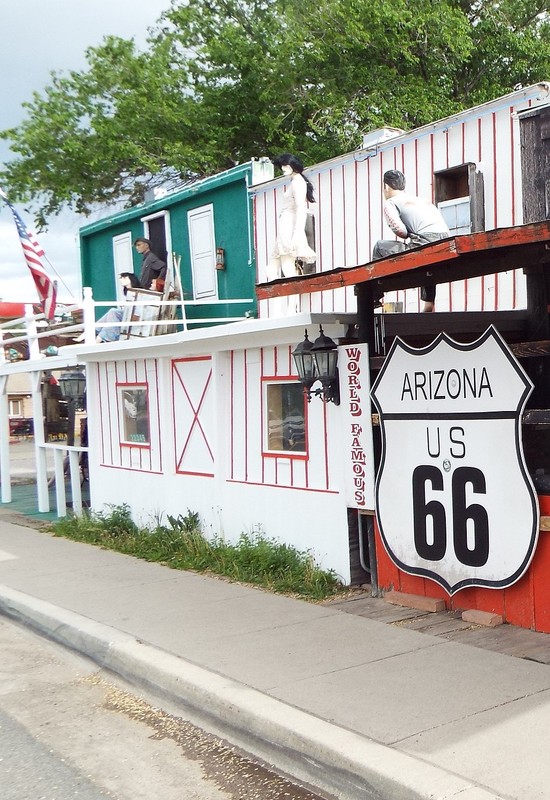
Signs proclaim Seligman as the birthplace of historic Route 66
The Seligman Sundries store is one of several businesses that cater to tourists in Seligman.

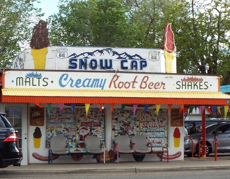
The Snow Cap Drive-In is a popular stop in town.
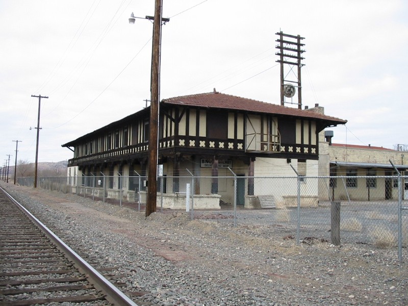
The Havasu Harvey House provided quality lodging and food to tourists for several decades. It was demolished in 2008.
Backstory and Context
Text-to-speech Audio
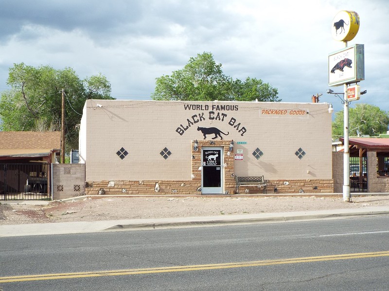
The old Route 66 highway, the legendary thoroughfare that once stretched from Chicago, Illinois, to Santa Monica, California. It features several historic buildings dating to the early 20th century that are associated with railroading and tourism such as gas stations, auto repair shops, gift shops, restaurants, commercial buildings, and motels. Some of these buildings are still open today and cater to travelers, both Americans and foreigners, seeking an authentic Route 66 experience. Famous attractions include the Snow Cap Drive-In restaurant and the Black Cat Bar. Several of these buildings are contributing properties of the Seligman Commercial Historic District, which is listed on the National Register of Historic Places.
Settlers began arriving in the area in the 1880s after the Atchison, Topeka & Santa Fe Railroad (ATSF) reached what is now Seligman in 1882 (the ATSF was first known as the Atlantic & Pacific Railroad). The town was initially named Prescott Junction because it was where the Santa Fe line intersected with another line that ran south to the territorial capitol of Prescott. In 1886, when the town was founded, Prescott was renamed Seligman in honor of New York banker Jesse Seligman, who supported the ATSF financially. Seligman was also an important division and shipping point for the railroad. Its location on flat terrain made it an ideal place for a switching yard and where goods and livestock from nearby ranchers could be shipped. A stockyard was built east of the railroad complex where tens of thousands of livestock (horses, sheep, and cattle) were processed for shipment. Workers (and their families) settled in Seligman and found work as mechanics, yardmen, machinists, storehouse keepers, clerks, and others.
One important moment in Seligman's history was the construction of a hotel and restaurant called Harvey House in 1905. It was built by the Fred Harvey Company, which its namesake founded in 1876 and operated a chain of hotels and restaurants in the West (it also operated dining cars). The company was very successful, earning a reputation for good food at reasonable prices. The ATSF contracted with the company and soon Harvey House hotels were built along the Santa Fe route. In Seligman, the Harvey House was called "Havasu House," a reference to the local Havasupai tribe. It was torn down in 2008.
In the early 1900s, usage of personal automobiles rose steadily and people began arriving Seligman by car instead of rail. This resulted in the need for improved roads and automobile infrastructure in Seligman and around the country. In 1912, the National Old Trails Road was created that linked various roads and trails into one highway that began in Baltimore and ended in Los Angeles. It passed through Seligman and numerous other towns and communities. The streets in Seligman were enlarged and streetlights and sidewalks were built. Existing businesses expanded new ones were established including gas stations, car dealerships, and restaurants. This growth was in response the increasing demands of travelers on the Old Trail. In 1926, the road was designated as Route 66, which soon became known as the "Main Street of America" because it connected so many communities together.
Seligman peaked after World War II. Millions of people migrated West to California and many of them traveled on Route 66. Americans also started to travel around the country in large numbers and the Southwest became a popular region. Guidebooks noted Seligman's businesses offering services to travelers. Since competition was high among communities along Route 66, businesses created catchy slogans, used neon signs and other novel ways to attract customers.
In 1966, Route 66 was widened in Seligman to relieve traffic congestion. However, ten years earlier, the federal government enacted the Interstate Highway Bill, which authorized the construction of a network of major highways. Many towns were bypassed in the years that followed, including Seligman in 1978. Virtually overnight, traffic in Seligman dropped significantly. As a result, businesses were closed and boarded up. In 1984, the ATSF ended its operations in Seligman.
In 1987, a group led by local barber Angel Delgadillo established the Historic Route 66 Association, which convinced the state government to designate Route 66 as a historic highway. For his efforts, Delgadillo earned the nickname "guardian angel of Route 66." Seligman also became known as the "birthplace of historic Route 66." While not the bustling community it was during its heyday, Seligman lives on as a destination for tourists.
Sources
"Seligman." TheRoute-66.com. Accessed September 16, 2023. https://www.theroute-66.com/seligman.html.
Stein, Pat H. "Seligman Commercial Historic District." National Park Service - National Register of Historic Places Nomination Form. February 1, 2005. https://npgallery.nps.gov/AssetDetail/NRIS/04000511.
Wikipedia
All images via Wikimedia Commons: https://commons.wikimedia.org/wiki/Category:Seligman_Commercial_Historic_District