Canyon Diablo Bridge
Introduction
Text-to-speech Audio
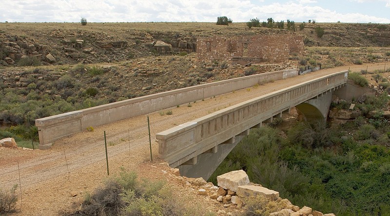
Constructed in 1915, this bridge was later incorporated into Route 66 highway, a network of existing roads supplemented by additional construction to create a single road that stretched from Chicago to Santa Monica, California. At this location, travelers on Route 66 crossed over Canyon Diablo using this bridge until 1938, when a road realignment led to the construction of a new bridge. The former town of Two Guns arose next to the bridge and became a popular tourist stop along the highway. The bridge was built of steel and concrete and features a cantilevered roadway and two parapet walls, one of which is solid to protect the roadway from floods, and the other is slotted to allow water to flow out. Route 66 was eventually superseded by Interstate Highway 40. Today, the bridge is surrounded by ruins of former buildings that once lined Route 66. The structure has not been connected to an active road for many decades but it is listed on the National Register of Historic Places and remains historically significant as an early example of an automobile bridge in Arizona.
Images
The Canyon Diablo Bridge was built in 1915 as part of the National Old Trails Road, which later became Route 66.
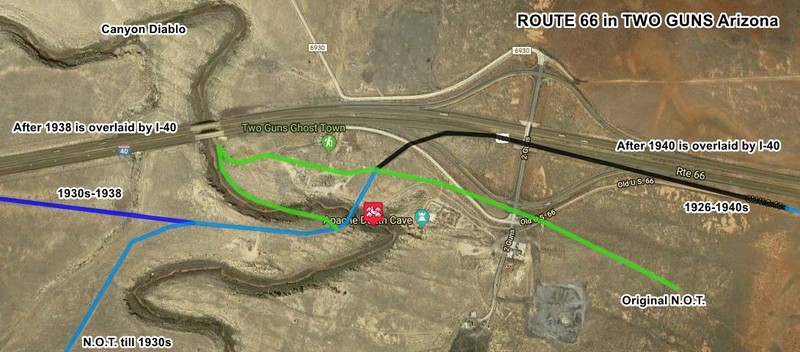
Map showing the evolution of the roadways at Two Guns.
Backstory and Context
Text-to-speech Audio
Native American artifacts dating from 1050 to 1600 A.D. have been discovered in the Two Guns area. In 1878, Apache and Navajo Indians engaged in a violent confrontation when Apache warriors attacked a Navajo camp and killed everyone except three girls who were taken as prisoners. Upon learning of the incident, Navajo warriors arrived and attacked the Apaches while they hid in a cave. The Navajo warriors lit a fire at the cave entrance and shot the Apache as they tried to escape. The nearby cave is known as the "death cave."
American settlers started to arrive in the mid-1800s. By then, they realized that this location at Canyon Diablo was the best spot for wagons to cross it. In the early 1900s, homesteaders acquired claims in the area. In 1914, two years after the National Old Trails Road (the predecessor to Route 66) was established, the site was surveyed to build the bridge. It opened to traffic on March 17, 1915. The town of Two Guns became a tourist stop thanks to the bridge. Stores, gas stations, and lodging accommodations were built for travelers. The town was eventually named after Henry "Two Guns" Miller, who was allegedly part Apache and Mohawk Indian. He called himself "Chief Crazy Thunder" and built a zoo for tourists. In 1926, he shot and killed a resident of the town, Earl Cundiff. Remarkably, Miller was acquitted and left town.
The bridge was only used until 1938, when a new one was built just to the northeast when Route 66 was realigned. That course was later replaced by I-40. Ruins and abandoned buildings are all that remain of Two Guns. Unlike many other Route 66 towns that didn't survive when I-44 bypassed them, Two Guns lived on for a time. Modern amenities, including a gas station, coffee shop, motel, and gift shop were built. The zoo was rebuilt as well. However, these went out of business around the 1970s
Sources
"Canyon Diablo Bridge." Historic American Buildings Survey//Historic American Engineering Record, National Park Service. https://npgallery.nps.gov/AssetDetail/NRIS/88001664.
"Two Guns, Arizona - Death By Highway." Legends of America. Accessed September 30, 2023. https://www.legendsofamerica.com/az-twoguns.
"Two Guns." The Route-66.com. Accessed September 30, 2023. https://www.theroute-66.com/two-guns.html.
Wikimedia Commons: https://commons.wikimedia.org/wiki/File:Canyon_Diablo_Bridge_-_Two_Guns,_Arizona.jpg
Route-66.com