Diamond Head State Monument
Introduction
Text-to-speech Audio
Images
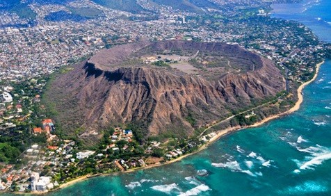
Diamond Head aerial view
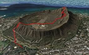
Diamond Head trail overview
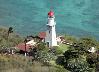
Diamond Head Light House
Backstory and Context
Text-to-speech Audio
The unique profile of Diamond Head (Lē‘ahi) sits prominently near the eastern edge of Waikiki’s coastline. Hawaii’s most recognized landmark is known for its historic hiking trail, stunning coastal views, and military history. Diamond Head State Monument encompasses over 475 acres, including the interior and outer slopes of the crater.
It is said that Hi‘iaka, sister of the fire goddess Pele, gave Lë‘ahi its name because the summit resembles the forehead (lae) of the ‘ahi fish. Another translation is “fire headland” and refers to the navigational fires that were lit at the summit to assist canoes travelling along the shoreline. The heiau (temple) built on the summit was dedicated to the god of wind as protection against strong updrafts that could put out these navigational fires. Today, the Diamond Head Light, built in 1917, provides a visual aid for navigation.
In the late 1700s, Western explorers and traders visited Lë‘ahi and mistook the calcite crystals in the rocks on the slope of the crater for diamonds. Thus, the name Diamond Head became the common name for the crater.
This broad, saucer-shaped crater was formed about 300,000 years ago during a single, explosive eruption that sent ash and fine particles in the air. As these materials settled, they cemented together into a rock called tuff, creating the crater, and which is visible from the trail in the park. Most of the vegetation and birds were introduced in the late 1800s to early 1900s.
The trail to the summit of Lē‘ahi was built in 1908 as part of O‘ahu’s coastal defense system. The 0.8 mile hike from trailhead to the summit is steep and strenuous, gaining 560 feet as it ascends from the crater floor. The walk is a glimpse into the geological and military history of Diamond Head. A concrete walkway built to reduce erosion shifts to a natural tuff surface about 0.2 mile up the trail with many switchbacks traversing the steep slope of the crater interior. The ascent continues up steep stairs and through a lighted 225-foot tunnel to enter the Fire Control Station completed in 1911.
Built on the summit, the station directed artillery fire from batteries in Waikiki and Fort Ruger outside Diamond Head crater. At the summit, you’ll see bunkers and a huge navigational lighthouse built in 1917. The postcard view of the shoreline from Koko Head to Wai‘anae is stunning, and during winter, may include passing humpback whales (Department of Land and Natural Resources, Division of State Parks, 2016).