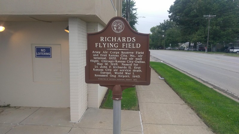
Richard's Flying Field Historical Marker
Introduction
Text-to-speech Audio
This historical marker near the Gregory Hines subdivision shares the story of a former airfield named for Lt. John F. Richards II, the first Kansas City soldier in the Army's air service to perish in Europe during World War I. The airfield served Raytown for roughly three decades with the Army Air Corps managing the runway and field. The airfield was used for training along with airshows, and short-lived airmail service. In an era before regular schedules and major airlines, commercial aircraft from all over the country also landed in Raytown at Richard's Field. The Gregory Hines subdivision replaced the airfield during the 1950s. Similar to the airfield's connection to World War II, this development was connected to the major wars of the 20th century as the suburban sprawl that led to the expansion of Kansas City coincided with troops returning from World War II looking for homes.

Images
Richard's Flying Field Historical Marker
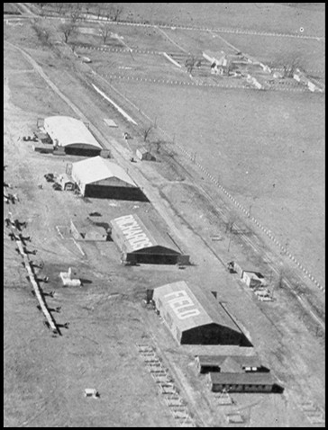
Two hangers show the words "Richards" and "Field" on their roofs. Photo date unknown.
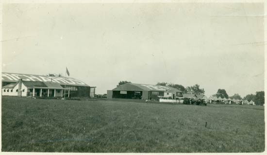
Richard's Flying Field. Photo taken 1922.
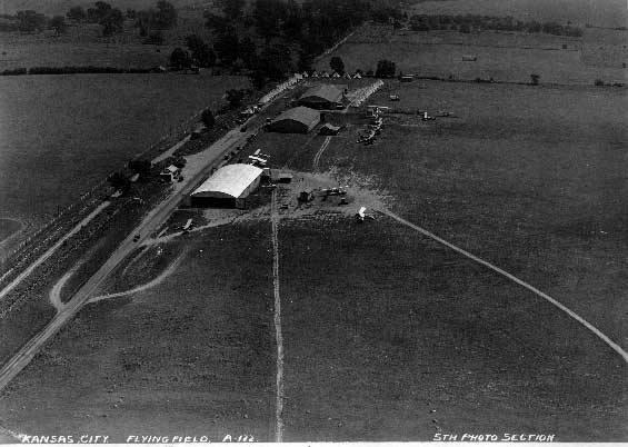
Richard's Flying Field. Photo believed to have been taken in 1922.
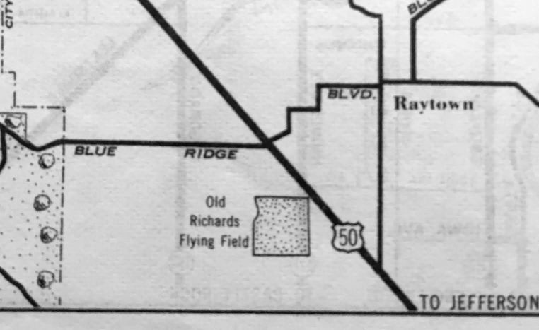
1938 Street Map that included Richard's Flying Field
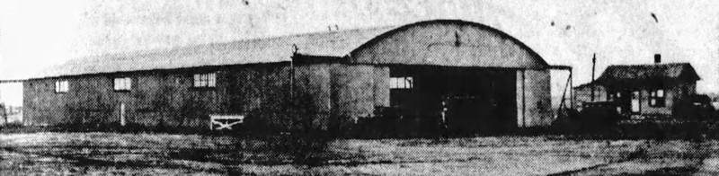
An undated photo of an Old Richards Airport hangar from a 5/11/37 newspaper article
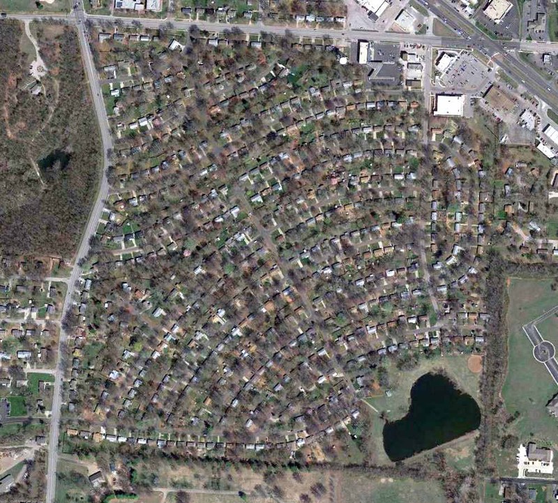
Gregory Hines subdivision, which was built on the land that once hosted Richard's Flying Field
Backstory and Context
Text-to-speech Audio
Once home to the Osage Indians, modern-day Raytown later became a Santa Fe Trail stop which spread awareness of the desirable farmland here. The town's namesake, William Ray, born in Butler County, Ohio, in 1808, moved to Jackson County around 1848 and established a Blacksmith shop right on the Santa Fe Trail; he routinely repaired wagons before settlers traveled westward along the trails. Ray became a fixture in the town, and his business became a geographic landmark. Residents often referred to the community as "Ray's Town" and eventually, "Raytown."
The town developed slowly as a farm community, including slave-operated plantations. However, the Civil War disrupted Raytown's growth until the 1870s. From 1877 to the early 1900s, the principal occupations consisted of grain farming, cattle raising, and dairying. Raytown grew in conjunction with Kansas City's maturation into an urban center. And in 1903, the arrival of the railroad into Raytown helped bolster its own growth and by the 1920s, people could fly to and from Raytown.
In 1922, the city constructed a 1,500-foot runway on 156 acres of land, which the U.S. Army controlled after its completion. The Army called it Richard's Flying Field in honor of Lt. John F. Richards II, the first Kansas City officer to die while in the Army flying service. In addition to serving as a flight training facility -- Charles Lindbergh received some of his early training at Richards Field; roughly thirty planes per month landed in Raytown from 1922-to 1924. By 1925, several hundred planes stopped there each month, often to refuel during longer continental flights.
By 1926, the airport served as one example of Raytown's evolution into a small urban community. Tourists arrived via the airfield and on newly-paved roads; many came to watch airshows at Richard's Flying Field. New homes, churches, and schools also served as signs of the town's growth. The airport also served as an airmail stop from 1926 to 1927, before the airmail contract transferred to K.C. Municipal Airport. But, the opening of Kansas City's airport in 1927 also points to the broader story of the area's urban history: Raytown evolved into a suburb.
By 1949, William Ong purchased the airfield and renamed it Ong Airport. After the military (Army, Navy, and Marines) used the airport for training pilots during World War II, the remaining training aircraft were transformed into crop dusters. In 1952, the town subdivided the airport into 405 lots for homes, now known as the "Gregory Heights" subdivision. The repurposing of this land demonstrates the suburban sprawl and construction boom that followed World War II.
Cite This Entry
Powers, Mathew and Clio Admin. "Richard's Flying Field Historical Marker." Clio: Your Guide to History. April 22, 2022. Accessed March 23, 2025. https://theclio.com/entry/148953
Sources
Herriges, Daniel. "Kansas City's Fateful Suburban Experiment." strongtowns.org. May 6, 2020. https://www.strongtowns.org/journal/2020/5/5/kansas-citys-fateful-suburban-experiment.
"History." Raytown Chamber of Commerce. raytownchamber.com. Accessed April 20, 2022. https://raytownchamber.com/history/.
"Richard's Field, Kansas City, MO. Fairfax Field, Kansas City, KS." Davis-Monthan Aviation Field Register: First Municipal Aviation Field in the U.S. dmairfield.org. September 11, 2015. https://dmairfield.org/places/kansascity_mo/
Sanchez, Michael E., Jr. "Richards Flying Field." The Historical Marker Database. HMdb.org. September 30, 2019. https://www.hmdb.org/m.asp?m=140273.
Photographed By Michael E Sanchez, Jr., September 28, 2019. https://www.hmdb.org/m.asp?m=140273
https://dmairfield.org/places/kansascity_mo/
https://dmairfield.org/places/kansascity_mo/
Kevin Walsh, found at: http://www.airfields-freeman.com/MO/Airfields_MO_NW.htm#oldrichards
Alexa Lausen, found at: http://www.airfields-freeman.com/MO/Airfields_MO_NW.htm#oldrichards
http://www.airfields-freeman.com/MO/Airfields_MO_NW.htm#oldrichards