Eucalyptus Overlook
Introduction
Author-Uploaded Audio
Listen to a narration of this entry's description by Nicky Rehnberg.
Text-to-speech Audio
Recommended Time: 15 minutes
Walk back up to Ellwood Mesa and walk along the coastal bluffs, away from Isla Vista. Pay attention to how the coastline around you changes as you walk. Stormy weather can drastically change its shape and form. For your safety, find an obviously well-grounded spot and look down at the beach. What do the sides of the bluffs look like? Does it seem like some of the geology that made up the top of the bluff shifted? What kinds of plants do you see down there?
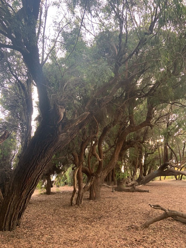
Get ready to see more eucalyptus! When you approach this new grove, walk into it and towards the water. I am not leading you astray or to your doom, do not worry.
Look at the roots of the trees. How are they shaped? How much of them can you see? The roots of these trees can spread across over 100 feet, and they are not shy. You can likely see (or nearly be tripped by) many of them. Walk carefully! I have gotten many bruises from these trees. Eucalyptus roots suck up as much water as they can, and when they do, they can dehydrate other plants. Do you see any other plants among the eucalyptus? If you do, they are probably small, or you may have mistaken a smaller sprout of Eucalyptus as a separate plant. Look for where it is rooted because that is its home.
As you walk toward the water, you will see an opening. Go towards it and step onto this overlook. This is a beautiful spot. I have seen so many graduation and engagement sessions – even a full wedding – right here. Typically this is at “golden hour,” the hour or so before sunset. Maybe you timed this tour to see it at sunset. Either way, look out in the water. What do you see? When I walk out here, I always see a lot of history.
When you have taken the proper number of selfies and panoramas, read the next section.
Images
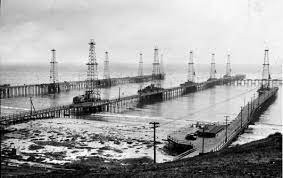
Goleta Oil Field, 1940s
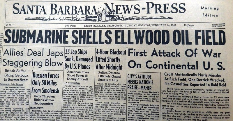
Santa Barbara News-Press Headline of Ellwood Attack
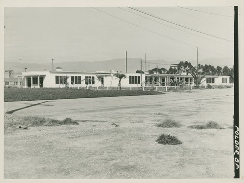
Marine Base and Future Site of UCSB
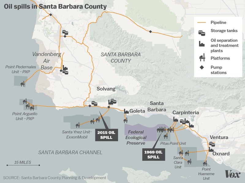
Map of Santa Barbara Oil Spills
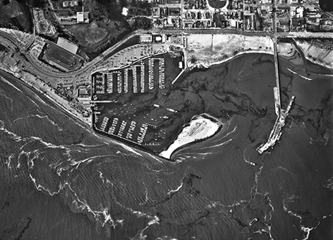
Santa Barbara Oil Spill, Aerial View
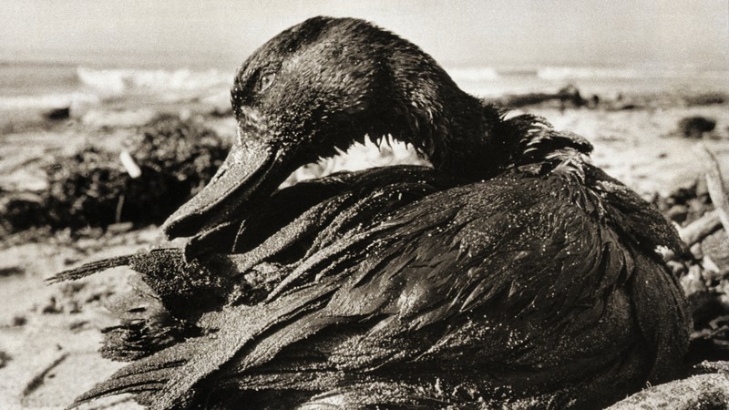
Duck Covered in Oil
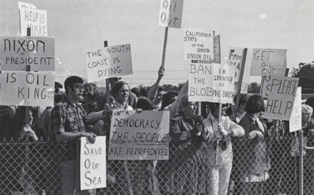
Protests against Santa Barbara Oil Spill
Eucalyptus Overlook
Backstory and Context
Author-Uploaded Audio
Listen to a narration of this entry's description by Nicky Rehnberg.
Text-to-speech Audio
Look out at the water. You likely see several oil rigs out in the water. Some have been there for over 60 years, but the history of oil extraction in this area, as you already know, goes back over 120 years!
So, let’s time travel to a couple of different times, so you can understand oil extraction on this coast as a process.
Imagine it is 1900. You are on this bluff, and it is hundreds of feet towards the water at that time. You look at the beach below and you see a lot of small piers. These are called catwalks as their small width makes its walkers look like cats. These piers begin at the shore and go into the ocean, towards the oil seeps with the most natural leakage. The one you would see at this immediate spot was owned by the Bolsa Chica Oil Company, which built a 900-foot pier into the sea and drilled 4,700-feet below. Oil workers would use the catwalks to stand above the oil seeps and take a pipe with an attached weight and manually bring the pipe up and down to bring oil up. It would flow through pipes, usually placed on the piers, towards the shore for processing. You could say it was a crude way to extract the crude oil. (As a historian, I can confirm that bad jokes are timeless.)
And now it’s the late 1920s and early 1930s, when oil industries began to swarm the coast. Where there were once only a few catwalks, the whole coast seemed to be covered with little piers and pipes, allowing oil workers and their new equipment to take out even more oil. The Ellwood Field, near here, produced over 1 million barrels in just the first quarter of 1929.
Wells were drilled onshore as well, where there was also an abundance of oil storage and processing facilities, some of which you can see between the Coal Oil Point Pond Trail and Eucalyptus Grove sites. Much of the early drilling in this area was short-lived, though. By the early 1940s most production in this immediate area moved offshore.
Going a decade forward, there were some other big things happening in the US in the 1940s. Primarily, the US entered World War II. After the attack on Pearl Harbor, coastal communities on the mainland worried about similar attacks. Beginning in 1940, as an illustrative example, the Campbells sought to sell their property.
Unfortunately, it was even harder to find a buyer after a Japanese submarine surfaced off Ellwood Beach and lobbed 16 shells into the tidewater on February 23, 1942. Only one shell hit land, causing $500 in damage total. Following this incident, the Marine Corps created the Goleta Air Station that was commissioned on December 4, 1942, which trained squadrons for combat in the Pacific. Artillery and hangars were kept on the land that is now the Santa Barbara Municipal Airport, but a significant portion of the training areas and barracks were built on land that later became UCSB, as it transitioned from a state college to a campus of the larger University of California system in 1944.
Let’s jump forward in time one more time. It’s February 8, 1969. You are looking out on this overlook still. And while the water immediately below you look fine, looking toward the way you came; however, you see many little boats. The people inside of them are not fishing and they look upset. On January 28, 1969, there was a blow out on a major oil platform off of the coast of Carpinteria, twenty miles south of here. (It was the biggest oil spill at that time, only being replaced in 1989 with the Exxon Valdez spill). By February 8th, there were at least 80,000 to 100,000 barrels of crude oil spilled into the Santa Barbara Channel. You could not get away from the oil on the Santa Barbara coast, and it killed a lot of marine flora and fauna. We know, for example, that a lot of sea birds were killed, but this is most likely because their bodies could be found after their death. Approximately 3,500 birds died. Dolphins, elephant seals, and sea lions died in numbers we do not even know.
Coming back to the present, can you see any evidence of the coast’s oily history?
Exploration Questions
- What did you know about the history of oil extraction on the Santa Barbara coast before this tour? What about it surprised you? What are your opinions about offshore oil drilling, and are your thoughts impacted by being a student at UCSB?
- Imagine you are a UCSB student in 1969. Would you want to be involved in any oil spill clean-up efforts or other budding environmental efforts on campus? What would you want to do and why? Can you do any of those things now?
- What was the last oil spill that you heard about happening on southern California shores? How did you hear about it? What did you hear about it? Did you care about it at the time? Why or why not? If you haven’t heard about a recent oil spill, why do you think that was the case?
Sources
Modugno, Tom. "Attack on Ellwood." Goleta History. https://goletahistory.com/attack-on-ellwood/
Spezio, Teresa Sobol. Slick Policy: Evironmental and Science Policy in the Aftermath of the Santa Barbara Oil Spill. Pittsburgh: University of Pittsburgh Press, 2018.
https://goletahistory.com/attack-on-ellwood/
https://goletahistory.com/attack-on-ellwood/
https://calisphere.org/item/efd8b0799df77ecfa72c3123db7c804d/
https://www.vox.com/2015/5/21/8636555/santa-barbara-oil-spill
https://response.restoration.noaa.gov/about/media/45-years-after-santa-barbara-oil-spill-looking-historic-disaster-through-technology.html
https://www.npr.org/2019/01/28/688219307/how-californias-worst-oil-spill-turned-beaches-black-and-the-nation-green
https://www.edhat.com/news/1969-oil-spill-re-examined-at-ucsb
Picture by Nicky Rehnberg