Toledo War Historical Marker: The "War" With a Happy Ending
Introduction
Text-to-speech Audio
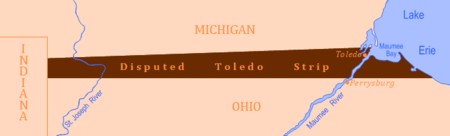
This historical marker commemorates a nearly bloodless conflict in 1835 over tensions that surfaced largely due to shortcomings of geographical precision in drawing territorial lines. Along what is now the Ohio-Michigan border, Michigan militia made their headquarters during the Toledo War, which is also referred to as the Ohio-Michigan War. This heated dispute began when Congress drafted the Northwest Ordinance, stating that 260,000 square miles of territory around the Great Lakes would eventually become new states. In addition, this ordinance stated that the border between Michigan and Ohio was to be “an east and west line drawn through the southerly bend or extreme of Lake Michigan” and then intersect with Lake Erie. Unfortunately, because of the limited knowledge about the area at the time, the best map (known as the “Mitchell Map”) depicted Lake Michigan’s tip as being much farther north. Because of this, the border at the bottom of Lake Michigan made Toledo part of Ohio, though wrongly so. This erroneous information led to the “war” that would be peacefully resolved. Under federal pressure, Michigan Territory agreed to cede the Toledo Strip to Ohio. In return, Michigan was granted statehood and the western three-quarters of what is known today as the Upper Peninsula.

Images
This historical marker was located here for many years before the marker disappeared.

Far view from the monument, which may be difficult to see among the trees as shown in Google Maps in 2023.

Backstory and Context
Text-to-speech Audio
The area in question is a 468-square-mile strip along the Ohio-Michigan border, now known as the “Toledo Strip.” On its eastern side was the mouth of the Maumee River, providing excellent inland shipping opportunities, and to the western side of the strip was rich land perfect for developing agriculture. Toledo was also the planned end point of the Miami and Erie canals, which, according to Ohio, would help develop Toledo into a booming metropolis. The issue regarding Lake Michigan’s wrongful location was supposedly brought up by a hunter at the Ohio constitutional convention in 1802. The hunter stated that the lake was further south than the maps depicted.
In 1803, Ohio was admitted to the United States and claimed in its constitution that it owned the land around the Maumee no matter what future surveys might show. Disregarding this, Congress created Michigan Territory in 1805, using the Northwest Ordinance to define the territory’s southern boundary and giving Michigan a chance to lay claim to the Toledo Strip.
In 1812, after a period of inactivity regarding control over the the Toledo Strip, the Ohio government convinced Congress to officially survey the border. However, with the outbreak of the War of 1812, the survey was delayed until 1816 when U.S. Surveyor General Edward Tiffin, a former Ohio governor, sent William Harris to conduct the survey. When finished, Harris constructed the “Harris Line," which placed the mouth of the Maumee River in the state of Ohio as claimed in its constitution. When the results were made public, Michigan territorial governor Lewis Cass objected, and commissioned a second survey that was carried out by John A. Fulton. The results of said survey (known as the “Fulton Line”) found the Ohio boundary to be southeast of the Maumee River. The region between the Harris and Fulton survey lines is what became the Toledo Strip, which was claimed by Ohio. However, Michigan disregarded this and held elections, built roads, and collected taxes in the Toledo Strip.
Congress had to settle the border dispute before Michigan could become a state, with representatives from Ohio working to block statehood unless it ended its claim to the area. A heated debate occurred in 1835 when the territorial governorship of Michigan was granted to a hot-blooded 23-year-old politician named Stevens T. Mason, who wasted no time in asserting his authority over the strip: “We are the weaker party, it is true,” he proclaimed, “but we are on the side of justice…we cannot fail to maintain our rights against the encroachments of a powerful neighboring state”.
Mason passed the “Pains and Penalties Act” in February of 1835, which levied harsh fines and jail time to any Ohio officials who attempted to exercise authority over the Toledo Strip. Not one to be strong-armed, Ohio Governor Robert Lucas passed a resolution extending their county borders into the strip while also sending a team of surveyors remark the boundary. Tensions came to a head, and the governments of the state of Ohio and Michigan Territory both raised militias to protect their claim.
On April 9th, 1835, Michigan took the enforcement of their “Pains and Penalties Act” to heart, sending a posse led by a Michigan Sheriff into Toledo to arrest several Ohio state officials. Newspapers even state that an Ohio flag was dragged through the street and burned. Robert Lucas again sent out surveyors to mark the Harris Line. On April 26th, the surveyors were ambushed by a team of 60 Wolverine partisans led by Michigan militia leader General Joseph Brown. Though nobody was injured in this exchange (known today as the “Battle of Phillips Corners”), the Michigan militia confronted the surveyors, fired shots over their heads, and arrested nine of their party members.
Although this particular battle did not incur any casualties, it would not be long before blood was shed over the Toledo Strip. In July 1835, the Toledo War’s sole casualty, Michigan Sheriff Joseph Wood, entered Toledo to arrest Ohio partisan named Two Stickney. Sheriff Wood and his posse confronted Stickney in a tavern. During the brawl that ensued, Stickney stabbed Wood with a penknife. Although Wood was not severely injured and recovered from his stab wound, this event set the tone for even more bloodshed.
In the fall of 1835, Governor Lucas stated that he would hold a court session in Toledo to lay Ohio’s claim to the Toledo Strip. In response, Michigan Governor Mason marched 1,200 Wolverine militiamen into the Toledo Strip to prevent the court session from happening. The troops arrived on September 7th to discover that the Ohio men had already held a secret midnight court session and fled the area.
Following the advice of Congress, President Andrew Jackson decided to end the conflict with a compromise. On June 15th, 1836, Jackson signed a bill that allowed Michigan to become a state, but only if they ceded the Toledo Strip to Ohio. In return, Michigan would gain the western three-quarters of what is known today as the Upper Peninsula. At first, Michigan aggressively rejected Jackson’s offer, as the Upper Peninsula was widely considered useless to Michigan. However, having created a financial crisis because of high militia expenses, Michigan was spurred into action because the United States Treasury had a $400,000 surplus to be distributed to the current 25 states (but not to territories). On December 14th, 1836, a convention held in Ann Arbor decided to accept Congress’ terms, and on January 26th, 1837, Michigan was admitted as the 26th state.
Though Michigan didn’t keep the Toledo Strip, the new state did get the entire Upper Peninsula, which proved to contain vast amounts of wood, iron, and copper. For both Ohio and Michigan, this made the conflict a "war" with a happy ending.
Cite This Entry
Madison Schmitt and Clio Admin. "Toledo War Historical Marker: The "War" With a Happy Ending." Clio: Your Guide to History. December 11, 2023. Accessed April 1, 2025. https://theclio.com/entry/175495
Sources
Allberry, James. The Toledo War – Summer of 1835, Military History of the Upper Great Lakes. November 20th, 2015. Accessed December 2nd, 2023. https://ss.sites.mtu.edu/mhugl/2015/11/20/the-summer-of-1835-the-toledo-war/.
Andrews, Evan. The Toledo War: When Michigan and Ohio Nearly Came to Blows, History.com. November 21st, 2016. Accessed December 2nd, 2023. https://www.history.com/news/the-toledo-war-when-michigan-and-ohio-nearly-came-to-blows.
Benington, Dale. "War" With Happy Ending, The Historical Marker Database. July 17th, 2009. Accessed December 2nd, 2023. https://www.hmdb.org/m.asp?m=21010.
Michigan History Center Staff. The Toledo War, Michiganology. Accessed December 2nd, 2023. https://michiganology.org/stories/the-toledo-war/.
The Toledo War, Military and Veterans Affairs. Accessed December 2nd, 2023. https://www.michigan.gov/dmva/about/history/military-events/highlights/the-toledo-war.
Toledo War, Ohio History Center. Accessed December 2nd, 2023. https://ohiohistorycentral.org/w/Toledo_War.
Toledo War, Wikipedia. Accessed December 2nd, 2023. https://en.wikipedia.org/wiki/Toledo_War.
The Historical Marker Database
The Historical Marker Database