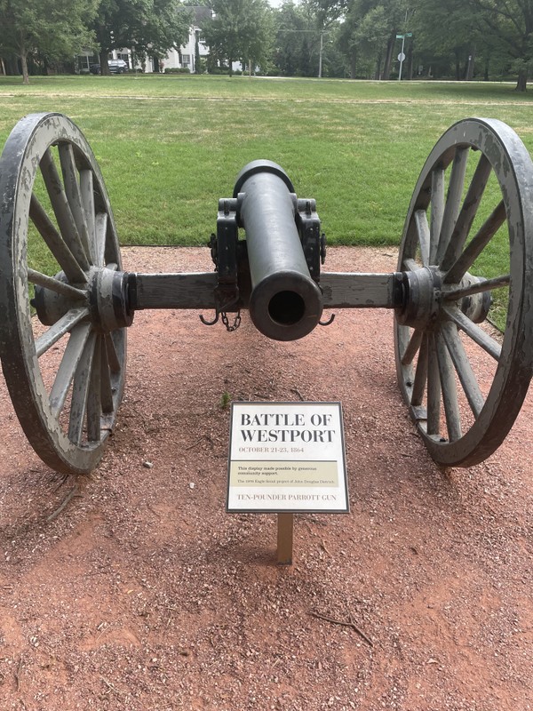
Replica Canon at Loose Park Historical Markers Tour Stop 8 (Battle of Westport Driving Tour) (Price's Raid)
Introduction
Author-Uploaded Audio
00:00 / 00:00
Dr. William Worley offers a short summary of the Battle of Westport and its significance
Text-to-speech Audio
These historical markers share information about the Battle of Westport, the most consequential battle fought west of the Mississippi River during the Civil War. The battle raged over two days throughout this part of what is now Kansas City, and while the precise location of all troop movements and engagements are not known, some of the most critical locations of the battle can be identified because of topography. For example, the land that is now home to the Pembroke Hill School was the high ground initially occupied by Confederates but captured by Union forces. The land that is now home to Loose Park was near the center of several known engagements and may have likely been used as an encampment and staging ground by Confederate troops in the early stages of the battle. Given the popularity of the park and its walking path, local historians chose this location for the replica cannon and a variety of detailed historical markers that were installed as part of an Eagle Scout project. For those who want to learn more about the Battle of Westport, there are many other historical markers connected to the 25-stop Battle of Westport tour.

Images
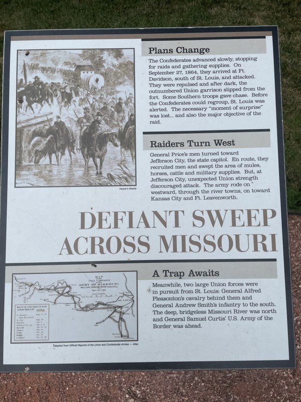
The first of the cluster of eight interpretive signs from left to right

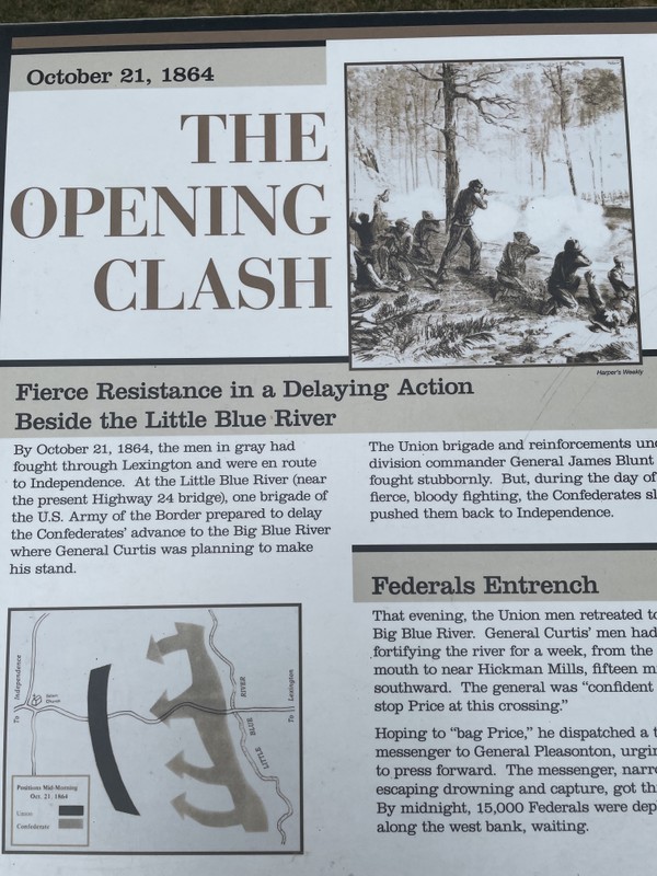
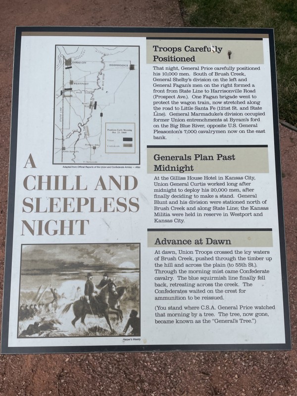
The second of eight interpretive signs from left to right
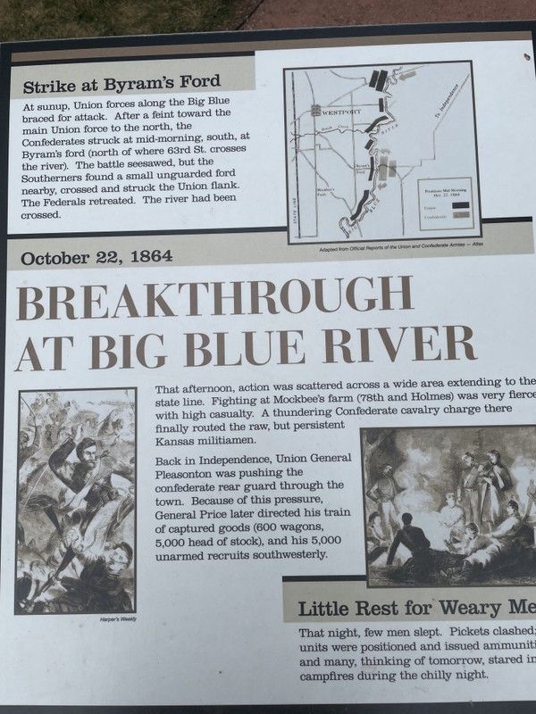
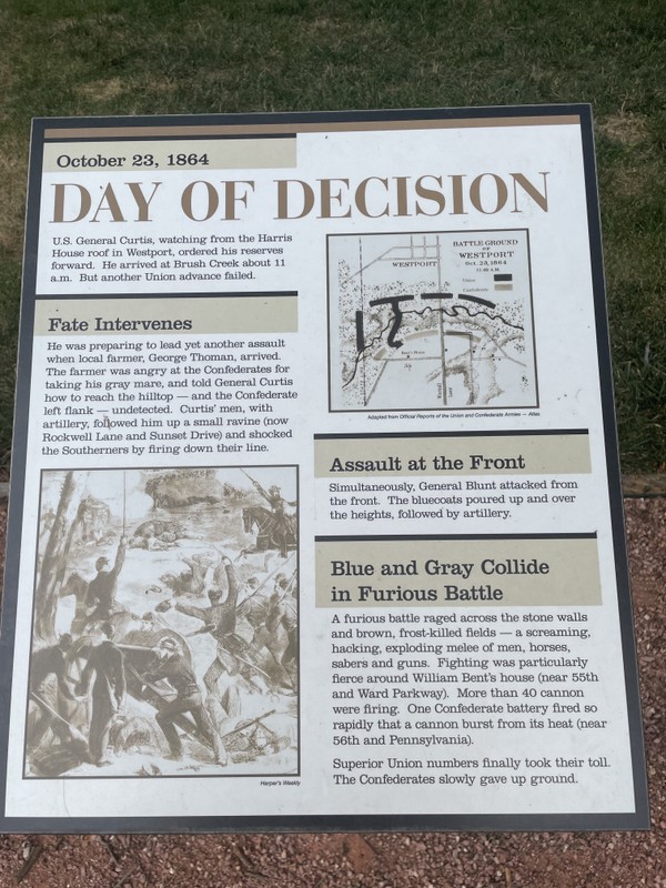
The third of eight interpretive signs from left to right
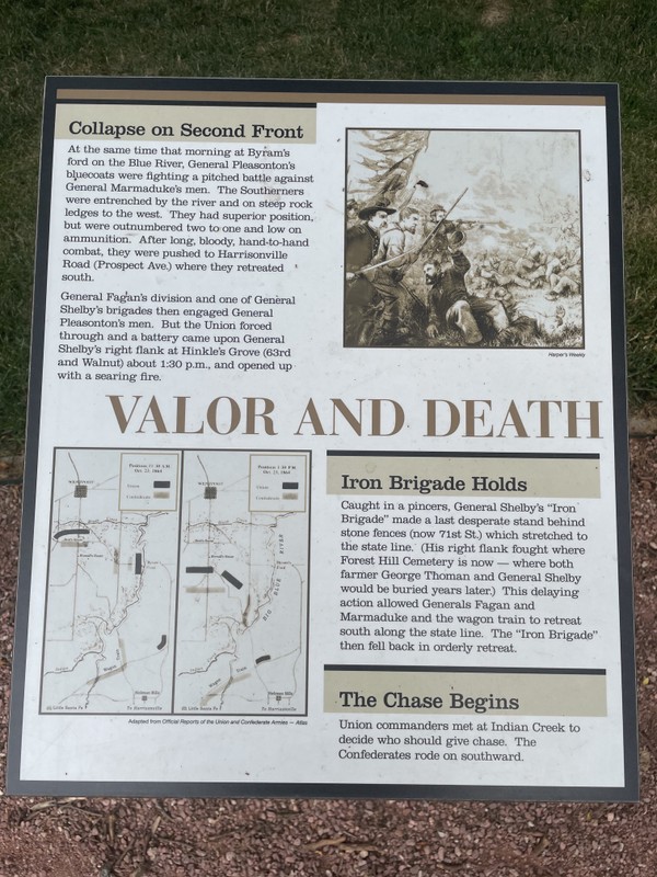
The fourth of eight interpretive signs from left to right
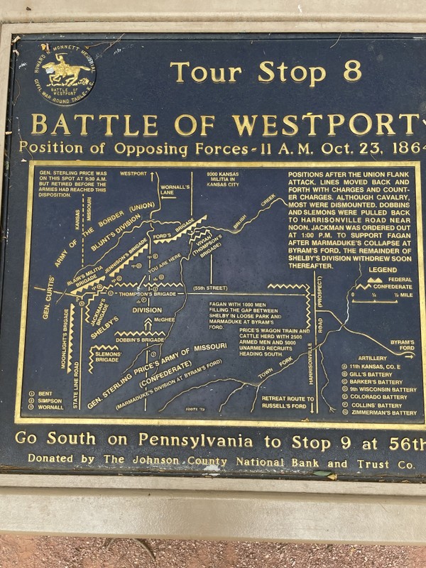
Part of a series of historical markers in the area, this sign includes a map showing Union and Confederate positions
This replica Civil War era cannon was funded with community support and was part of an Eagle Scout project in 1976
The fifth of eight interpretive signs from left to right
The sixth of eight interpretive signs from left to right
The eighth and final interpretive sign from left to right

Backstory and Context
Text-to-speech Audio
The Battle of Westport was the largest and one of the last battles to occur west of the Mississippi River in the Civil War. Local historians sometimes refer to this battle as "The Gettysburg of the West" because of the battle’s similarities to the Confederate strategy. The Battles of Westport and Gettysburg were both planned by the Confederate War Department as a means of taking the war to Union-controlled states in hopes of rallying Southern sympathizers and forcing the United States to defend their territory in addition to trying to take and hold ground in the South.
The largest stage of the Battle of Westport took place on October 23, 1864, when soldiers fought along a mile front that included modern-day Loose Park. The Union outnumbered their invading enemy 2:1 with 20,000 troops compared to the Confederates' 10,000 troops. The Confederate plan fell apart almost immediately due to the Union having superior numbers and the strategic advantage of being on the defensive in a territory they controlled. Union troops were able to open up two fronts on the Confederate invaders, quickly breaking their lines which forced a retreat. Small contingents of Union troops attempted to capitalize on their success and capture the retreating Confederates, and while Confederate forces were able to escape and regroup, subsequent clashes saw additional Union victories and the Confederacy never again seriously threatened the area similar to how Gettysburg marked the last attempt to invade Pennsylvania. The Battle of Westport effectively ended the Confederate's campaign in the West. While both sides sustained roughly the same number of casualties, 1,500 men, the loss was harder for the Confederates as these losses accounted for around twenty percent of their effective force while the Union only lost ten percent and the attack galvanized local support.
In the decade that followed, the land where Loose Park is now located became home to Kansas City Country Club, one of the city’s first country clubs. Developer J.C. Nichols bought the land surrounding the club to create the Country Club Plaza, and as single-family homes and businesses moved into the area, the country club moved to a new location on the Kansas side of the growing community. This land was sold to Ella Loose, who wanted to create a park out of the site that honored her husband, Jacob Loose. The park has been operated by Kansas City, Missouri and remains the third-largest in the city.
Cite This Entry
University of Kansas et. al. "Replica Canon at Loose Park Historical Markers Tour Stop 8 (Battle of Westport Driving Tour) (Price's Raid)." Clio: Your Guide to History. December 18, 2024. Accessed April 21, 2025. https://theclio.com/entry/78566
Sources
“Battle of Westport Visitor Center.” Battle of Westport Visitor Center and Museum, www.battleofwestport.org/VisitorCenter.htm.
Hart, John. “Under Moonlight in Missouri: Private John Benton Hart’s Account of Price’s Raid, October 1864.” Kansas History, vol. 37, no. 3, Sept. 2014, pp. 180–199. EBSCOhost, search.ebscohost.com/login.aspx?direct=true&db=a9h&AN=109374146&site=ehost-live.
Jenkins, Paul Burrill. Battle of Westport. Franklin Hudson, 1906.
“Monnett Battle of Westport Fund.” Civil War Round Table of Kansas City - Monnett Battle of Westport Fund, cwrtkc.org/monnett_battle_of_westport_fund.
Rafuse, Ethan S. “But for a Horse.” America’s Civil War, vol. 31, no. 5, Nov. 2018, pp. 34–41. EBSCOhost, search.ebscohost.com/login.aspx?direct=true&db=a9h&AN=131380781&site=ehost-live.
Photo by David Trowbridge
Photo by David Trowbridge
Photo by David Trowbridge
Photo by David Trowbridge
Photo by David Trowbridge
Photo by David Trowbridge
Photo by David Trowbridge
Photo by David Trowbridge
Photo by David Trowbridge