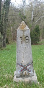
UCV Civil War Military Operations Marker #16: Blazer's Independent Scouts surprise Mosby's Rangers at Myer's Ford, September 4/5, 1864
Introduction
Text-to-speech Audio

Images
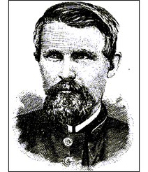
Captain Richard Blazer
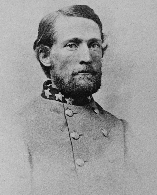
Colonel John S. Mosby
Section of 1862 map showing the fords near the property of Geo. Backhouse and Jacob Myers (Library of Congress)
.jpg)
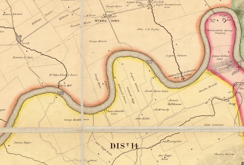
Section of c. 1861 map of Jefferson Co., Virginia, showing the locations of fords near Myerstown (Library of Congress)
.jpg)
1864 Map of Loudoun County and part of Clarke County, Va., Jefferson County and part of Berkeley County, W. Va., and parts of Montgomery and Frederick counties, Md
.jpg)
1864 Map of Loudoun County... (with mentioned locations marked)
Section of 1852 Jefferson County, VA map
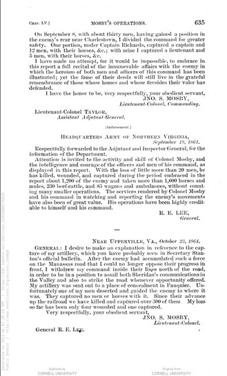
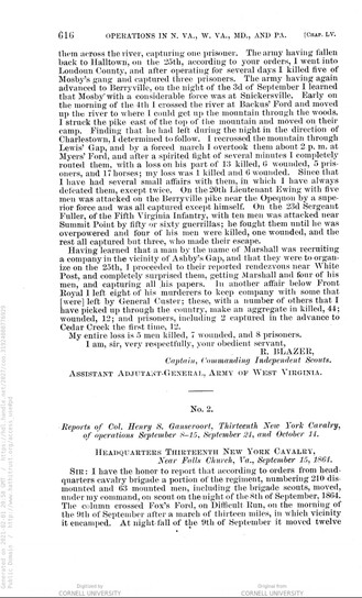
Report of Lieut. Col. John S. Mosby, page 1
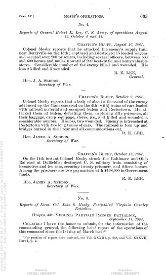
Report of Lieut. Col. John S. Mosby, page 2
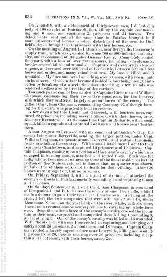
Report of Lieut. Col. John S. Mosby, page 3
Report of Capt. Richard Blazer, page 1
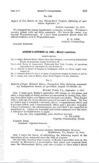
Report of Capt. Richard Blazer, page 1
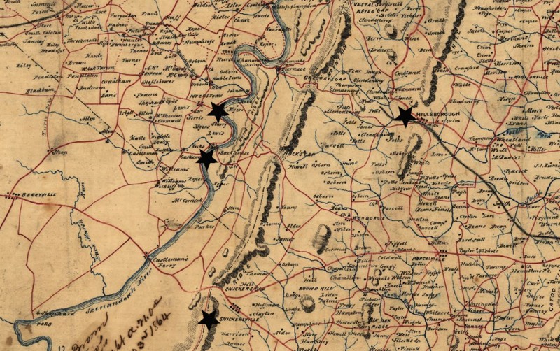
Map of obelisk locations
.jpg)
Backstory and Context
Text-to-speech Audio
During the 1864 Shenandoah Valley Campaign between Generals Philip Sheridan and Jubal Early, Confederate Lieutenant Colonel John S. Mosby and his raiders operated to harass Sheridan’s operations in the region. Mosby’s partisan-style attacks and ability to inflict damage and disappear earned him the name the “Gray Ghost” and his raiders were such a nuisance to Sheridan that he ordered a force of men picked and tasked with the goal of neutralizing Mosby in the Valley. This force was 100 picked men called the Independent Scouts led by Captain Richard Blazer.
On September 4 or 5, 1864 (the two reports give differing dates) Blazer’s scouts were able to capture part of Mosby’s force at Myers’ Ford near Myerstown. According to Mosby’s report, written September 11, 1864, on Sunday, September 5th he divided his rangers into three sections. He sent Companies C and E under Captain Sam Chapman to Berryville to harass the Union force there, he took six raiders with him towards Charles Town to do reconnaissance, and he left his other two companies (A & D) with Lieutenant Joseph Nelson on the east side of the Shenandoah River. Blazer’s report of October 24, 1864 stated that he learned of Mosby’s presence near Snickersville on the night of September 3. On the morning of the 4th he crossed the Shenandoah at Bachus’ Ford and went up river to where he could cross the mountains and access the pike east. When Blazer found Mosby’s campsite vacant and learned that the Raiders had headed towards Charles Town, he turned his men around and rode back to the Shenandoah, saying that they crossed the mountains at Lewis’ Gap. Blazer states that his men arrived at Myers’ Ford around 2:00 in the afternoon, surprising Mosby’s force resting by the river under the command of Lieutenant Nelson.
In Captain Blazer’s report of September 4, he reports the Union casualties as 1 killed and 4 wounded and Confederate casualties as 7 killed, 5 wounded, and 6 captured. In his report of October 24, the casualty numbers change slightly to 1 killed and 6 wounded on the Union side and 13 killed, 6 wounded, and 5 captured (plus 17 horses) for the Confederate side. The majority of Nelson’s men were able to scatter and retreat into Loudoun County, VA. The losses were slight for Mosby in comparison to the actions of his other men at the same time. In Mosby’s report he stated that his small force was able to capture 25 prisoners, 2 ambulances, and 18 horses at Charles Town while Chapman defeated a Union force near Berryville killing/wounding 15 and taking 30 Union prisoners.
Tracking the actual routes and locations of the engagement is slightly difficult. The UCV pamphlet lists Hillsboro as the location of Mosby’s camp; however, Blazer’s report states that his information placed Mosby at Snickersville. Also, location names were not standardized and locations often had multiple names. Backus’ Ford is likely the ford located near the property of George Backhouse and Myers’ Ford likely the crossing near the property of Jacob Myers. Lewis’ Gap does not match the names of the gaps in the Blue Ridge Mountains and Blazer does not specify if he rode to Snickersville or Hillsboro in his report.
About the Monuments:
This series of monuments and accompanying tour pamphlet were part of an initiative from the Jefferson County Camp, United Confederate Veterans to commemorate the 50th anniversary of the Civil War. In 1910 Col. R. Preston Chew and the Jefferson County UCV raised the funds to place 25 concrete obelisks in Jefferson County to mark locations of engagement or other significant events. The following year the Camp published a pamphlet to accompany the obelisks and give more information about each location. This was Military Operations in Jefferson County, Virginia (Now West Virginia), 1861-1865 published in 1911. The pamphlet has been reprinted several times by the Henry Kyd Douglas Camp, No. 199 of the Sons of Confederate Veterans. Because the monuments and accompanying pamphlet were done by Confederate veterans it is likely that the locations and descriptions are biased towards or favor the Confederate view and experience of the war.
Original Text from the 1911 Pamphlet:
"Marker Number Sixteen
Engagement at Myers Ford, Sunday, Sept. 5, 1864—Blazer’s and Mosby’s Men
Early Sunday morning, Sept. 5, 1864, Col. John S. Mosby, with companies A and B, of his command, broke camp in Loudoun county, near Hillsboro, and started for the Shenandoah Valley to reconnoiter in the vicinity of Charles Town. They passed through the Blue Ridge at Lewis’ Gap. On reaching the river at Myers Ford, Mosby with six of his men crossed the river to ascertain the strength of the enemy in and about Charles Town, leaving the remainder of the rangers in camp at the ford under Lieutenant Joseph Nelson. The men unsaddled their horses, and made themselves comfortable until they should have a report from Col Mosby.
Capt. Richard Blazer, of the 91st Ohio Infantry, temporarily in command of a company of picked men armed with long range seven shooters, pistols and sabers, the men being designated in the War Records, as Independent Scouts, on the morning of the same day, going from the direction of Charles Town, in search for Mosby’s men, crossed the river at Backus’ ford, above Shannondale, and proceeded over the mountain. They found the deserted camp of Mosby’s men near Hillsboro, where they were informed that Mosby had started with his men to the Valley. By a forced march, Blazer’s men followed the route taken by Mosby’s command, and surprised the camp at Myers ford. The men in camp being totally unprepared for an attack, scattered when the attack was made in all directions, the most of them having no time to saddle and mount their horses. Blazer’s report of the engagement that ensued states that one commissioned officer and four privates of the Confederate force were killed; one officer and six privates captured, and four wounded. In a later report he made the statement that 13 Confederates were killed, six wounded, five captured. Col. Mosby’s report showed that he lost one man killed, three wounded and three captured, while of Blazer’s command, one man was killed, three wounded and three were captured. Among the wounded Confederates was Lieut. Joseph Nelson, who was temporarily in command. After the fight Mosby’s command retreated into Loudoun county, and Blazer’s withdrew to the west side of the river."
Cite This Entry
Historic Landmarks Commission, Jefferson County and Kathleen Thompson. "UCV Civil War Military Operations Marker #16: Blazer's Independent Scouts surprise Mosby's Rangers at Myer's Ford, September 4/5, 1864." Clio: Your Guide to History. February 17, 2021. Accessed March 22, 2025. https://theclio.com/tour/1805/16
Sources
Bushong, Millard Kessler. A History of Jefferson County, West Virginia. Charles Town, WV: Jefferson Publishing Company, 1941.
Engle, Stephen Douglas. Thunder in the Hills: Military Operations in Jefferson County, West Virginia, During the American Civil War. Charleston, WV: Mountain State Press, 1989.
Military Operations in Jefferson County Virginia (and West Va.) 1861-1865. Published by Authority of Jefferson County Camp U.C.V. Farmers Advocate Print, 1911. Accessed January 20, 2021. https://babel.hathitrust.org/cgi/pt?id=uc2.ark:/13960/t4vh5gp6c&view=1up&seq=5.
“Reports of Lieut. Col. John S. Mosby, Forty-third Virginia Cavalry Battalion.” The War of the Rebellion: a Compilation of the Official Records of the Union and Confederate Armies. Series.1:vol.43:pt.1:Reports Correspondence. p. 633-635. Accessed February 1, 2021. https://babel.hathitrust.org/cgi/pt?id=coo.31924080776929&view=1up&seq=3
“Reports of Capt. Richard Blazer, Ninety-first Ohio Infantry, commanding Independent Scounts, of operations August 18-October 24.” The War of the Rebellion: a Compilation of the Official Records of the Union and Confederate Armies. Series.1:vol.43:pt.1:Reports Correspondence. p. 615-616. Accessed February 1, 2021. https://babel.hathitrust.org/cgi/pt?id=coo.31924080776929&view=1up&seq=3
"Blazer's Scouts." West Virginia in the Civil War. Accessed February 1, 2021. https://wvcivilwar.com/blazers-scouts/.
"John S. Mosby." Wikipedia. Accessed February 1, 2021. https://en.wikipedia.org/wiki/John_S._Mosby.
United States Topographical Bureau, and Samuel Howell Brown. Map of Jefferson County, Va. photographed for the Bureau of Topographical Engineers Oct. [S.l.: s.n., ?, 1862] Map. https://www.loc.gov/item/lva0000085/. Accessed February 2, 2021. https://www.loc.gov/resource/glva01.lva00085/?r=0.071,0.581,0.219,0.087,0.
Macomb, J. N. , 1810 Or 11-1889. Jefferson County, Virginia. [S.l.: s.n., ?, 1861] Map. https://www.loc.gov/item/lva0000084/. Accessed February 2, 2021. https://www.loc.gov/resource/glva01.lva00084/?r=0.237,0.786,0.564,0.225,0.
Brown, Samuel Howell, and Paul Hoffmann. Map of Loudoun County and part of Clarke County, Va., Jefferson County and part of Berkeley County, W. Va., and parts of Montgomery and Frederick counties, Md. [1864] Map. https://www.loc.gov/item/2004633831/. Accessed February 2, 2021. https://www.loc.gov/resource/g3883l.cwh00043/?r=0.055,0.359,0.749,0.299,0.
Brown, Samuel Howell, and Paul Hoffmann. Map of Loudoun County and part of Clarke County, Va., Jefferson County and part of Berkeley County, W. Va., and parts of Montgomery and Frederick counties, Md. [1864] Map. https://www.loc.gov/item/2004633831/. Accessed February 2, 2021. https://www.loc.gov/resource/g3883l.cwh00043/?r=0.055,0.359,0.749,0.299,0. Edits by Kathleen Thompson.
Map of Jefferson County, Virginia By S. Howell Brown from Actual Survey with the Farm Limits, 1852. WV GeoExplorer. Accessed February 2, 2021. http://www.wvgeohistory.org:8080/Portals/0/zoomify/URLDrivenPage2.htm?zImagePath=/Portals/0/zoomify/s_howell_brown_1852&zSkinPath=Assets/Skins/Default
“Reports of Lieut. Col. John S. Mosby, Forty-third Virginia Cavalry Battalion.” The War of the Rebellion: a Compilation of the Official Records of the Union and Confederate Armies. Series.1:vol.43:pt.1:Reports Correspondence. p. 633-635. Accessed February 1, 2021. https://babel.hathitrust.org/cgi/pt?id=coo.31924080776929&view=1up&seq=3
“Reports of Lieut. Col. John S. Mosby, Forty-third Virginia Cavalry Battalion.” The War of the Rebellion: a Compilation of the Official Records of the Union and Confederate Armies. Series.1:vol.43:pt.1:Reports Correspondence. p. 633-635. Accessed February 1, 2021. https://babel.hathitrust.org/cgi/pt?id=coo.31924080776929&view=1up&seq=3
“Reports of Lieut. Col. John S. Mosby, Forty-third Virginia Cavalry Battalion.” The War of the Rebellion: a Compilation of the Official Records of the Union and Confederate Armies. Series.1:vol.43:pt.1:Reports Correspondence. p. 633-635. Accessed February 1, 2021. https://babel.hathitrust.org/cgi/pt?id=coo.31924080776929&view=1up&seq=3
“Reports of Capt. Richard Blazer, Ninety-first Ohio Infantry, commanding Independent Scounts, of operations August 18-October 24.” The War of the Rebellion: a Compilation of the Official Records of the Union and Confederate Armies. Series.1:vol.43:pt.1:Reports Correspondence. p. 615-616. Accessed February 1, 2021. https://babel.hathitrust.org/cgi/pt?id=coo.31924080776929&view=1up&seq=3
“Reports of Capt. Richard Blazer, Ninety-first Ohio Infantry, commanding Independent Scounts, of operations August 18-October 24.” The War of the Rebellion: a Compilation of the Official Records of the Union and Confederate Armies. Series.1:vol.43:pt.1:Reports Correspondence. p. 615-616. Accessed February 1, 2021. https://babel.hathitrust.org/cgi/pt?id=coo.31924080776929&view=1up&seq=3
Military Operations in Jefferson County Virginia (and West Va.) 1861-1865. Published by Authority of Jefferson County Camp U.C.V. Farmers Advocate Print, 1911. Accessed January 20, 2021. https://babel.hathitrust.org/cgi/pt?id=uc2.ark:/13960/t4vh5gp6c&view=1up&seq=5.