UCV Civil War Military Operations Marker #24: Surrender of Harpers Ferry, September 15, 1862
Introduction
Text-to-speech Audio

Images
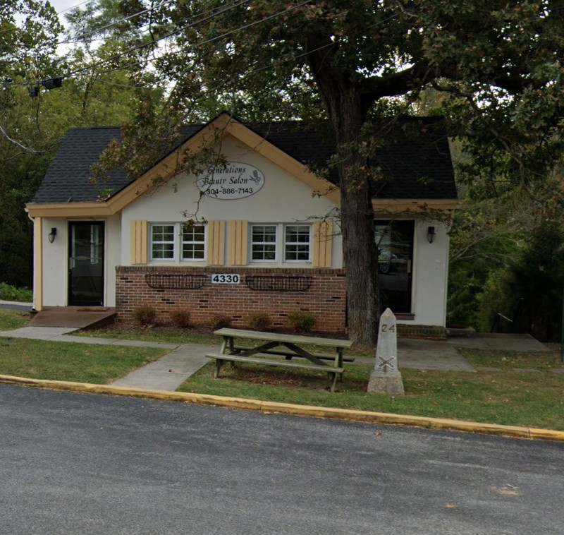
Obelisk #24
"Col. Dixon S. Miles at Harper's Ferry, W. Va." (Library of Congress)
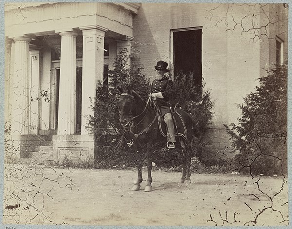
Col. Dixon S. Miles, c. 1860-1862
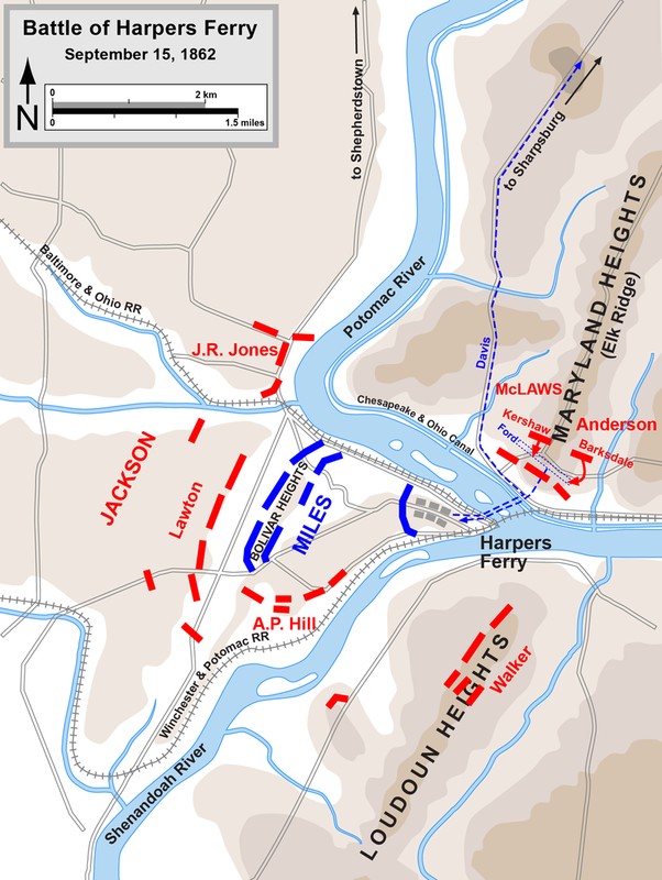
Battle lines on September 15, 1862 (map by Hal Jespersen)
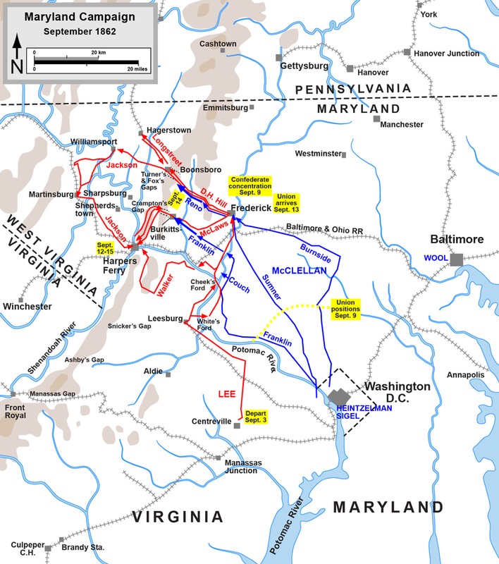
Lee's Maryland Campaign (map by Hal Jespersen)
Battle of September 13-15, 1862 (Map prepared by Steven Stanley, American Battlefield Trust)
.jpg)
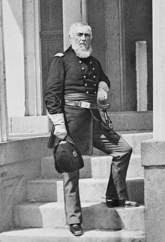
Confederate General Thomas J. "Stonewall" Jackson
.jpg)
Backstory and Context
Text-to-speech Audio
There are two UCV obelisks connected to the capture of Harpers Ferry in September 1862. Marker #22 commemorates the battle and Jackson's capture of Harpers Ferry. This obelisk commemorates more specifically the surrender (and death) of the Union officer in charge of Harpers Ferry, Colonel Dixon S. Miles. Miles was in command of Harpers Ferry from March 1862 through September and he was forced to surrender his entire force to Jackson in this battle. Just prior to surrendering Miles was struck in the leg by shrapnel from an artillery shell and died of his wounds the following day. In the aftermath of his surrender, Miles was heavily criticized for his command decisions leading up to the surrender of September 15, 1862.
Context:
During Confederate General Robert E. Lee’s 1862 Maryland Campaign, he divided his army into four sections to secure strategic points at Harpers Ferry, Martinsburg, and Boonsboro before reuniting his force to invade Maryland. Lee needed to remove the Federal presence from along the supply and communication lines needed to pursue his campaign north. This campaign ultimately resulted in the battles at South Mountain and Antietam, and Jackson’s capture of Harpers Ferry. General Lee ordered General Thomas J. “Stonewall” Jackson to capture the garrison at Martinsburg, VA and then take Harpers Ferry. After securing these two locations, Jackson’s force was to reunite with Lee’s main force in Maryland. His force of 14,000 troops left Lee at Frederick, MD on September 10th.
The Union had reoccupied Harpers Ferry in February 1862 to secure the communication and supply lines and protect the Shenandoah Valley. Union Colonel Dixon S. Miles with a force of 14,000 soldiers held the town. Harpers Ferry is a difficult location to defend. While the confluence of the rivers (and then the railroad lines) made it a good spot for an armory, the town was located on low ground surrounded by heights on three sides. A defense of Harpers Ferry relied on defending Bolivar Heights, Maryland Heights, and Loudoun Heights to prevent an enemy taking the high ground and firing down into the town. To defend against Jackson’s movement, Dixon divided his force into four brigades. His main force held Bolivar Heights with a section of militia holding Camp Hill, right outside the town proper. Miles sent a force of largely green troops to defend Maryland Heights and left Loudoun Heights undefended, believing that the Confederates would not be able to get artillery up to the top.
Jackson’s force converged on Harpers Ferry September 12-13, 1862. The wing under General Lafayette McLaws reached Maryland Heights first, on the 12th, and on the morning of September 13th pushed the Union force back. McLaws took Maryland Heights and placed heavy artillery there. Also on the 13th, a second force under General John G. Walker made it to the top of Loudoun Heights, where Miles had posted no Union force. This allowed the Confederates to take Loudoun Heights and place artillery there as well. The third wing, under Jackson, successfully cleared Martinsburg and made their way within miles of Bolivar Heights. General Miles and the Union force within Harpers Ferry were quickly being surrounded.
On the morning of September 14, artillery fire from Maryland Heights supported Jackson sending the division of A. P. Hill forward to Bolivar Heights. Miles had placed his main force there and Hill’s advance met strong resistance; however, by the end of the day the Confederates held Bolivar Heights and brought forward artillery to threaten the town. Jackson now held all three high points surrounding Harpers Ferry. September 15th was the Confederate’s final push. Jackson’s artillery fired into Harpers Ferry and then Hill’s infantry charged the Union position. Completely surrounded by Jackson’s force, Miles called together his officers to discuss surrender, during which Miles was mortally wounded by an artillery shell.
The Union surrender of Harpers Ferry on September 15, 1862 was the largest capture of Union forces during the Civil War, around 12,000 soldiers. Jackson did not stay long after his victory, however. Union General George B. McClellan had found a copy of General Lee’s plan for the invasion into Maryland and had followed him to Sharpsburg. As the stage was set for the battle of Antietam Lee needed Jackson’s force to return to the main army. Jackson left one division at Harpers Ferry, that of A. P. Hill, to handle the parole of prisoners and gathering up captured supplies and took the rest of his force towards Sharpsburg. Once that process was done, Hill’s division also headed towards Sharpsburg, arriving late on September 17th in the final stages of the battle.
About the Monuments:
This series of monuments and accompanying tour pamphlet were part of an initiative from the Jefferson County Camp, United Confederate Veterans to commemorate the 50th anniversary of the Civil War. In 1910 Col. R. Preston Chew and the Jefferson County UCV raised the funds to place 25 concrete obelisks in Jefferson County to mark locations of engagement or other significant events. The following year the Camp published a pamphlet to accompany the obelisks and give more information about each location. This was Military Operations in Jefferson County, Virginia (Now West Virginia), 1861-1865 published in 1911. The pamphlet has been reprinted several times by the Henry Kyd Douglas Camp, No. 199 of the Sons of Confederate Veterans. Because the monuments and accompanying pamphlet were done by Confederate veterans it is likely that the locations and descriptions are biased towards or favor the Confederate view and experience of the war.
Original Text from the 1911 Pamphlet:
"Marker Number Twenty-Four
The Point Where Federals Surrendered at Harpers Ferry
This stone was planted opposite the field in which the surrender of Miles took place. Miles was shot and killed opposite this stone near the summit of Bolivar Heights. He was struck just before the surrender and the command turned over to Genl. White. The surrender was remarkable because of the fact that Miles then had about 14,000 men. This great force capitulated almost without a struggle. Perhaps it was just as well for Miles that he met his death rather than to have to be branded with the disgrace of having made such poor resistance."
Cite This Entry
Historic Landmarks Commission, Jefferson County and Kathleen Thompson. "UCV Civil War Military Operations Marker #24: Surrender of Harpers Ferry, September 15, 1862." Clio: Your Guide to History. February 15, 2021. Accessed March 22, 2025. https://theclio.com/tour/1805/24
Sources
“The Battle of Harpers Ferry.” American Battlefield Trust. Accessed February 15, 2021. https://www.battlefields.org/learn/articles/harpers-ferry.
“Harpers Ferry – Bolivar Heights.” National Park Service. December 12, 2017. Accessed February 15, 2021. https://www.nps.gov/places/harpers-ferry-bolivar-heights.htm.
“Harpers Ferry and the Civil War Chronology.” Harpers Ferry National Historical Park. National Park Service. July 24, 2019. Accessed February 15, 2021. https://www.nps.gov/hafe/learn/historyculture/hf-civil-war.htm.
Hearn, Chester G. Six Years of Hell: Harpers Ferry During the Civil War. Baton Rouge: Louisiana State University Press, 1996.
Military Operations in Jefferson County Virginia (and West Va.) 1861-1865. Published by Authority of Jefferson County Camp U.C.V. Farmers Advocate Print, 1911. Accessed January 20, 2021. https://babel.hathitrust.org/cgi/pt?id=uc2.ark:/13960/t4vh5gp6c&view=1up&seq=5.
“Special Orders No. 191.” Monocacy National Battlefield. National Park Service. April 10, 2015. Accessed February 15, 2021. https://www.nps.gov/mono/learn/historyculture/so191.htm.
Google Maps. Accessed February 15, 2021.
“Harpers Ferry and the Civil War Chronology.” Harpers Ferry National Historical Park. National Park Service. July 24, 2019. Accessed February 15, 2021. https://www.nps.gov/hafe/learn/historyculture/hf-civil-war.htm.
"Dixon Stansbury Miles." Wikipedia. Accessed February 15, 2021. https://en.wikipedia.org/wiki/Dixon_Stansbury_Miles.
"Battle of Harpers Ferry." Wikipedia. Accessed February 15, 2021. https://en.wikipedia.org/wiki/Battle_of_Harpers_Ferry.
"Battle of Harpers Ferry." Wikipedia. Accessed February 15, 2021. https://en.wikipedia.org/wiki/Battle_of_Harpers_Ferry.
"Battle Map: Harpers Ferry - September 13-15, 1862." American Battlefield Trust. Accessed February 15, 2021. https://www.battlefields.org/learn/maps/harpers-ferry-september-13-15-1862.
"Stonewall Jackson." Wikipedia. Accessed February 15, 2021. https://en.wikipedia.org/wiki/Stonewall_Jackson.