The Tesar Home
Introduction
Text-to-speech Audio
In 1896, Bohemian Immigrant John Tesar and his wife Magdelina purchased a 50-acre property at the southern end of what is today Roeland Park, Ks. Here they operated a dairy farm for decades. The Tesar family became prominent in the nascent community of Southridge (today Roeland Park). They were founding members of the Southridge Presbyterian Church and John was on the board of Roesland School. The Tesar home, built around 1896 is the oldest surviving home in what is today Roeland Park. It has been renovated and expanded multiple times over the years.

Images
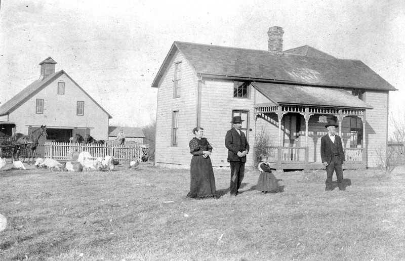
John, Magdelina, and Ana May Tesar circa 1900 in front of their home in what is today Roeland Park, Ks.
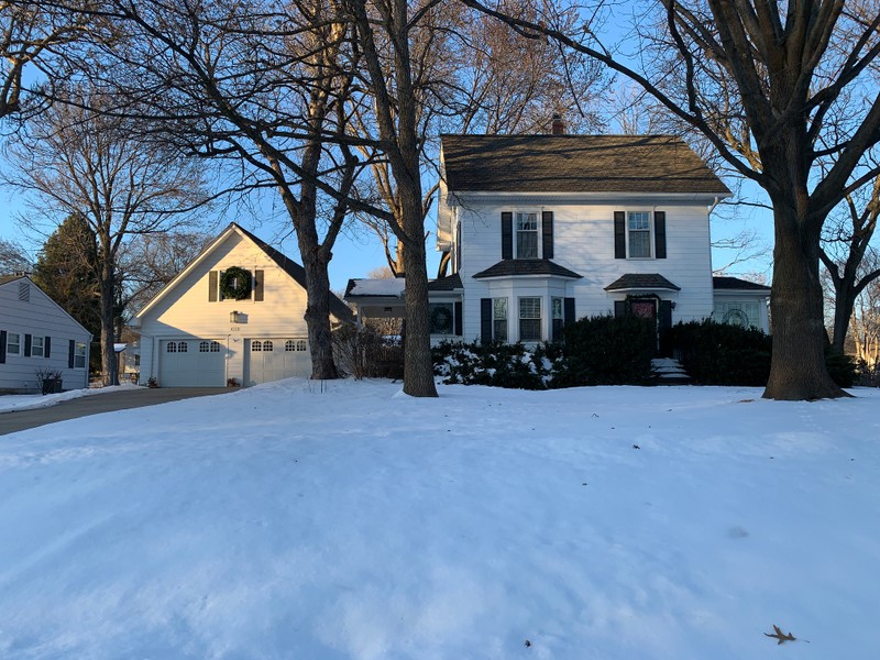
The Tesar Home Today, Roeland Park's oldest surviving structure.
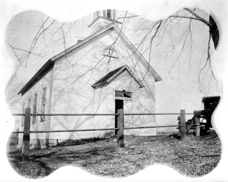
The Shawnee Mission School, where Ana May Tesar attended school. Located where St. Agnes Church sits today.
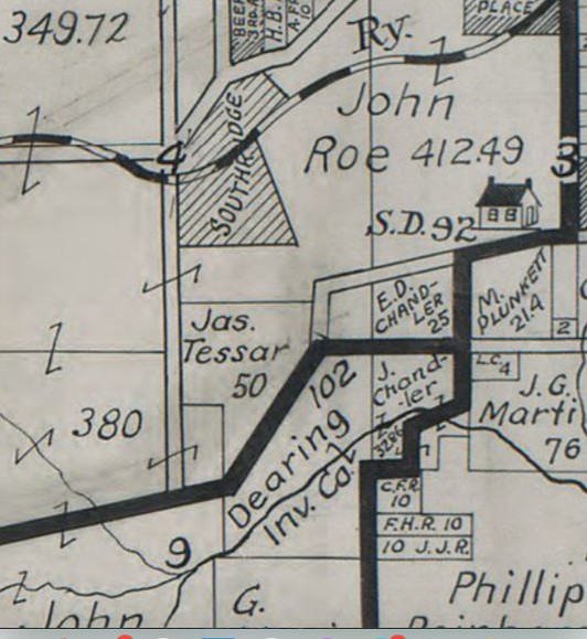
The Tesar farm just south of Southridge and the Strang Line
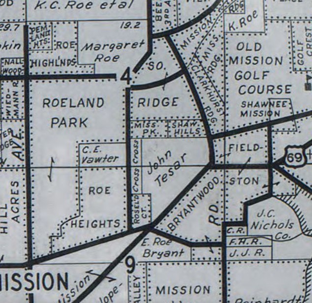
The Tesar Farm surrounded by suburbia in 1930
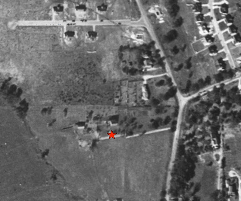
Suburbia surrounds the Tesar Farm in this 1941 aerial photo
Backstory and Context
Text-to-speech Audio
In 1892, Bohemian immigrant John Tesar purchased 50-acres from the descendants of Thomas Johnson, who owned most of the land of what is today Roeland Park, Ks. Here he and his wife Magdelina, started a dairy farm and had their daughter Anna May in 1893. They built this home, completed in 1896, on the crest of a hill overlooking their farm. Ana May would have attended the original Shawnee Mission School (today Roesland Elementary), then located in the small hamlet of Red Clover on the grounds of the former Shawnee Methodist Indian Mission a quarter mile to the east.
At the time, this area of Johnson County was very rural and isolated, despite its close proximity to Kansas City, Mo. However, this was about to change. Entrepreneur William B. Strang built the Kansas Missouri interurban railroad (the Strang Line) in 1906, a quarter mile north of the Tesar Farm. In 1909, Strang purchased land from the heirs of Thomas Johnson and John Wornalll and platted out the Southridge subdivision immediately north of the farm. Strang began promoting his real estate venture by using the Strang Line to bring in prospective buyers from Kansas City. Tesar joined Strang and other large land owners in the area such as John Roe in petitioning the county government to improve area roads and bring public utilities to the area. The Tesars became prominent in the new community of Southridge. They were founding members of the Southridge Presbyterian Church and John was a founding member of the Roesland School board and was frequently elected to county offices such as Mission Township Constable. Anna May married and her husband moved into the home. They started their family here and helped manage the family dairy business.
As the area began to develop in the first half of the 20th century, little by little housing developments began to surround the Tesar farm. By the time of John's death in 1948, it was an island in a sea of suburbia. Today Roeland Park's Shawnee Hills, Mission Park and Buena Vista Heights neighborhoods occupy the northern half of the Tesar Farm. The Fairway Office Park occupies the southern portion.
The Tesar Home, which has been remodeled and expanded several times over the years, is the only reminder of these prominent early residents. It is the oldest home in Roeland Park, Ks.
Cite This Entry
Wolff, Chris. "The Tesar Home." Clio: Your Guide to History. January 16, 2025. Accessed March 25, 2025. https://theclio.com/tour/2742/9
Sources
1900 United State Federal Census for John Tesar, accessed online 1/11/2025, Ancestry.com, https://www.ancestry.com/imageviewer/collections/7602/images/4120149_00643?pId=16854354
1940 United States Federal Census for John Tesar, accessed online 1/11/2025, Ancestry.com, https://www.ancestry.com/imageviewer/collections/2442/images/m-t0627-01237-00232?pId=60529460
"John Tesar." Olathe News (Olathe) January 19th, 1922. .3.
"Citizen's Ticket." Olathe News (Olathe) October 24th, 1902. .1.
"Tesar Obituary." Kansas City Times (Kansas City, Mo.) January 19th, 1948. .11.
Photo courtesy of the Johnson County Historical Society, photo JCM1984-21-46
Photo Courtesy of Chris Wolff
Photo courtesy of the Johnson County Historical Society, Photo JCM1984-21-12
Map of Johnson County, KS. 1912, Gallup Map Company, accessed online 1/11/2025 Kansas City Public Library, Missouri Valley Collection, https://kchistory.org/image/map-johnson-county-kansas?solr_nav%5Bid%5D=b8f040d7d0f4aaedd73c&solr_nav%5Bpage%5D=0&solr_nav%5Boffset%5D=5
Map of Johnson County, Ks. 1930, Gallup Map Company, accessed online on 1/11/2025, Kansas City Public Library, Missouri Valley Collection, https://kchistory.org/image/johnson-county-kansas?solr_nav%5Bid%5D=b8f040d7d0f4aaedd73c&solr_nav%5Bpage%5D=0&solr_nav%5Boffset%5D=3
Johnson County, Ks. government website, AIMS online mapping tool, accessed online 1/11/2025, https://maps.jocogov.org/ims/