Santa Fe Trail Marker #9; Brooklyn, Ks.
Introduction
Text-to-speech Audio
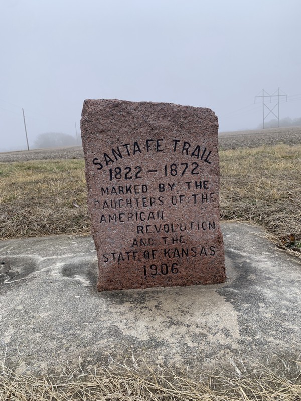
On Oct. 26, 1906, residents of Willow Springs Township and the students of the local High Prairie School helped dedicate the ninth of 96 markers placed by the Kansas Chapters of the Daughters of the American Revolution to mark the route of the Santa Fe Trail through the State of Kansas. This spot commemorates the town of Brooklyn, about a mile northwest of Baldwin City, Ks., founded in 1855 as a rest and supply stop on the Santa Fe Trail. The town is most famous for its destruction at the hands of William Quantrill’s Bushwackers, who pillaged and burned the town as they fled Lawrence on Aug 21, 1863. The town never recovered and faded away.

Images
Santa Fe Trail Marker #9, Brooklyn, Ks.
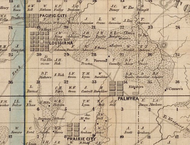
1857 Map of Douglas County showing the location of Louisiana later named Brooklyn
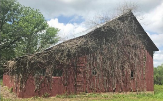
This barn was built by Jacob Ulrich to replace the one burned by William Quantrill and his Bushwackers in 1863.
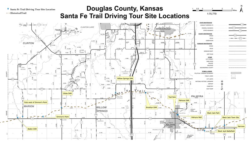
Map of southern Douglas County showing the route of the Santa Fe Trail and the location of the DAR Markers
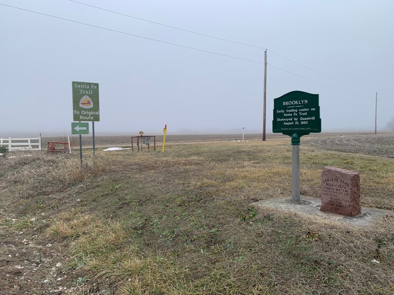
Santa Fe Marker #9, the modern metal interpretive sign, and the NPS sign pointing out the drivable section of the Santa Fe Trail on N. 550 Rd.
Backstory and Context
Text-to-speech Audio
On Oct. 26, 1906, residents from Willow Springs Township and the children of the local High Prairie School gathered to dedicate this stone to mark the Santa Fe Trail and the lost town of Brooklyn. The Douglas County government financed the stone and its installation. In 1983, because of the efforts of local Baker University alumni and trail enthusiasts Amelia Betts and Katharine Kelley, in 1983, the county installed the metal interpretive sign highlighting the site’s connection to the town of Brooklyn.
The town of Louisiana, founded in 1855, was reorganized as Brooklyn in 1857. It served as a supply station for traffic on the Santa Fe, Oregon and California Trails. There were such amenities for travelers as an inn, stable, saloon and general store. This community helped support the growing town of Lawernce, 14 miles to the north and sold their produce to the earliest settlers. Prominent early residents included members of the local German Brethren Church, the Rev. Abraham Rothrock and Jacob Ulrich. Rothrock and Ulrich were abolitionists and had ties to the Underground Railroad.
On Aug. 21, 1863, as William Quantrill and his Bushwackers fled the destruction they had caused in Lawrence, they crossed the Wakarusa River at Blanton’s Bridge and headed south. They paused in the small town of Brooklyn, where Quantrill knew a southern sympathizer and supporter. This man told Quantrill about his abolitionist neighbors Jacob Ulrich and the Rev. Abraham Rothrock, who had sons in the Union Army and who were suspected of helping the Underground Railroad. Quantrill’s men attacked the Ulrich and Rothrock farms setting fire to the houses and outbuildings. The two families hid in the cornfields. However, Mrs. Rothrock ran into her burning home to retrieve some possessions, and on the way out she was met by a man, who raised his gun to shoot her. Seeing this, Abraham rushed from the cornfield to defend his wife and was shot three times. He fell into the open cellar door of the burning house. The family succeeded in pulling Abraham out and he went on to live 7 more years, until finally succumbing to his wounds in 1870. He was the last man shot by Quantrill’s men that day.
The raiders then descended on the town, pillaged its buildings and burned every structure except the saloon. When word came that cavalry from Lawrence was approaching, they fled south leaving Brooklyn burning behind them. The town would never recover and within a couple of years had faded away.
On Oct. 26, 1906, residents from Willow Springs Township and the children of the local High Prairie School gathered to dedicate this stone to mark the Santa Fe Trail and the lost town of Brooklyn. The Douglas County government financed the stone and its installation. In 1983, through the efforts of local Baker University alumni and trail enthusiasts Amelia Betts and Katharine Kelley, in 1983, the county installed the metal interpretive sign highlighting the site’s connection to the town of Brooklyn. A National Parks Service sign indicates a drivable section of the Santa Fe Trail on N. 550 Road.
Cite This Entry
Wolff, Chris. "Santa Fe Trail Marker #9; Brooklyn, Ks. ." Clio: Your Guide to History. February 3, 2025. Accessed March 23, 2025. https://theclio.com/tour/2796/11
Sources
Hill, Barbara J.. Abraham Rothrock, kancoll.org. Accessed February 3rd, 2025. https://www.kancoll.org/articles/rothrock.html.
Jacob H. Ulrich, Findagrave.com. Accessed February 3rd, 2025. https://www.findagrave.com/memorial/86291296/jacob-h-ulrich?_gl=1*q972na*_gcl_au*NDI5Mjg2NjU4LjE3MzcyMjIxNjE.*_ga*MTcyMjAwMzI0My4xNzM3MjIyMTY2*_ga_4QT8FMEX30*ZDhmYWU0MmQtZTM1Mi00MzQ1LWJjMmUtMDJlMDY3NDUwODNlLjEzLjEuMTczODU5NzQ4OC40OC4wLjA.*_ga_LMK6K2LSJH*ZDhmYWU0MmQtZTM1Mi00MzQ1LWJjMmUtMDJlMDY3NDUwODNlLjEzLjEuMTczODU5NzQ4OC4wLjAuMA...
Rev Abraham Rothrock Sr., Findagrave.com. Accessed February 3rd, 2025. https://www.findagrave.com/memorial/16711598/abraham-rothrock?_gl=1*fkq929*_gcl_au*NDI5Mjg2NjU4LjE3MzcyMjIxNjE.*_ga*MTcyMjAwMzI0My4xNzM3MjIyMTY2*_ga_LMK6K2LSJH*ZDhmYWU0MmQtZTM1Mi00MzQ1LWJjMmUtMDJlMDY3NDUwODNlLjE1LjAuMTczODYwNzg2OS4wLjAuMA..*_ga_4QT8FMEX30*ZDhmYWU0MmQtZTM1Mi00MzQ1LWJjMmUtMDJlMDY3NDUwODNlLjE1LjAuMTczODYwNzg2OS42MC4wLjA..
Simmons, Mark. Following the Santa Fe Trail, A Guide For Modern Travelers. Santa Fe, New Mexico. Ancient City Press, 1984.
Kansas Society Daughters of the American Revolution. The Century Survey of the Kansas Santa Fe Trail DAR Markers Placed by the Kansas Society Daughters of the American Revolution in 1906. Topeka, Ks. Kansas Society Daughters of the American Revolution, 2010.
Kelley, Katherine B.. Along the Santa Fe Trail in Douglas County, Kansas: A Brief History of the Seven D.A.R. Marker Sites and Town Sites Along the Route of the Trail in Douglas County, Kansas. Self Published, 1987.
Kansas Chapters Daughters of the American Revolution. Ninetieth Anniversary Survey of the Santa Fe Trail DAR Markers in Kansas. Topeka, Ks. Kansas Society Daughters of the American Revolution, 1997.
Historic Trails of Douglas County, explorelawrence.com. June 29th, 2017. Accessed February 3rd, 2025. https://www.explorelawrence.com/blog/post/historic-trail/.
Willow Springs Township Intensive Survey Report, dgcooks.gov. Accessed February 3rd, 2025. https://www.dgcoks.gov/sites/default/files/2023-07/Intensive%20Survey_Willow%20Springs_2017.pdf.
"Santa Fe Trail." Jeffersonian Gazette (Lawrence) November 28th, 1906. .1.
Santa Fe Trail Landmark Tour, Freedomsfrontier.org. Accessed February 3rd, 2025. https://freedomsfrontier.org/tours/santa-fe-trail-landmark-tour/.
Photo Courtesy of Chris Wolff
Map of Douglas County, Kansas Territory, Stuck, J. Cooper, Surveyor-General's Office, Lecompton, KS. Accessed online 2/3/2025, Kansasmemory.gov, https://www.kansasmemory.gov/item/217187/page/1
Willow Springs Township Intensive Survey Report, dgcooks.gov. Accessed February 3rd, 2025. https://www.dgcoks.gov/sites/default/files/2023-07/Intensive%20Survey_Willow%20Springs_2017.pdf.
Santa Fe Trail Landmark Tour, Freedomsfrontier.org. Accessed February 3rd, 2025. https://freedomsfrontier.org/tours/santa-fe-trail-landmark-tour/.
Photo Courtesy of Chris Wolff