Santa Fe Trail Marker #10; Willow Springs, Ks.
Introduction
Text-to-speech Audio
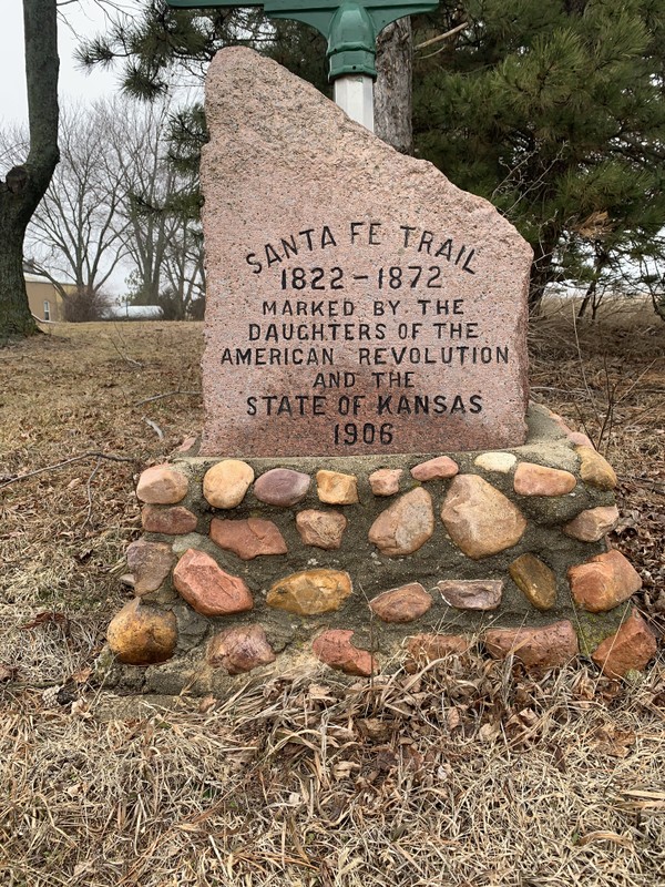
During the Fall of 1906, Edwin Van Hoesen, a long-time resident of Douglas County, personally placed this marker at the townsite of Willow Springs, Ks. It is the tenth of 96 markers commissioned by the Kansas Chapters of the Daughters of the American Revolution that trace the Route of the Santa Fe Trail through the State of Kansas. Willow Springs had been an important watering and camping spot on the trail and the town, originally called Davis, sprang up to service the trade. When traffic on the trail died out with the coming of the railroads, Willow Springs began to fade away. It was nearly a ghost town by 1906.

Images
Santa Fe Trail Marker #10 at the Willow Springs Townsite
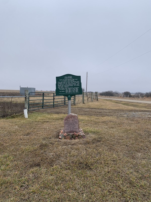
Santa Fe Trail Marker #10 with metal historical sign
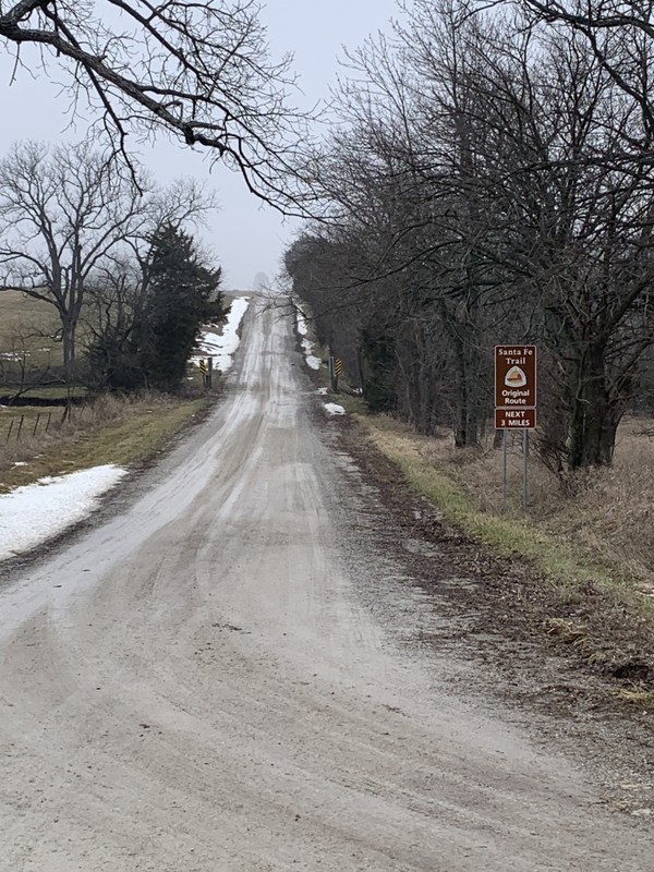
A National Parks Sign denotes a drivable section of the Santa Fe Trail on N 550 rd.
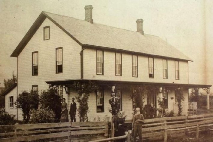
The Willow Springs Hotel and Van Hoesen residence. The building burned down in 1908.
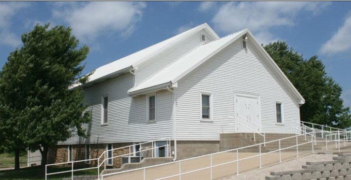
The German Baptist Brethren Church, built in the 1880s, is the only surviving structure from Willow Springs
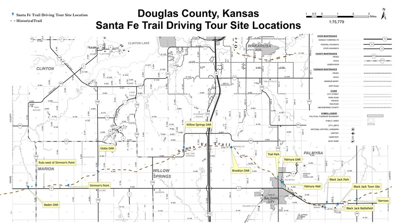
Map of Santa Fe Trail locations including the DAR stones in Douglas County
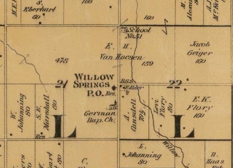
1887 Douglas County Plat Map showing Willow Springs. The hotel/residence, church and school locations are all shown. The DAR marker sits in front of the hotel location.
Backstory and Context
Text-to-speech Audio
One of the tenets of the Daughters of the American Revolution is “To perpetuate the memory of the spirit of men and women who achieved American Independence, by the acquisition and protection of historical spots, and the erection of monuments.” However, there being no sites even remotely associated with the American Revolution in the State of Kansas, the four Kansas chapters of the D.A.R. had long pondered how they would follow this mission. They had made some modest contributions to some local projects such as the Zebulon Pike monument in Republic County, Ks. but hadn’t spearheaded a project of their own. At the state conference in 1902, it was proposed that they mark the route of the Santa Fe Trail through Kansas, a project made official in 1903. Since its abandonment in 1872, much of the route had been forgotten or covered up by modern roads, farms, and towns. With much of the former trail lost, the Daughters of the American Revolution worked to rediscover its route, a task made even more difficult by the fact that travelers along the trail often took slightly different paths.
Over the next few years, a committee of D.A.R. volunteers consulted old maps and interviewed original settlers to ascertain the original route of the trail. As soon as people heard of the project, they received many letters from locals offering to help. Their assistance was invaluable, especially in the western sections, where the trail split into northern and southern branches. From their research, they commissioned their own map detailing the route through each county. By 1904, the D.A.R. was ready to petition the state legislature for funding. They consulted the “women clubs” in all the communities through which the trail passed to determine the best locations for markers. They determined the size and format for the markers, a bronze plaque on a red granite boulder sourced from Oklahoma. Their inspiration was the Santa Fe Trail marker in Kansas City, Missouri’s Penn Valley Park. In the end, due to cost constraints, they opted to chisel the same inscription on the face of each monument.
In the end, the state appropriation of $1000 would prove to be far too little for the 96 markers they planned. They budgeted $20 per marker for construction, freight charges, concrete foundations and installment costs. So the D.A.R. appealed to Kansas school children and asked that they each donate a penny to the cause. This raised another $700. A few private individuals also sponsored the stones in their communities and Douglas County paid for its five stones. The markers were constructed and delivered throughout 1907 and early 1908. A team of workers was arranged ahead of time in each community to receive and install the stone at the prescribed location. Each dedication was a cause for celebration for the various communities. In all, the D.A.R. had successfully delivered and had installed 96 stone trail markers across the entire length of the Santa Fe Trail in Kansas.
This marker sits on the site of the former town of Willow Springs. Originally founded as the town of Davis in 1855 to service Santa Fe Trail traffic, the town had a few shops and one of Kansas Territory’s earliest post offices. Border Ruffians under Colonel Henry K. Pate, attacked the town in 1858, robbing the inhabitants of their money, guns and horses and then setting fire to all the buildings. Three townsmen were shot trying to defend the town.
In 1860, Edwin H. Hoesen purchased the former townsite of Davis and eventually renamed it Willow Springs in 1881, after the nearby spring that had once attracted the Santa Fe Trail traffic. Van Hoesen was born in New York and as a young man made his fortune in the soap and hair products business. In 1856, he moved his family to the area where he purchased a farm and began raising livestock. He eventually acquired 400 acres.
He built a hotel in 1868 that also served as the town store, post office and his home. Other town buildings included a German Brethren Church and the Willow Springs School. However, as the traffic on the Santa Fe Trail began to dwindle with the building of the railroads, Willow Springs struggled to survive as a rural farm town. The post office closed in 1900 and by the time the site was chosen by the Kansas DAR as a location for a Santa Fe Trail Marker in 1906, it was nearly a ghost town. Van Hoesen, one of the last remaining residents, personally placed the marker without ceremony. His hotel and residence burned down in 1908.
Today the only surviving original structure is the Willow Springs Baptist Brethren Church, built in the 1880s, located just south on E. 1100 Rd.
The marker itself was moved back from its original location when the road was widened. Road crews built the stone base at that time. The Metal Interpretive sign was placed by Douglas County in 1983. A National Parks Service sign points out a drivable section of the Santa Fe Trial on N. 550 rd.
Cite This Entry
Wolff, Chris. "Santa Fe Trail Marker #10; Willow Springs, Ks.." Clio: Your Guide to History. February 5, 2025. Accessed March 23, 2025. https://theclio.com/tour/2796/12
Sources
Cordry, Mrs. T.A.. The Story of the Marking of the Santa Fe Trail. Topeka, KS. Crane & Company, 1915.
Kelley, Katherine B.. Along the Santa Fe Trail in Douglas County, Kansas: A Brief History of the Seven D.A.R. Marker Sites and Town Sites Along the Route of the Trail in Douglas County, Kansas. Self Published, 1987.
Kansas Society Daughters of the American Revolution. Ninetieth Anniversary Survey of the Santa Fe Trail DAR Markers in Kansas. Topeka, Ks. Kansas Society Daughters of the American Revolution, 1997.
Kansas Society Daughters of the American Revolution. The Century Survey of the Kansas Santa Fe Trail DAR Markers Placed by the Kansas Society Daughters of the American Revolution in 1906. Topeka, Ks. Kansas Society Daughters of the American Revolution, 2010.
Willow Springs Township Intensive Survey Report, dgcoks.gov. Accessed February 4th, 2025. https://www.dgcoks.gov/sites/default/files/2023-07/Intensive%20Survey_Willow%20Springs_2017.pdf.
Alexander, Kathy. Willow Springs, Kansas-Extinct in Douglas County, Legends of Kansas. June 1st, 2022. Accessed February 4th, 2025. https://legendsofkansas.com/willow-springs-kansas/.
Santa Fe Landmark Tour, Freedom's Frontier. Accessed February 4th, 2025. https://freedomsfrontier.org/tours/santa-fe-trail-landmark-tour/.
Photo Courtesy of Chris Wolff
Willow Springs Township Intensive Survey Report, dgcoks.gov. Accessed February 4th, 2025. https://www.dgcoks.gov/sites/default/files/2023-07/Intensive%20Survey_Willow%20Springs_2017.pdf.
Willow Springs Township Intensive Survey Report, dgcoks.gov. Accessed February 4th, 2025. https://www.dgcoks.gov/sites/default/files/2023-07/Intensive%20Survey_Willow%20Springs_2017.pdf.
Santa Fe Landmark Tour, Freedom's Frontier. Accessed February 4th, 2025. https://freedomsfrontier.org/tours/santa-fe-trail-landmark-tour/.
Edwards Map of Douglas County, Edwards, John P., 1887, Quincy, Ill. Accessed online 2/5/2025, Library of Congress Website, https://www.loc.gov/resource/g4203d.la000213/?r=0.571,0.074,0.44,0.22,0