Santa Fe Trail Marker #11; Globe, Ks.
Introduction
Text-to-speech Audio
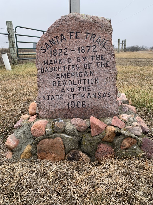
This marker was originally installed a little to the south of this location, in front of the home and store of William Featherston, longtime postmaster of the town of Globe. The Santa Fe Trail crossed at this point just to the north. Featherston and his neighbor August Koch placed the stone in the fall of 1906 without ceremony. It was moved to this spot at the junction of E. 550 Rd and N. 400 Rd. in modern times when the road was paved. Today nothing remains of Globe except for the pump from the town school and the 1938 Globe store, located 1 mile south on Highway 56.

Images
Santa Fe Trail Marker #11 in Globe, Ks.
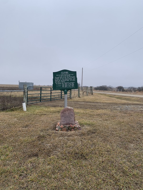
Santa Fe Trail Marker and Douglas County Historical Sign for Globe
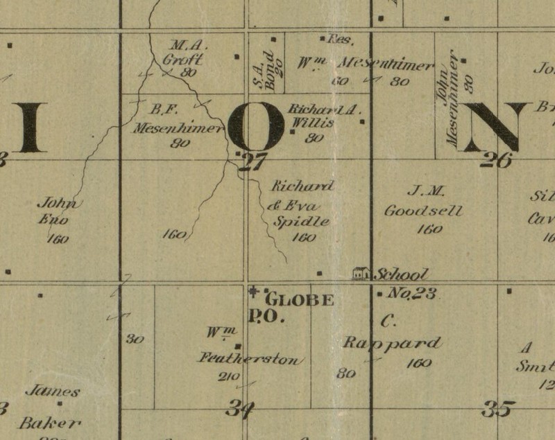
The Town of Globe, Ks. on the 1887 Plat Map of Douglas County. The location of the store/post office, the Featherston home and Globe School are all marked.
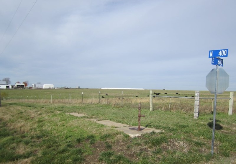
The last remnant of Globe is the pump from the town school
Backstory and Context
Text-to-speech Audio
One of the tenets of the Daughters of the American Revolution is “To perpetuate the memory of the spirit of men and women who achieved American Independence, by the acquisition and protection of historical spots, and the erection of monuments.” However, there being no sites even remotely associated with the American Revolution in the State of Kansas, the four Kansas chapters of the D.A.R. had long pondered how they would follow this mission. They had made some modest contributions to some local projects such as the Zebulon Pike monument in Republic County, Ks. but hadn’t spearheaded a project of their own. At the state conference in 1902, it was proposed that they mark the route of the Santa Fe Trail through Kansas, a project made official in 1903. Since its abandonment in 1872, much of the route had been forgotten or covered up by modern roads, farms, and towns. With much of the former trail lost, the Daughters of the American Revolution worked to rediscover its route, a task made even more difficult by the fact that travelers along the trail often took slightly different paths.
Over the next few years, a committee of D.A.R. volunteers consulted old maps and interviewed original settlers to ascertain the original route of the trail. As soon as people heard of the project, they received many letters from locals offering to help. Their assistance was invaluable, especially in the western sections, where the trail split into northern and southern branches. From their research, they commissioned their own map detailing the route through each county. By 1904, the D.A.R. was ready to petition the state legislature for funding. They consulted the “women clubs” in all the communities through which the trail passed to determine the best locations for markers. They determined the size and format for the markers, a bronze plaque on a red granite boulder sourced from Oklahoma. Their inspiration was the Santa Fe Trail marker in Kansas City, Missouri’s Penn Valley Park. In the end, due to cost constraints, they opted to chisel the same inscription on the face of each monument.
In the end, the state appropriation of $1000 would prove to be far too little for the 96 markers they planned. They budgeted $20 per marker for construction, freight charges, concrete foundations and installment costs. So the D.A.R. appealed to Kansas school children and asked that they each donate a penny to the cause. This raised another $700. A few private individuals also sponsored the stones in their communities and Douglas County paid for its five stones. The markers were constructed and delivered throughout 1907 and early 1908. A team of workers was arranged ahead of time in each community to receive and install the stone at the prescribed location. Each dedication was a cause for celebration for the various communities. In all, the D.A.R. had successfully delivered and had installed 96 stone trail markers across the entire length of the Santa Fe Trail in Kansas.
This marker sits on the site of the town of Globe, Ks., originally founded in 1857 as Marion, two miles south of this location. It was named in honor of General Francis Marion from the Revolutionary War. A post office was founded in 1858, and quickly the town boasted a blacksmith, shops, church and a few houses. Entrepreneur David Hubbard soon built a store one mile north of town, at what is today the southwest corner of Highway 56 and N. 500 Rd. The store became a stagecoach stop known as Hubbard’s Stage Stand.
In May of 1863, a band of Bushwackers led by Dick Yeager stopped at Hubbard’s home after having pillaged the town of Diamond Springs about 90 miles west on the Santa Fe Trail. They called him out and shot him. After robbing his house, they stole a horse from the stage stop and continued east towards Missouri. Yeager would participate in the raid on Lawrence later that year. Hubbard survived, but soon abandoned his business and joined the Union Army. After the war, he settled in Johnson County.
Like most towns near the Santa Fe Trail, Marion declined as traffic dwindled because of the railroads and the post office closed. However, in 1886, an English immigrant and Civil War veteran William Featherston, moved his family to the area and purchased land near Marion. He reopened a town store and post office for Marion at this location, 2 miles north of the original town. The new site sat on the Santa Fe Trail, which crossed through the town. In 1881, in order to avoid confusion at the post office with the town of Marion Center, Ks., Featherston changed the name of the town to Globe. A local joke was that the name of the town came from the fact that “there was nothing to see ‘round’ there.”
In 1900, the post office closed for good, and the town was well on its way to abandonment. The Bethel Methodist Church, located at the original townsite of Marion 2 miles south was moved to Globe in 1902. Douglas County also had located a rural school just east of town some time before 1887. However, by the time the DAR stone was placed in 1906, there were only 47 residents in the area. Today all that remains of the town is the pump from the school, visible from the road ½ mile to the east and the Globe Store, built in 1938, 1 mile south on Highway 56, long after the actual town of Globe had become a memory. The site of this store on Highway 56 is listed as Globe on modern maps.
When E. 550 Rd was widened and paved by the county, this marker was moved north to this location and set back. A new base was constructed by the road crew using glacial rock from the Clinton Lake area. The metal interpretive sign outlining Globe’s history was added by the county in 1983.
Cite This Entry
Wolff, Chris. "Santa Fe Trail Marker #11; Globe, Ks. ." Clio: Your Guide to History. February 5, 2025. Accessed March 23, 2025. https://theclio.com/tour/2796/13
Sources
Alexander, Kim. Globe Community, Douglas County, Legends of America. February 1st, 2024. Accessed February 5th, 2025. https://www.legendsofamerica.com/ks-santafetraildgco/.
"Globe." Jeffersonian Gazette (Lawrence) October 31st, 1906. .3.
"Whoa! Here we are at Globe." Kansas Daily Tribune (Lawrence) February 7th, 1882. .3.
Cordry, Mrs. T.A.. The Story of the Marking of the Santa Fe Trail. Topeka, KS. Crane & Company, 1915.
Kelley, Katherine B.. Along the Santa Fe Trail in Douglas County, Kansas: A Brief History of the Seven D.A.R. Marker Sites and Town Sites Along the Route of the Trail in Douglas County, Kansas. Self Published, 1987.
Kansas Society Daughters of the American Revolution. Ninetieth Anniversary Survey of the Santa Fe Trail DAR Markers in Kansas. Topeka, Ks. Kansas Society Daughters of the American Revolution, 1997.
Kansas Society Daughters of the American Revolution. The Century Survey of the Kansas Santa Fe Trail DAR Markers Placed by the Kansas Society Daughters of the American Revolution in 1906. Topeka, Ks. Kansas Society Daughters of the American Revolution, 2010.
"Public Member Trees," database, Ancestry.com (http://www.ancestry.com: accessed 2/5/2025) Heather Bailey Family Tree by Heather Bailey, profile for William Featherston, https://www.ancestry.com/family-tree/person/tree/162172324/person/182327665641/facts
Cutler, William G.. History of the State of Kansas. Chicago, Ill. A.T. Andreas, 1883.
Stone, Raymond L, "Globe School District No. 23," Douglas County, Kansas Rural and One Room Schools (prior to 1966) and more, accessed 2/5/2025, https://www.facebook.com/groups/2018946758373384/search/?q=featherston
Photo Courtesy of Chris Wolff
Photo Courtesy of Chris Wolff
Edwards, John P. Map of Douglas County, 1887, Quincy, Ill. Accessed online 2/5/2025, Library of Congress Website, https://www.loc.gov/resource/g4203d.la000213/?r=0.662,0.123,0.358,0.179,0
"Public Member Trees," database, Ancestry.com (http://www.ancestry.com: accessed 2/5/2025) Heather Bailey Family Tree by Heather Bailey, profile for William Featherston, https://www.ancestry.com/family-tree/person/tree/162172324/person/182327665641/facts