Santa Fe Trail Marker #12; Baden, Ks. and the Simmons Point Stage Station
Introduction
Text-to-speech Audio
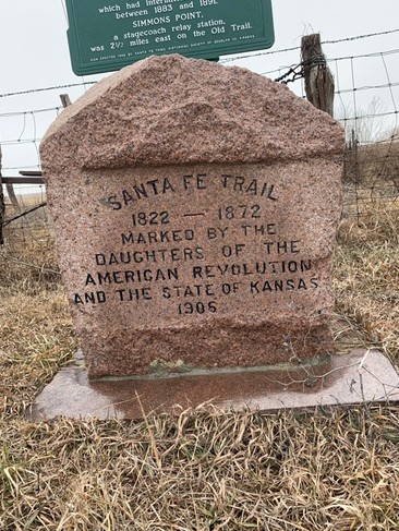
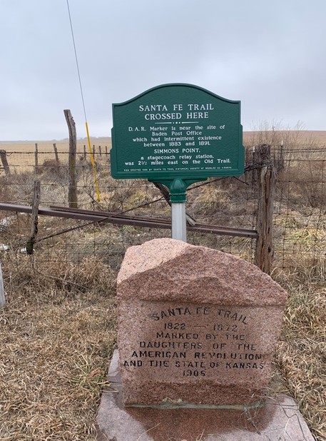
This marker was set without ceremony sometime during 1906 or 1907. However, no records or contemporary newspaper articles reference its placement. In fact, in the official history of the markers, The Story of The Marking of the Santa Fe Trail, states that this particular stone was placed at the “famous” Flag Springs, which has not been located. The marker sits at the location of the post office of the small Santa Fe Trail settlement of Baden, Ks., and near the historic Simmons Point Stagecoach Station. A metal interpretive sign provides context on these locations.

Images
Santa Fe Trail Marker #12 at the Baden townsite
Metal Historical Marker provides context for Baden and nearby Simmons Point
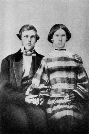
Phillip and Elmira Simmons wedding photo 1859
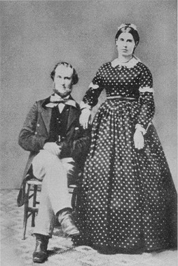
Phillip and Elmira Simmons in 1870
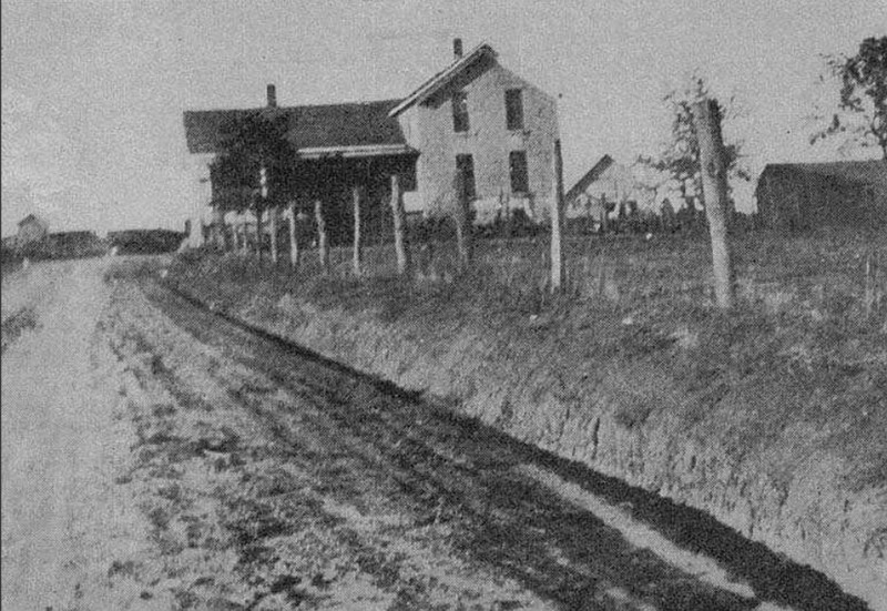
The 1870 Simmons home circa 1957
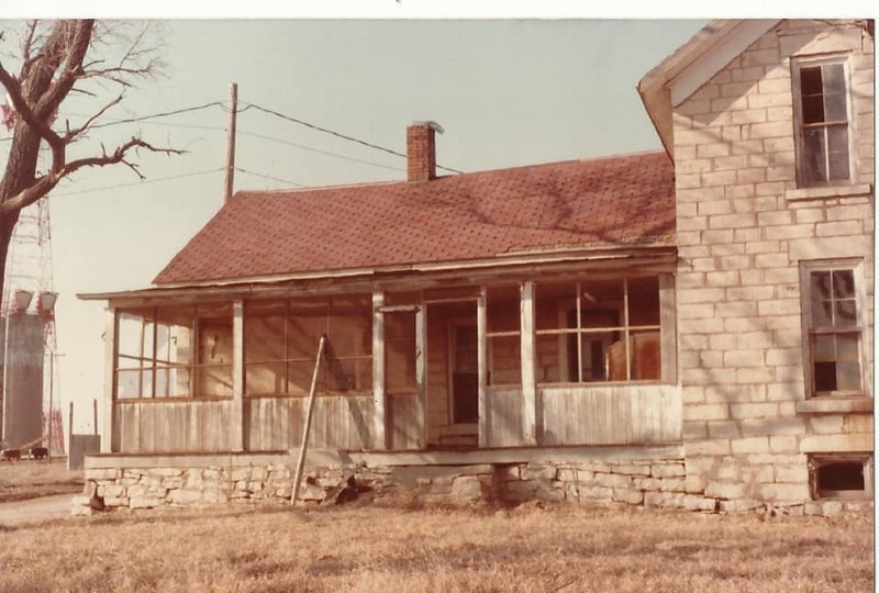
The 1870 Simmons home at Simmons Point before it fell into ruin
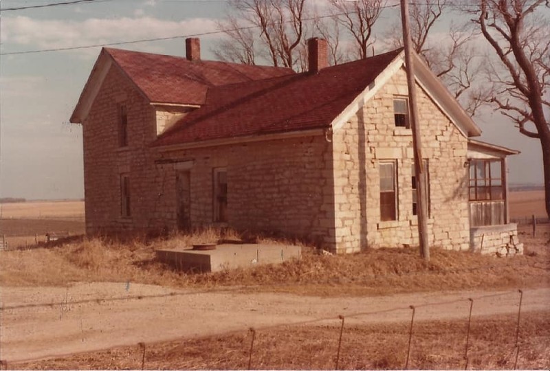
The 1870 Simmons home at Simmons Point before it fell into ruin
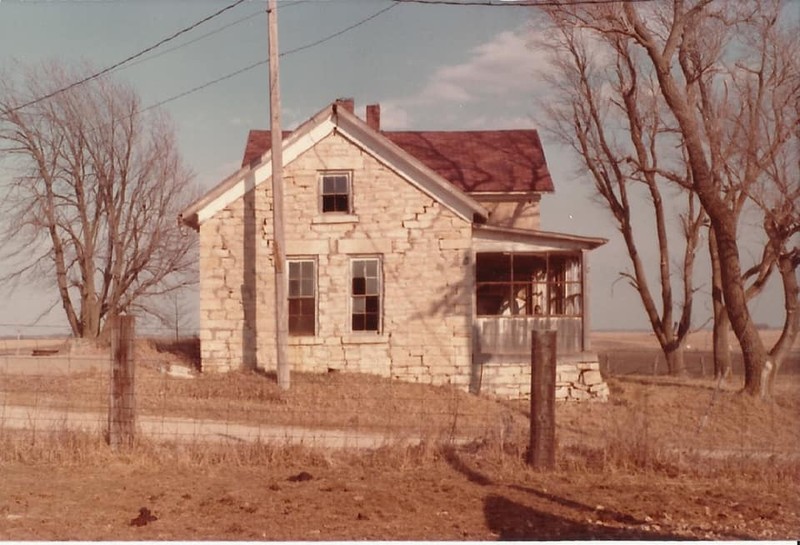
The 1870 Simmons home at Simmons Point before it fell into ruin
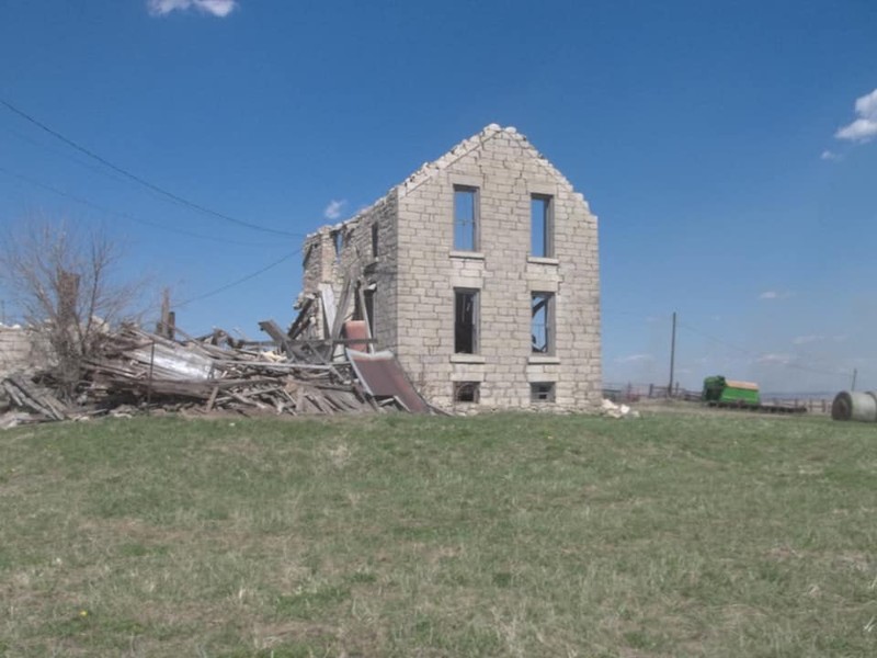
The 1870 Simmons Home today
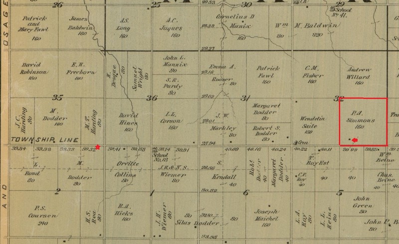
1887 Map of Douglas County. The location of this marker and the Simmons farm and home are marked.
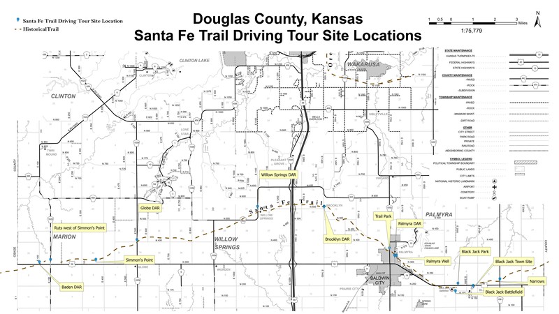
Map of Santa Fe Trail sites in Douglas County, Ks.
Backstory and Context
Text-to-speech Audio
One of the tenets of the Daughters of the American Revolution is “To perpetuate the memory of the spirit of men and women who achieved American Independence, by the acquisition and protection of historical spots, and the erection of monuments.” However, there being no sites even remotely associated with the American Revolution in the State of Kansas, the four Kansas chapters of the D.A.R. had long pondered how they would follow this mission. They had made some modest contributions to some local projects such as the Zebulon Pike monument in Republic County, Ks. but hadn’t spearheaded a project of their own. At the state conference in 1902, it was proposed that they mark the route of the Santa Fe Trail through Kansas, a project made official in 1903. Since its abandonment in 1872, much of the route had been forgotten or covered up by modern roads, farms, and towns. With much of the former trail lost, the Daughters of the American Revolution worked to rediscover its route, a task made even more difficult by the fact that travelers along the trail often took slightly different paths.
Over the next few years, a committee of D.A.R. volunteers consulted old maps and interviewed original settlers to ascertain the original route of the trail. As soon as people heard of the project, they received many letters from locals offering to help. Their assistance was invaluable, especially in the western sections, where the trail split into northern and southern branches. From their research, they commissioned their own map detailing the route through each county. By 1904, the D.A.R. was ready to petition the state legislature for funding. They consulted the “women clubs” in all the communities through which the trail passed to determine the best locations for markers. They determined the size and format for the markers, a bronze plaque on a red granite boulder sourced from Oklahoma. Their inspiration was the Santa Fe Trail marker in Kansas City, Missouri’s Penn Valley Park. In the end, due to cost constraints, they opted to chisel the same inscription on the face of each monument.
In the end, the state appropriation of $1000 would prove to be far too little for the 96 markers they planned. They budgeted $20 per marker for construction, freight charges, concrete foundations and installment costs. So the D.A.R. appealed to Kansas school children and asked that they each donate a penny to the cause. This raised another $700. A few private individuals also sponsored the stones in their communities and Douglas County paid for its five stones. The markers were constructed and delivered throughout 1907 and early 1908. A team of workers was arranged ahead of time in each community to receive and install the stone at the prescribed location. Each dedication was a cause for celebration for the various communities. In all, the D.A.R. had successfully delivered and had installed 96 stone trail markers across the entire length of the Santa Fe Trail in Kansas.
This stone was set without ceremony sometime in 1906 or 1907 one mile east of the Douglas/Osage County line. The official DAR history, The Story of The Marking of the Santa Fe Trail, simply states that a stone was placed at this location to mark the famous Flag Springs. However, no such exists today at the location or on historical maps. When the DAR researched sites to place the markers, they consulted “old settlers” and men who had once worked on the trail. Perhaps this was their source of information about Flag Springs. It is more likely that the marker was placed at this location because it is adjacent to the extinct town of Baden and close to the better-known Simmons Point Stagecoach Station. The metal historic sign was added by Douglas County in 1983. This stone was refurbished and a new base added by the DAR in 2007.
Very little is known about the town of Baden other than that it had a post office from 1883 to 1886 and from 1888-1891. It is even possible that the post office was operated out of the post masters’ houses and there never was an independent post office buildings. Baden sat on the Santa Fe Trail, which heads southwest into Osage County at this location, but its existence was long after the trail had faded in importance and the town likely had nothing to do with trade. Perhaps Baden was built on the site of an unknown settlement or even the forgotten Flag Springs. Baden does not appear on the 1873, 1887 or 1902 plat maps of Douglass County.
The Simmons Point Stagecoach Station sat on a highpoint on the Santa Fe Trail about 2 ½ miles east of this location on the north side of what is today 56 Highway. This was the location of the farm of Phillip and Elmira Simmons. Elmira’s father, Peter Dodder, one of the original pioneers of Douglas County, purchased the farm for the couple in 1859 as a wedding present.
There are conflicting historical traditions about the Simmons family. One tradition is that the couple ran an independent stagecoach station for Santa Fe Trail traffic at this location. It was a place where stages would exchange horses or mules for the next leg of the journey to Burlingame, Ks. Passengers would be able to rest and eat. However, according to the memoirs of Zoe Dentler, Phillip and Elmira’s granddaughter, who grew up in the area, the stagecoach station, predated the farm and was owned by the David A. Butterfield Stage Coach Company. The Simmons family sold meals to stage passengers and Santa Fe Trail travelers out of the small home they built on the farm but did not manage the station. Whatever the case, it is unknown what years the station operated. However, it likely was discontinued during or after the Civil War, when trade traffic on the Santa Fe Trail dwindled and eventually stopped altogether.
In 1870, Phillip and Elmira, built the large stone house, whose ruins stand on the site today. Here they raised their three children and managed their farm and livestock operations. Phillip would purchase cattle in Texas and drive them up to Dodge City, Ks. and then back home on the Santa Fe Trail. The farm grew corn, vegetables and fruit for market. In 1886, A government survey team, which was planning the route of what is today 56 Highway, camped on the Simmons farm, since it was the high point in the area. They named the hill “Simmons Point,” a name that has remained attached to the site.
In 1892, Phillip’s cart overturned in an accident and he was injured, suffering intermittent paralysis the rest of his life. His general health began a slow decline and he passed away in 1901. Elmira passed away 3 years later. The family home was eventually abandoned and has been falling into ruin ever since. Apparently there are no aboveground traces of the stage station.
Today the site of Simmons Point is on private property on the north side of 56 Highway, about 2 ½ miles east of this location. The house is visible from the highway. It was certified as an historic site by the National Park Service in 1995. However, no action has been taken by any agency to preserve the site or the structure.
Cite This Entry
Wolff, Chris. "Santa Fe Trail Marker #12; Baden, Ks. and the Simmons Point Stage Station." Clio: Your Guide to History. February 6, 2025. Accessed March 23, 2025. https://theclio.com/tour/2796/14
Sources
Kansas Society Daughters of the American Revolution. The Century Survey of the Kansas Santa Fe Trail DAR Markers Placed by the Kansas Society Daughters of the American Revolution in 1906. Topeka, Ks. Kansas Society Daughters of the American Revolution, 2010.
Cordry, Mrs. T.A.. The Story of the Marking of the Santa Fe Trail. Topeka, KS. Crane & Company, 1915.
Kelley, Katherine B.. Along the Santa Fe Trail in Douglas County, Kansas: A Brief History of the Seven D.A.R. Marker Sites and Town Sites Along the Route of the Trail in Douglas County, Kansas. Self Published, 1987.
Time Running Out for Historic Structure, Lawrence Journal World. May 14th, 2006. Accessed February 6th, 2025. https://www2.ljworld.com/news/2006/may/14/time_running_out/.
"Phillip A. Simmons Obituary." Overbrook Citizen (Overbrook, Ks.) May 16th, 1901. .1.
Stone, Raymond L, "Piece on Simmons Point," Douglas County, Kansas Rural and One Room Schools (prior to 1966) and more, accessed 2/5/2025, https://www.facebook.com/groups/2018946758373384/search/?q=simmons
Dentler, Zoe. The Hill or Simmons Point. New York, New York. Greenwich Book Publishers, 1957.
Staresinic-Deane, Diana. Exploring the Sante Fe Trail: Douglas County, Kansas, Unearthing Stories on the Prairie. Accessed February 6th, 2025. https://dianastaresinicdeane.wordpress.com/tag/simmons-point-stage-station/.
Alexander, Kathy. Simmons Point Douglas County, Legends of America. Accessed February 6th, 2025. https://www.legendsofamerica.com/ks-santafetraildgco/.
Santa Fe Trail Landmark Tour, Freedom's Frontier. Accessed February 6th, 2025. https://freedomsfrontier.org/tours/santa-fe-trail-landmark-tour/.
Photo Courtesy of Chris Wolff
Photo Courtesy of Chris Wolff
Dentler, Zoe. The Hill or Simmons Point. New York, New York. Greenwich Book Publishers, 1957.
Dentler, Zoe. The Hill or Simmons Point. New York, New York. Greenwich Book Publishers, 1957.
Dentler, Zoe. The Hill or Simmons Point. New York, New York. Greenwich Book Publishers, 1957.
Stone, Raymond L, "Piece on Simmons Point," Douglas County, Kansas Rural and One Room Schools (prior to 1966) and more, accessed 2/5/2025, https://www.facebook.com/groups/2018946758373384/search/?q=simmons
Stone, Raymond L, "Piece on Simmons Point," Douglas County, Kansas Rural and One Room Schools (prior to 1966) and more, accessed 2/5/2025, https://www.facebook.com/groups/2018946758373384/search/?q=simmons
Stone, Raymond L, "Piece on Simmons Point," Douglas County, Kansas Rural and One Room Schools (prior to 1966) and more, accessed 2/5/2025, https://www.facebook.com/groups/2018946758373384/search/?q=simmons
Staresinic-Deane, Diana. Exploring the Sante Fe Trail: Douglas County, Kansas, Unearthing Stories on the Prairie. Accessed February 6th, 2025. https://dianastaresinicdeane.wordpress.com/tag/simmons-point-stage-station/.
Map of Douglas County, Kansas. Edwards, John P. 1887, Quincy, Illinois. Accessed online 2/6/2025, Library of Congress Website, https://www.loc.gov/resource/g4203d.la000213/?r=-0.008,0.748,0.236,0.118,0
Santa Fe Trail Landmark Tour, Freedom's Frontier. Accessed February 6th, 2025. https://freedomsfrontier.org/tours/santa-fe-trail-landmark-tour/.