Santa Fe Trail Marker #19; Elm Creek Crossing
Introduction
Text-to-speech Audio
This was the nineteenth of 96 markers placed by the Kansas Chapters of the Daughters of the American Revolution to trace the route of the Santa Fe Trail through the State of Kansas between 1906 and 1908. Lyon County was given three markers, and a committee of men from Allen, Admire, and Bushong decided the locations for placement. Despite the attempts of the commercial clubs in each town to create a celebration around the installation of the markers, this one was placed without ceremony on May 20, 1907, at the Santa Fe Trail crossing of Elm Creek near the old mail stagecoach station. The marker was later moved to this location for greater visibility and is just north of the 99 Highway bridge over Elm Creek, a bridge that spans the original crossing during the trail era. The marker is down the embankment and can easily be missed, especially if the grass is high.

Images
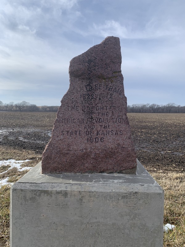
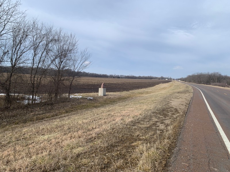
Santa Fe Trail Marker #19. It sits far down the embankment and is easy to miss, just north of the Elm Creek Bridge on 99 Highway.
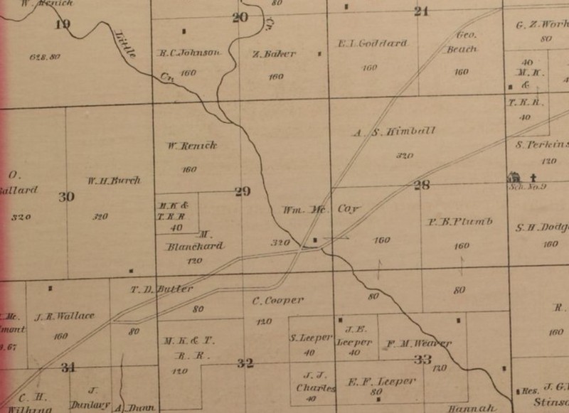
1878 Map of Lyon County showing the location of the Santa Fe Trail Crossing at Elm Creek. The former mail stage station is marked. This is the location of the DAR marker today.
Backstory and Context
Text-to-speech Audio
History of This Marker
In April 1907, the Commercial Club of the Town of Allen, Kansas, received three of the DAR trail markers with instructions to install one at each end of the Santa Fe Trail’s route through Lyon County and one at a significant spot in the middle. A committee of men from the towns of Allen, Admire, and Bushong decided to place the eastern marker for their county at the trail’s crossing of Elm Creek, near the old mail stagecoach station site. Despite the efforts of the three towns’ commercial clubs and the local newspaper to organize a dedication ceremony and celebration similar to those in other communities along the trail, the stone was placed without fanfare on May 20, 1907, at this location near the crossing and the ruins of the old stage station.
At his point, the Santa Fe trail was hard-packed and 100 to 150 feet wide. This width facilitated the trail traffic since wagon trains could easily pass each other. Also, the width of trail provided a fire break for small range fires. The trail crossed Elm Creek about 100 yards east of this location at a spot known locally as “Hard Bottom Ford.” There was a good camping place nearby, which made it a popular stopping point along the trail. Later, a mail stage station was built at this spot. During peak traffic, this location saw as many as 500 wagons cross daily. Locals continued to use the crossing long after the Santa Fe Trail had been abandoned until the county built a bridge at the site of the crossing in 1885.
Today, this marker is the only reminder of the Santa Fe Trail in this area. The ruins of the mail station have long since disappeared. The marker sits on a concrete pedestal well down the embankment on the west side of 99 Highway and is easy to miss. Start looking just north of the Elm Creek bridge. The nearest physical address is a farm about a half mile to the north, 3875 ks-99, Admire, KS.
History of the 96 D.A.R. Markers
One of the tenets of the Daughters of the American Revolution is “To perpetuate the memory of the spirit of men and women who achieved American Independence, by the acquisition and protection of historical spots, and the erection of monuments.” With no sites directly associated with the American Revolution in the State of Kansas, the four Kansas chapters of the D.A.R. explored how they might support this mission while contributing to some local projects, such as the Zebulon Pike monument in Republic County. Prior to their state conference in 1902, the organizations hadn’t spearheaded a project of their own. At that conference, leaders proposed an ambitious project to mark the route of the Santa Fe Trail through Kansas, and they announced their plans the following year. The trail saw a rapid decline in use following the completion of the transcontinental railroad and other rail routes, and had been entirely abandoned by 1872. As a result, most of the trail's route had been lost to time, and many parts were covered by modern roads or home to farms and towns. With much of the former trail lost, the Daughters of the American Revolution worked to rediscover its route, a task made even more difficult by the fact that travelers along the trail often took slightly different paths.
Over the next few years, a committee of D.A.R. volunteers consulted old maps and interviewed original settlers to ascertain the original route of the trail. As word of the project spread, D.A.R. members received many letters from locals offering to help. Their assistance was invaluable, especially in the western sections, where the trail split into northern and southern branches. From their research, they commissioned their own map detailing the route through each county. By 1904, the D.A.R. was ready to petition the state legislature for funding. D.A.R. members worked with various women's clubs in each of the communities through which the trail passed to determine the best locations for markers. They also determined the size and format for the markers, a bronze plaque on a red granite boulder sourced from Oklahoma. Their inspiration for this model marker was the Santa Fe Trail marker in Kansas City, Missouri’s Penn Valley Park. While they initially hoped to craft unique markers that shared the history of each of the 96 sites, cost constraints and the limited space for text led them to chisel the same inscription on the face of each monument.
Even with the economy of scale in producing 96 identical markers, their budget for the project averaged $20 per marker to cover construction and installation. A state appropriation of $1000 would only support half of that amount, so D.A.R. members appealed to Kansas school children, asking that they each donate a penny to the cause. This raised another $700. A few private individuals also sponsored the stones in their communities, and Douglas County paid for its five stones. The markers were constructed and delivered throughout 1906 and early 1907. A team of workers was arranged ahead of time in each community to receive and install the stone at the prescribed location. Each dedication was a cause for celebration for the various communities. In all, the D.A.R. had successfully delivered and installed 96 stone trail markers across the entire length of the Santa Fe Trail in Kansas in just two years.
Cite This Entry
Wolff, Chris and Clio Admin. "Santa Fe Trail Marker #19; Elm Creek Crossing." Clio: Your Guide to History. February 10, 2025. Accessed March 23, 2025. https://theclio.com/tour/2796/21
Sources
Kansas Society Daughters of the American Revolution. The Century Survey of the Kansas Santa Fe Trail DAR Markers Placed by the Kansas Society Daughters of the American Revolution in 1906. Topeka, Ks. Kansas Society Daughters of the American Revolution, 2010.
Cordry, Mrs. T.A.. The Story of the Marking of the Santa Fe Trail. Topeka, KS. Crane & Company, 1915.
"The Gold Rush." Kansas City Journal (Kansas City, Mo.) May 22nd, 1860. .3.
"Santa Fe Trail Memorials." Emporia Weekly Journal (Emporia, Ks.) April 26th, 1907. .1.
"Elm Creek Bridge." Weekly News-Democrat (Emporia, Ks.) January 29th, 1885. .1.
Alexander, Kathy. Lyon County, Kansas on the Santa Fe Trail, Legends of America. May 1st, 2022. Accessed February 10th, 2025. https://www.legendsofamerica.com/ks-santafetraillyco/.
Photo Courtesy of Chris Wolff
Photo Courtesy of Chris Wolff
An Illustrated Historical Atlas of Lyon County, Kansas. 1878, Edwards Brothers Publishing, Philadelphia, Accessed online 2/10/2025, Kansas State Historical Society Website, https://www.kansasmemory.gov/item/223971/page/2