Santa Fe Trail Marker #6, Black Jack Park & Ivan Boyd Prairie Preserve
Introduction
Text-to-speech Audio
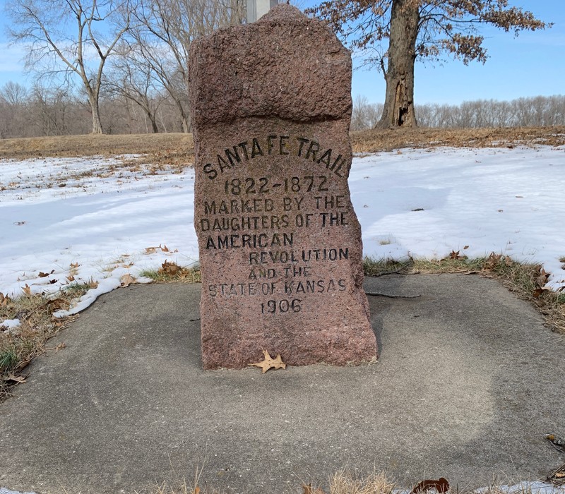
This roadside park 2.5 miles east of Baldwin, Ks. is the location of the sixth of 96 markers placed by the Daughters of the American Revolution from 1906-1908, which denote the route of the Santa Fe Trail through the State of Kansas. The monument was originally placed on July 1, 1908 at the location of the ghost town of Black Jack, 1/2 mile east on Highway 56. It was moved to this spot in 1967, when Douglas County purchased 18 acres of native prairie at this location, which have preserved numerous traces of the Santa Fe Trail. The Ivan Boyd Prairie Preserve is named in honor of Ivan Boyd, a long time faculty member of Baldwin's Baker University, who shared his loved of nature and conservation with generations of students.

Images
Santa Fe Trail Marker #6
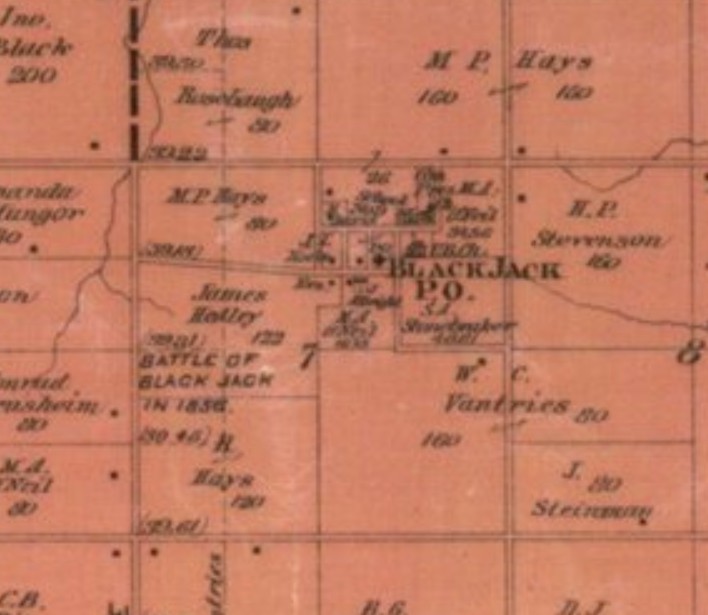
1887 Map of Douglas County Kansas showing the town of Black Jack and the nearby site of the Battle of Black Jack in 1856.
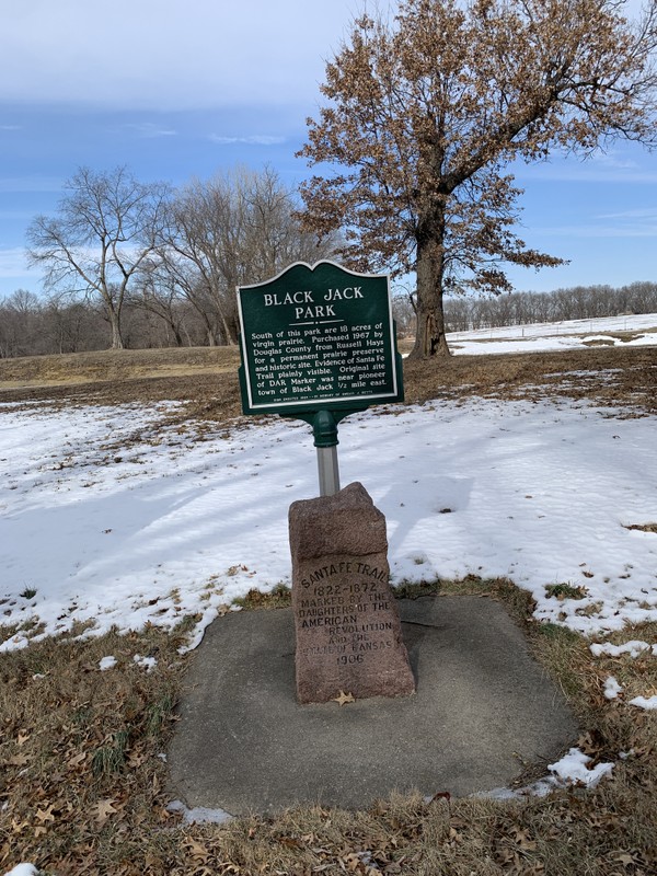
Santa Fe Trail Marker #6 and interpretive sign
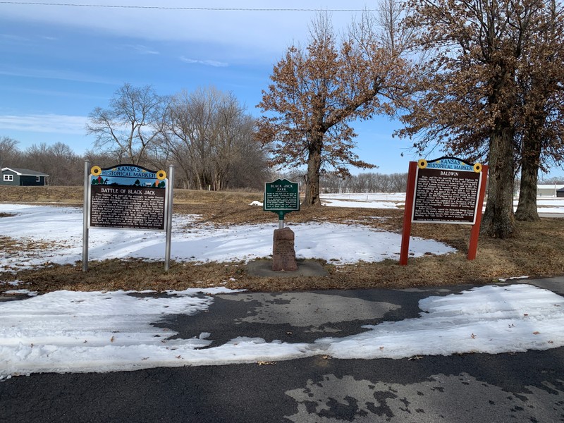
Historical markers in the roadside Black Jack Park just east of Baldwin, Ks.
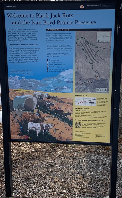
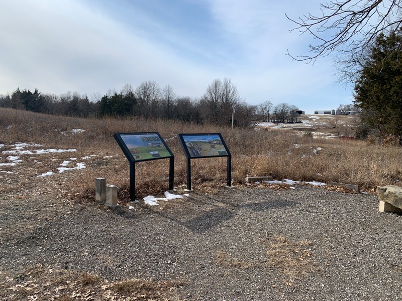
Interpretive Sign at the entrance to the Ivan Boyd Prairie Preserve
Interpretive Signs in the Ivan Boyd Prairie Preserve
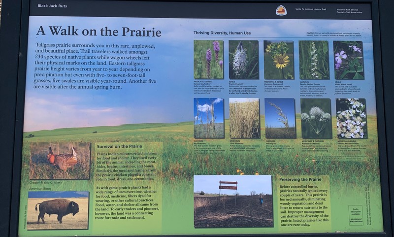
Interpretive Sign in the Ivan Boyd Prairie Preserve
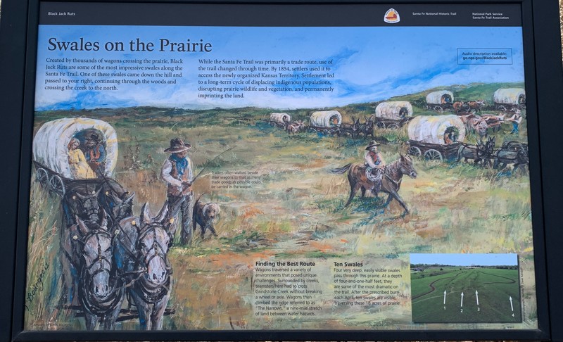
Interpretive Sign in the Ivan Boyd Prairie Preserve
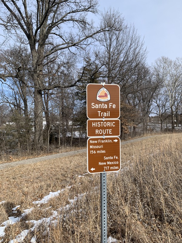
National Park Service Sign pointing out the distances to the Santa Fe Trial's original starting and stopping points. Trail ruts visible, highlighted by snow
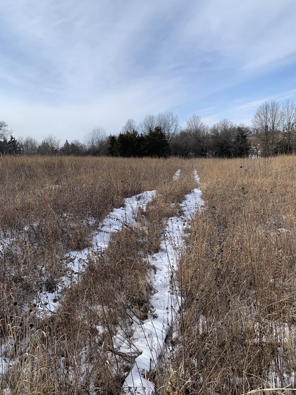
Santa Fe Trail ruts highlighted by snow
Backstory and Context
Text-to-speech Audio
One of the tenets of the Daughters of the American Revolution is “To perpetuate the memory of the spirit of men and women who achieved American Independence, by the acquisition and protection of historical spots, and the erection of monuments.” However, there being no sites even remotely associated with the American Revolution in the State of Kansas, the four Kansas chapters of the D.A.R. had long pondered how they would follow this mission. They had made some modest contributions to some local projects such as the Zebulon Pike monument in Republic County, Ks. but hadn’t spearheaded a project of their own. At the state conference in 1902, it was proposed that they mark the route of the Santa Fe Trail through Kansas, a project made official in 1903. Since its abandonment in 1872, much of the route had been forgotten or covered up by modern roads, farms, and towns. With much of the former trail lost, the Daughters of the American Revolution worked to rediscover its route, a task made even more difficult by the fact that travelers along the trail often took slightly different paths.
Over the next few years, a committee of D.A.R. volunteers consulted old maps and interviewed original settlers to ascertain the original route of the trail. As soon as people heard of the project, they received many letters from locals offering to help. Their assistance was invaluable, especially in the western sections, where the trail split into northern and southern branches. From their research, they commissioned their own map detailing the route through each county. By 1904, the D.A.R. was ready to petition the state legislature for funding. They consulted the “women clubs” in all the communities through which the trail passed to determine the best locations for markers. They determined the size and format for the markers, a bronze plaque on a red granite boulder sourced from Oklahoma. Their inspiration was the Santa Fe Trail marker in Kansas City, Missouri’s Penn Valley Park. In the end, due to cost constraints, they opted to chisel the same inscription on the face of each monument.
In the end, the state appropriation of $1000 would prove to be far too little for the 96 markers they planned. They budgeted $20 per marker for construction, freight charges, concrete foundations and installment costs. So the D.A.R. appealed to Kansas school children and asked that they each donate a penny to the cause. This raised another $700. A few private individuals also sponsored the stones in their communities and Douglas County paid for its five stones. The markers were constructed and delivered throughout 1907 and early 1908. A team of workers was arranged ahead of time in each community to receive and install the stone at the prescribed location. Each dedication was a cause for celebration for the various communities. In all, the D.A.R. had successfully delivered and had installed 96 stone trail markers across the entire length of the Santa Fe Trail in Kansas. From 2006-2010, the D.A.R. resurveyed all 96 markers and made repairs to the stones and bases as necessary.
The sixth stone in the series was placed on July 1, 1908 1/2 mile east of this location at the site of Black Jack, a former town on the Santa Fe Trail. Judge J.Q.A. Norton of Lawrence placed the stone without ceremony at the former site of Sam Stonebraker's store, which once sat on the trail in Black Jack. Black Jack was founded in 1854 as a repair and supply station for the trail. It was the location for much violence during the "Bleeding Kansas" period, notably the Battle of Black Jack 1/2 mile west in 1856. During the Civil War, it was famously raided by Bushwackers led by "Bloody Bill" Anderson, who intercepted a stage coach in the town and stole 14 horses and $2000 from the passengers.
After the Santa Fe Trail was replaced by the railroad, the population of the town began to dwindle. The post office closed in 1894 and the town was soon abandoned and most traces vanished. When the Daughters of the American Revolution decided to locate a trail marker in Black Jack, Judge J. Q. A. Norton of Lawrence was enlisted to place the marker because he had known Sam Stonebraker, an original town founder and he knew the exact location of Stonebraker's store and the route of the trail in the area.
In 1967, Douglas County purchased 18 acres of native prairie land at a site outside of Baldwin, near the location of the Battle of Black Jack. They created the Ivan Boyd Prairie Reserve, as a nature reserve, named in honor of Baker University faculty member and conservationist Ivan Boyd. This park preserves some of the best traces of wagon ruts on the Santa Fe Trail. Adjacent to the reserve, the county also created the small Black Jack Park to showcase this D.A.R. marker and and small interpretive sign.
Cite This Entry
Wolff, Chris. "Santa Fe Trail Marker #6, Black Jack Park & Ivan Boyd Prairie Preserve." Clio: Your Guide to History. February 13, 2025. Accessed March 23, 2025. https://theclio.com/tour/2796/8
Sources
"Santa Fe Trail Marker." Jeffersonian Gazette (Lawrence) July 1st, 1908. .7.
Black Jack Kansas, legendsofkansas.com. Accessed February 2nd, 2025. https://legendsofkansas.com/black-jack-kansas/.
Cordry, Mrs. T.A.. The Story of the Marking of the Santa Fe Trail. Topeka, KS. Crane & Company, 1915.
Kelley, Katherine B.. Along the Santa Fe Trail in Douglas County, Kansas: A Brief History of the Seven D.A.R. Marker Sites and Town Sites Along the Route of the Trail in Douglas County, Kansas. Self Published, 1987.
Kansas Society Daughters of the American Revolution. The Century Survey of the Kansas Santa Fe Trail DAR Markers Placed by the Kansas Society Daughters of the American Revolution in 1906. Topeka, Ks. Kansas Society Daughters of the American Revolution, 2010.
Kansas Society Daughters of the American Revolution. Ninetieth Anniversary Survey of the Santa Fe Trail DAR Markers in Kansas. Topeka, Ks. Kansas Society Daughters of the American Revolution, 1997.
Photo Courtesy of Chris Wolff
Map of Douglas County, Kansas. Edward, John P., Quincy, Ill. 1887. Accessed online 2/2/2025, Kansas State Historical Society Website, https://www.kansasmemory.gov/item/217197/page/1
Photo Courtesy of Chris Wolff
Photo Courtesy of Chris Wolff
Photo Courtesy of Chris Wolff
Photo Courtesy of Chris Wolff
Photo Courtesy of Chris Wolff
Photo Courtesy of Chris Wolff
Photo Courtesy of Chris Wolff
Photo Courtesy of Chris Wolff