Highway Overlook - Lost Foggy Bottom
Introduction
Text-to-speech Audio
The corner of 26th and I Streets offers a view of the Foggy Bottom area that was destroyed when the Potomac Freeway - an extension of I-66 from Roosevelt Bridge - was built in the mid 1960s. The highway construction wiped out several blocks of historic Foggy Bottom, including renovated row houses, alleys, and an elementary school. Three remaining historic row houses are visible on I & 27th Streets, across the Freeway. The area also included an ancient Native American burial site, a reminder of the area's first residents.

Images
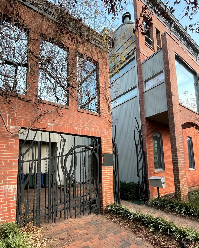
Paley's sculptural gates at 901 26th St. corner house
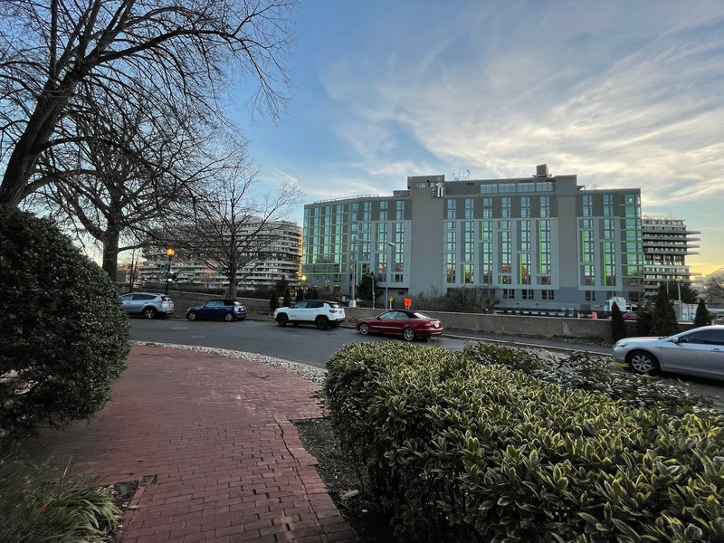
The Watergate complex and the Boathouse condominium
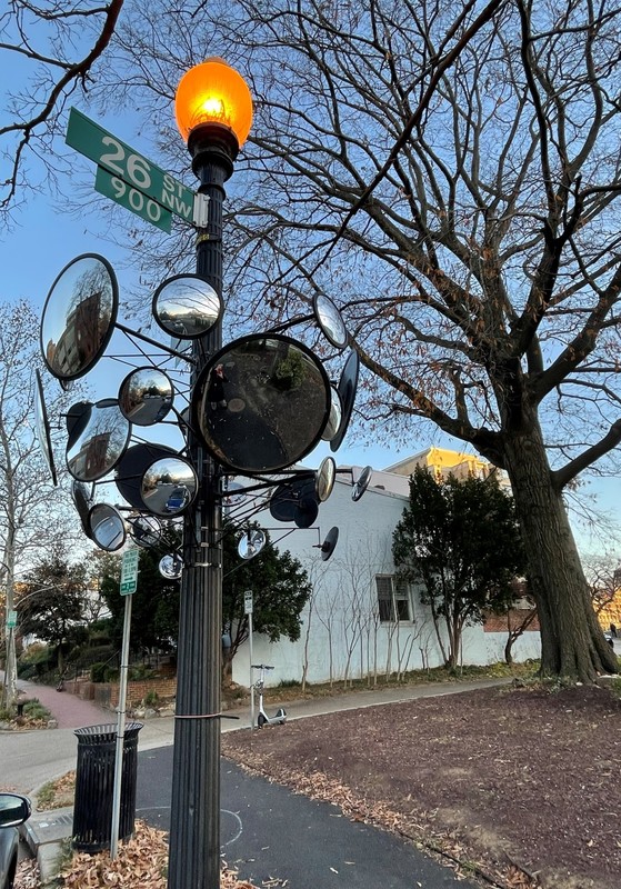
Graham Caldwell's "Watching Post" sculpture - note the reflections in the mirrors
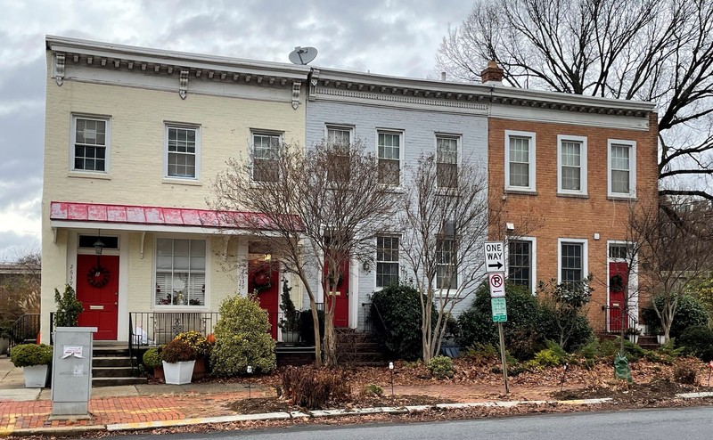
Remaining I St. row houses with 26th St. (across the freeway) in the background
.jpg)
Remaining I St. houses - note that 2639 has two front doors
1909 Baist Map showing lost square 1 and 5, replaced by the Potomac Freeway
.jpg)
26th Street in the 1960s
Potomac River Freeway nearing completion
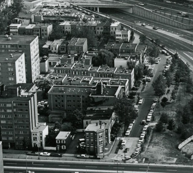
Aerial view of Foggy Bottom with the Potomac Freeway to the right
Potomac Freeway- Inner Loop construction eliminates three residential blocks, 240+ homes
.jpg)
Backstory and Context
Text-to-speech Audio
The three-story red brick corner house at 26th and I Streets (901 26th St.) was built in 1878 as a house and store. In 1914, it was a saloon operated by Robert Stauber. But by 1923 - after Prohibition took effect - the building housed the Universal Holiness Church. The house has been renovated and the elaborate painted ironwork gates were installed in 1981. The gates were created by sculptor Albert Paley, who also created the "Portal Gates" in 1974 for the Smithsonian's Renwick Gallery near the White House.
26th Street overlooks the Potomac Freeway (I-66). In the 1960s, planners intended to connect this highway with additional roads to form an "Inner Loop Beltway" within Washington D.C. Fortunately, the effort was blocked and funding went to the Metro subway system instead. But this section of highway was built before the plan was abandoned and the highway wiped out about one-third of the neighborhood and displaced over 270 families. Demolished buildings included: The Briggs-Montgomery Elementary School, originally an African American School built in 1903 (named for Margaret Briggs, an African American educator and contemporary of Frederick Douglas, and H.P. Montgomery, an African American school administrator from the late 1800s), the Sharon Baptist Church (900 27th St.); Green’s Court (Square 5, between 26th and 27th, I and K Sts.), which had houses that had been recently renovated; and the Robert Peter House at 27th and K Streets, owned by the Mayor of Georgetown, where George Washington actually slept on his visits to D.C. in the 1790s (including on his last night in Washington, August 5, 1799).
It could have been worse – the original plan was to route a six-lane highway down 25th Street, displacing even more people and wiping out more historic homes. After protests from the community and developers, the highway was relocated to the west.
The three isolated row houses (2635, 2637, 2639 I St.) in the distance are all that remains of the neighborhood west of 26th Street. Nos. 2635 and 2637 were constructed in 1879 by Peter McCartney for owner Gilbert Cannon. The houses are relatively simple and are two stories and three bays wide. The façade of No. 2635 has been replaced. No. 2639 is a single dwelling that appears to have been designed as a double residence, and has a side entrance as well as two front doors. It was built by W.H. Serrin and owned by Edward Welsh in 1877. The houses were included in the original proposal for the Foggy Bottom Historic District, but omitted from the final designation, so they lack historic protection. The highway construction has left the houses difficult to access.
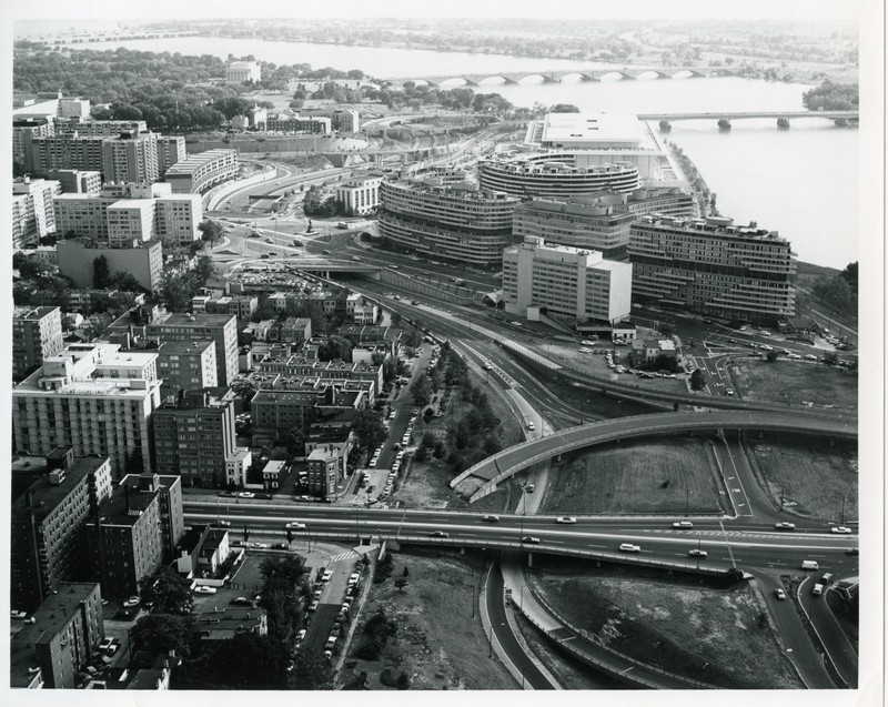
Looking toward Georgetown is the Whitehurst Freeway (b.1949). Excavation for Whitehurst renovations in 1996 unearthed a Native American burial site that contained the cremated remains and grave goods of a high status 30 to 40 year old woman. Artifacts included a comb carved from antler, fossil shark teeth, beads, and cloth. The site dated from between AD 640 and 790, towards the end of the Middle Woodland period. The Site was located beneath the historical remains of what was Reed Alley, about 15 feet below ground surface. Other artifacts, including potsherds and stone tools found throughout the area show native people camped here as long as 5,000 years ago.
Across the highway to the South is the Boathouse condominium and the Watergate office-apartment-hotel complex. The Boathouse (b. 2019) replaces a Howard Johnson’s hotel (b. 1960). The Watergate break-in team monitored the June 1972 bungled DNC burglary and wire-tapping from room 723 of that hotel. From 1999 to 2016, The George Washington University owned the building and used it as a dormitory, The Hall on Virginia Avenue.
The corner park area includes a stately heritage tree that survived all the transitions in the neighborhood. This corner also hosts an elevated multi-mirrored sculpture. Entitled “Watching Post,” it was created by artist Graham Caldwell and installed in 2014 as one of the exhibition sculptures in the Arts in Foggy Bottom Biannual event. It was purchased with funds from the FBA and some residents. With all its mirrors, it's also highly functional.
Cite This Entry
FBA History Project, . "Highway Overlook - Lost Foggy Bottom." Clio: Your Guide to History. February 21, 2023. Accessed April 22, 2025. https://theclio.com/entry/142862
Sources
Jackson, Luther P, "Highway Projects Doom Homes in Foggy Bottom," Washington Post, Jan. 1, 1962
"Inner Loop Held School Threat; Hearing Sought," The Evening Star, June 14, 1957, at p. 27
"The West End of Washington," Evening Star, Mar. 17, 1964
National Park Service, “The Whitehurst Freeway Sites, Rock Creek Park” (see link below)
National Park Service, "Prehistoric Burial Sites of the Nation's Capitol" (see link below)
Boyd's City Directory for the District of Columbia, 1914, 1923
Vogt/Leone, 2021
Vogt/Leone, 2021
Vogt/Leone, 2021
Leone/Vogt, 2021
Vogt/Leone, 2021
Library of Congress, 1909 Baist Map, Vol. 1, Plate 2
Washington DC Department of Transportation Historic Collections
Google Maps, 2021
Washington Star, Mar. 1964